Address
304 North Cardinal St.
Dorchester Center, MA 02124
Work Hours
Monday to Friday: 7AM - 7PM
Weekend: 10AM - 5PM

Address
304 North Cardinal St.
Dorchester Center, MA 02124
Work Hours
Monday to Friday: 7AM - 7PM
Weekend: 10AM - 5PM
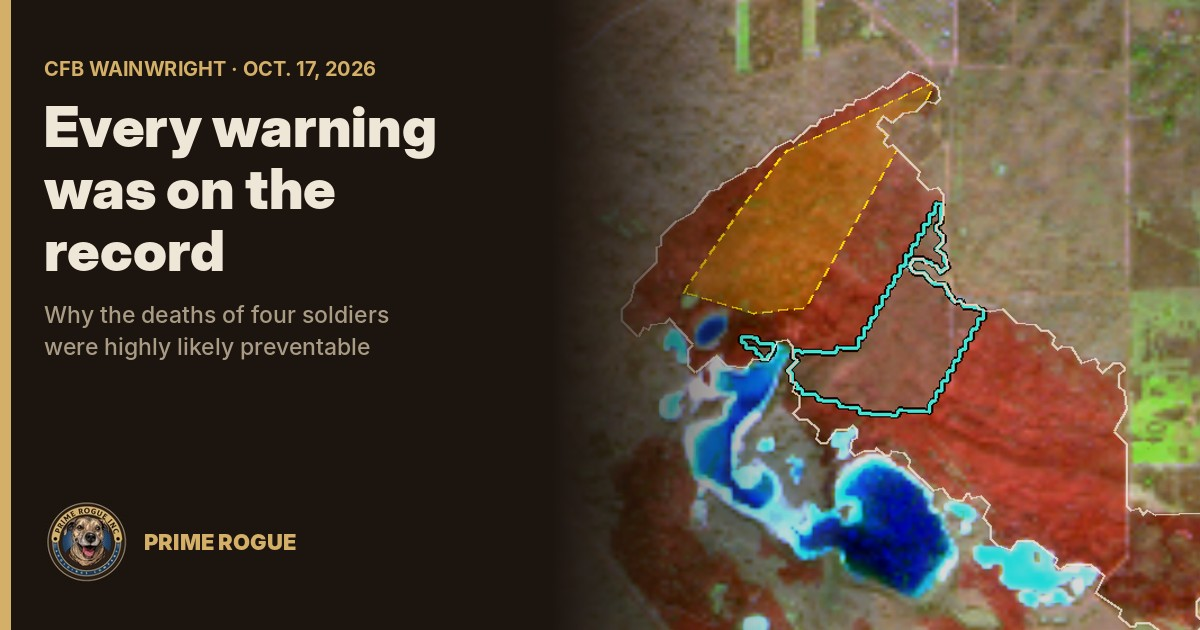
In Prime Rogue’s assessment, the deaths of four soldiers at CFB Wainwright on Oct. 17 were highly likely preventable. Every warning sign that mattered was on the public record before the wind turned: a fire burning for hours about a kilometre away, an “Extreme” fire-danger rating, and a forecast, then a warning, of the wind that drove it onto C Company. Whether the failure lay with the chain of command that kept training going, or with those responsible for giving it that information, the outcome was the same. A catastrophic error of judgment led to the deaths of four of Canadian’s finest.
The grass fire that killed four soldiers at CFB Wainwright on Oct. 17 was burning on the range by 12:17 p.m., almost four hours before the time National Defence gave. The wind that drove it onto C Company of the 3rd Battalion, Princess Patricia’s Canadian Light Infantry, was forecast twice that morning and named in a warning about an hour before it arrived.
A Prime Rogue analysis of public satellite imagery, weather records, fire-behaviour models and flight-tracking data finds that if the fire was about a kilometre away when the wind shifted, as Maj.-Gen. Wade Rutland said, C Company was likely in the area around the base’s grenade range and a north–south range road. The fire most likely reached them between about 3:25 and 3:45 p.m. Standard fire models put its speed at 4.4 to 12 km/h, five to 14 minutes to cover that kilometre. The military has said it covered it in 30 to 60 seconds.
The training was routine: grenade throwing and a section attack, for a deployment to Latvia about six months away. In Prime Rogue’s assessment, the decision to continue it about a kilometre from an active fire, under “Extreme” fire danger and a forecast wind shift toward the troops, likely exposed them to a risk out of proportion to its purpose.
National Defence has not explained why training continued. Asked 10 specific questions before publication, it declined to answer them, saying the investigation remains active, at 05:15 AM MSt on October 21, 2026.
This is an analysis of public data, written in calibrated probabilities. It is not a finding of cause or fault; three investigations are under way. Every data file is in Prime Rogue’s public archive.
Prime Rogue uses the probability language of intelligence analysis. Almost certainly means 95% or more; highly likely, 80–95%; likely, 55–80%; roughly even, 45–55%; unlikely, 20–45%; very unlikely, 5–20%; remote, under 5%. Confidence describes the quality of the evidence behind each judgment, not the probability.
Four soldiers died and 39 people were taken to hospital after a grass fire swept over a training range at CFB Wainwright, Alberta, on Saturday, Oct. 17.
The dead are Sgt. Morgan Wong of Edmonton, of the Loyal Edmonton Regiment, serving with the 3rd Battalion, Princess Patricia’s Canadian Light Infantry; Pte. Shaun Farrell of Prince Albert, Sask.; Pte. Aidan Goulding of North Vancouver, B.C.; and Pte. Hayden Lykkemark of Langley, B.C. Premier Danielle Smith said 19 of those taken to hospital were in critical condition. Acute Care Alberta put the split at 19 critical, eight stable and 12 ambulatory.
At an Oct. 18 briefing, Maj.-Gen. Wade Rutland, commander of 1st Canadian Division, said about 84 soldiers of C Company, 3 PPCLI, were training with live munitions as part of high-intensity training ahead of a deployment to Latvia, reported for April and May. According to reports of the briefing:
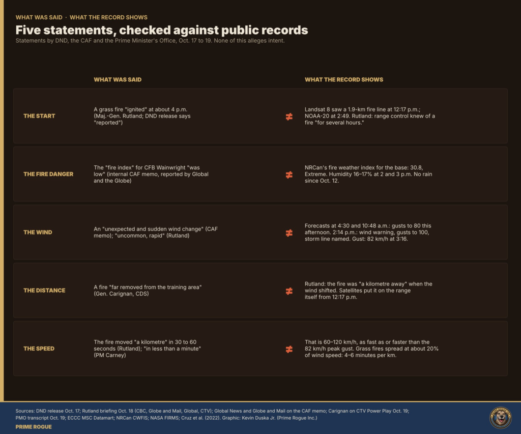
National Defence and Rutland put the fire at about 4 p.m. Chief of the Defence Staff Gen. Jennie Carignan described a fire “far removed from the training area.” A Canadian Armed Forces memo reported by Global News and The Globe and Mail described the wind change as unexpected and, as the outlets paraphrased it, a fire index that was low. Prime Minister Mark Carney called it a “violent, fast-moving fire.
Officials say the cause is unknown. Rutland said a “multitude of ordnance” was in use that day, and that the cause “could have been any of that, or none of it.” The RCMP and military police, the fire marshal and a board of inquiry are investigating. Defence Minister David McGuinty said Oct. 20 that training procedures had not changed “as of now.”
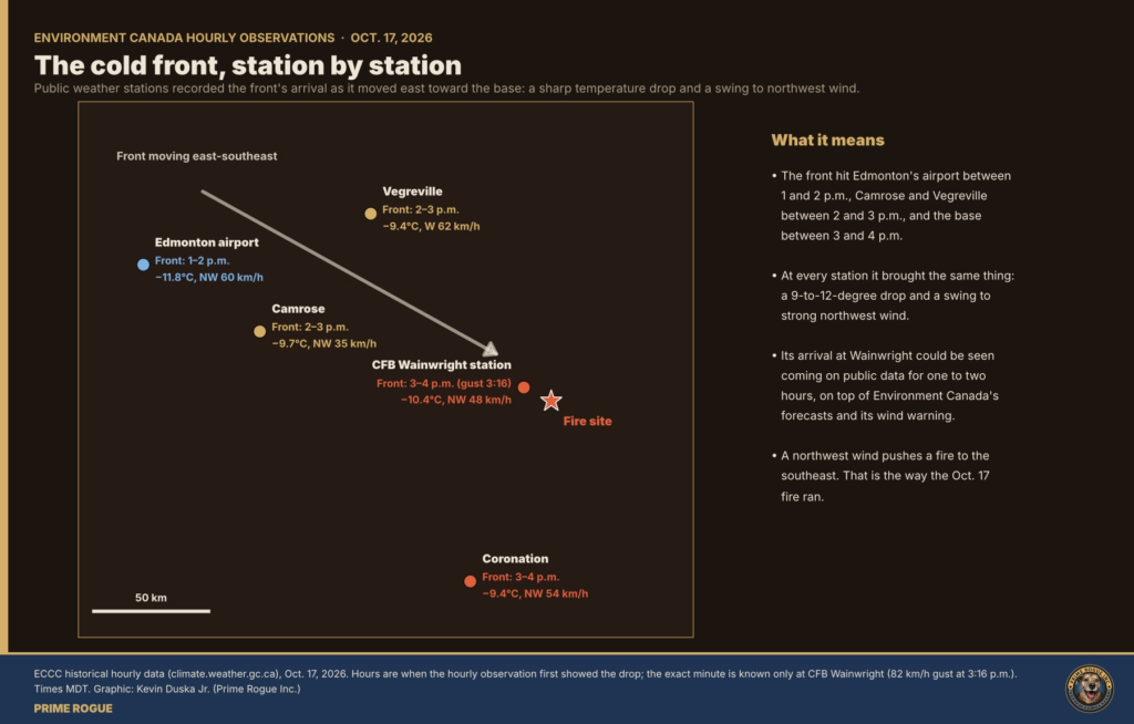
The fire crept north for at least three hours under a southwest wind. Then a forecast cold front swung the wind west, then northwest, and the fire’s long southeast side became its front. All times are Mountain Daylight Time.
| Time | What the record shows | Source |
|---|---|---|
| Oct. 12 | Last rain at the base | Environment Canada |
| 4:30 a.m. | Forecast for the area: west wind 50 km/h gusting to 80 “this afternoon” | Environment Canada forecast |
| 10:48 a.m. | Same forecast reissued | Environment Canada |
| 1 p.m. | Fire Weather Index at the base 30.8: “Extreme” on Alberta’s scale | Natural Resources Canada (CWFIS) |
| 12:17 p.m. | Landsat 8 records 59 fire detections in a line about 1.9 km long on the range, running southwest to northeast | NASA FIRMS |
| 1–2 p.m. | The front reaches Edmonton International Airport | Environment Canada stations |
| 1:30 p.m. | Dust storm warning upwind, Vegreville to Camrose: 100 km/h gusts, “near zero visibility” | Environment Canada |
| 2 and 3 p.m. | At the base: 23 °C, humidity 16–17%, southwest wind 30–32 km/h, gusts to 46–51 | Environment Canada, CFB Wainwright station |
| 2–3 p.m. | The front reaches Camrose and Vegreville | Environment Canada stations |
| 2:14 p.m. | Wainwright added to a wind warning: gusts to 100 km/h, a line of storms | Environment Canada |
| 2:49 p.m. | NOAA-20 records eight fire pixels; the fire has grown about 1 km north since 12:17, one detection inside the area mapped as Range 3 | NASA FIRMS |
| 3:05 p.m. | Wind warning kept for Wainwright, ended elsewhere | Environment Canada |
| 3:10 p.m. | GOES-18 flags fire at the north end of the area: 76 MW | NOAA |
| 3:16 p.m. | An 82 km/h gust from the west at the base’s weather station; by 4 p.m. the wind is northwest | Environment Canada |
| About 3:20–3:35 p.m. | The front reaches the fire, about 13–15 km east-southeast of the station | Prime Rogue estimate |
| 3:30 p.m. | GOES-18: 1,215 MW across three pixels, including one about 4 km south-southeast; 16 times the total of 20 minutes earlier | NOAA |
| 3:40 p.m. | GOES-18: only the southern pixel, 336 MW | NOAA |
| About 4 p.m. | Fire “reported” (National Defence). At the station: northwest 48–51 km/h, 12.9 °C, humidity 43% | DND; Environment Canada |
| 4:58 p.m. | First STARS air ambulance on public tracking leaves Edmonton | adsb.lol |
| Oct. 17 evening | Municipality: fire crossed the base fence, burning south of Township Road 44-0 | MD of Wainwright |
| Oct. 18, 2:12 and 2:32 p.m. | Satellites still detect heat in the burn’s east lobe, outside the base | NASA FIRMS |
| Oct. 19 | Sentinel-2 maps a 10.8 km² burn running 6.2 km to the southeast | Copernicus |
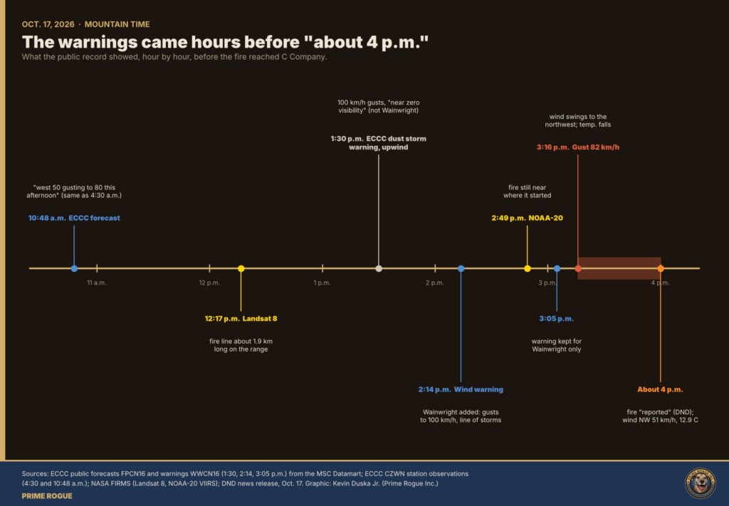
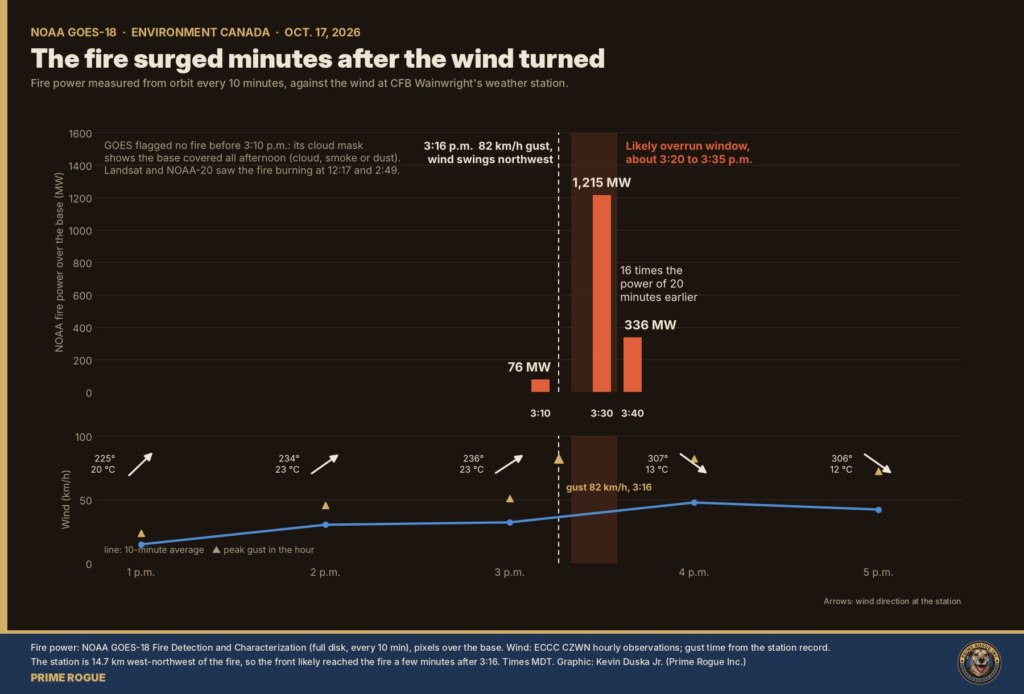
GOES-18 flagged no fire before 3:10 p.m. Its cloud mask shows the base covered all afternoon, by cloud, smoke or dust, so that absence does not mean no fire. Landsat and NOAA-20 had already seen it.
Take Rutland’s distance at face value, and the satellite data puts C Company in one place: the area around the grenade range and a north–south range road, about a kilometre southeast of where the fire stood when the wind turned.
National Defence has not said where on the 609 km² base C Company was training. Prime Rogue reconstructed it in four steps:
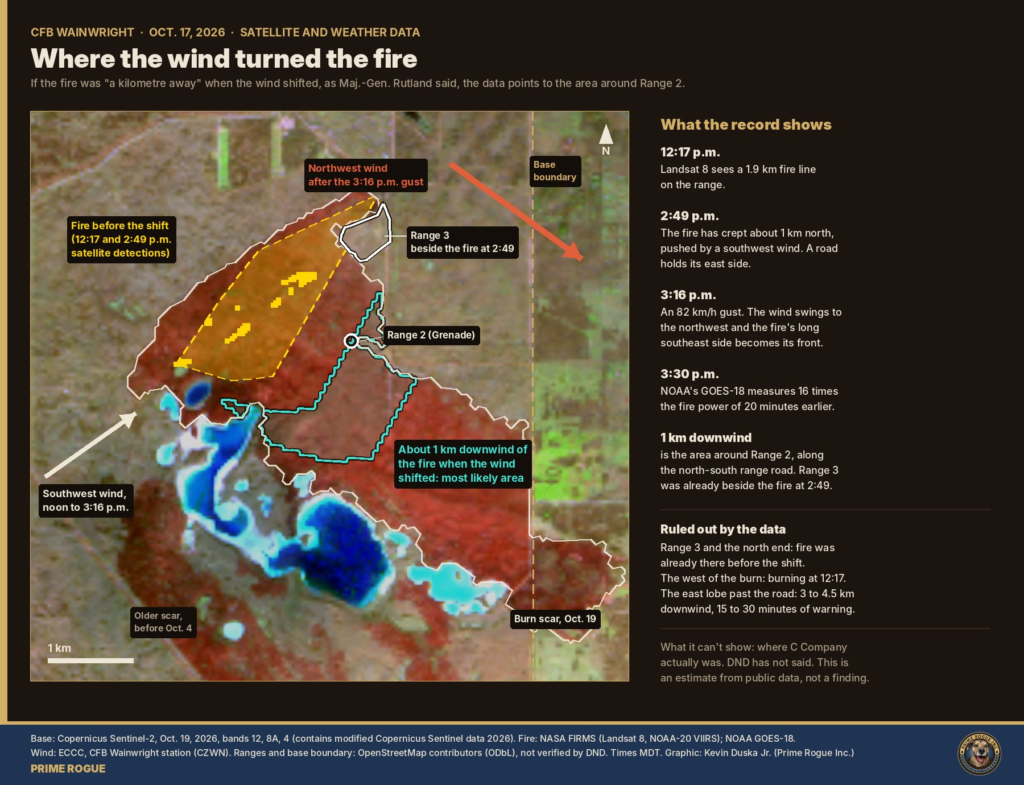
The result. About 1 km downwind lies a band of burned ground between the north–south range road near 110.90° W and the north shore of Jamieson Lake, at roughly 52.760–52.775° N. Most of it is around the spot OpenStreetMap labels “Range 2 (Grenade)”. That is where we judge C Company most likely was.
Three things fit the official account closely:
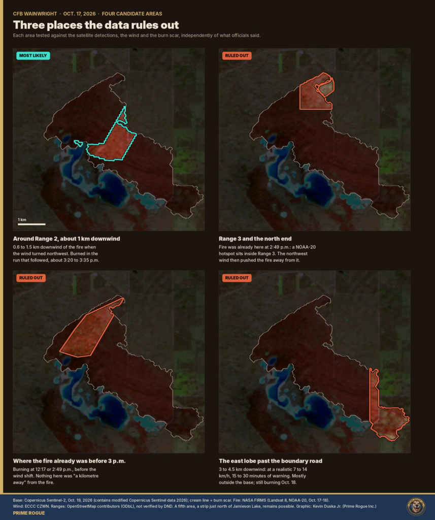
What the data rules out.
A view from the road. Calgary-based independent reporter Sydney Fizzard (@SydFizzard, thefizz.ca) filmed the burn by drone from Township Road 441, east of the base. His flight log, which he shared with Prime Rogue, puts the drone’s takeoff at 52.7707° N, 110.8684° W, about 440 m outside the base boundary and outside the restricted area marked on his flight app. He held the drone in one spot, about 25 m up, panning and zooming.
From there, the building at the burn’s edge is 1.9 km due west, down the east–west track to the boundary road, and the mapped grenade range is 2.6 km away on almost the same line. Jamieson Lake lies 3.8 km to the southwest. His camera was looking straight into the most likely area. Prime Rogue has not published his footage, which is his to license; we encourage readers to support his work and buy his photos at thefizz.ca.
Stress test. We repeated the analysis across 18 combinations of wind direction (270° to 325°) and of how much the fire might have grown between 2:49 and 3:16 p.m.
| Fire growth before the shift | Share of the 1 km band around Range 2 and the lake strip | Share in the ruled-out areas |
|---|---|---|
| None (as detected) | 91–100% | 7% at most |
| 400 m | 69–86% | 0% |
| 800 m | 27–53%; the rest shifts south toward the centre of the run | 0% |
The ruled-out areas stay ruled out in every combination. The estimate’s one weak point is fire growth: 800 m would shift the likely area about 1 km south. The fire models rule that out: even burning freely, the fire’s side could have crept only 200 to 320 m in those 27 minutes.
Our ranking:
| Area | Likelihood |
|---|---|
| Around Range 2 and the north–south range road | Likely, 55–70% |
| Strip north of Jamieson Lake, next to it | Unlikely but credible, 15–25% |
| South-central part of the run | Very unlikely, 5–15% |
| Just outside the burn at its northeast edge (overlaps the Range 2 area) | Very unlikely, 5–10% |
| East lobe past the boundary road | Remote, under 5% |
| Range 3 and the north end | Remote, under 5% |
| Where the fire already was | Remote, under 3% |
Three standard grass fire models, fed the base’s own weather readings, agree: after the wind turned, the fire covered a kilometre in five to 14 minutes, not 30 to 60 seconds.
The models: the Canadian Forest Fire Behavior Prediction System, used by Canadian fire agencies, for matted and standing grass; the CSIRO grassland model (Cheney, Gould and Catchpole, 1998), for natural and grazed pasture; and the Cruz et al. (2022) rule that grass fires spread at about 20% of the wind speed. Inputs: Environment Canada’s readings at the base, Prime Rogue’s hourly fine-fuel moisture code (92.3–92.9), computed from Natural Resources Canada’s daily value of 91.8, and grass 90–100% cured.
| Period | Wind (km/h) | Head spread (km/h) | Minutes per km | Fireline intensity (kW/m) |
|---|---|---|---|---|
| Before the shift, 2:49–3:16 p.m. | 32, southwest | 4.8–7.8 if burning freely | 8–12 | 7,200–15,500 |
| After the shift | 48, northwest | 4.4–12.0 | 5–14 | 6,500–21,000 |
| In the 82 km/h gust | 82 | 7.8–16.4 | 4–8 | 11,800–28,000 |
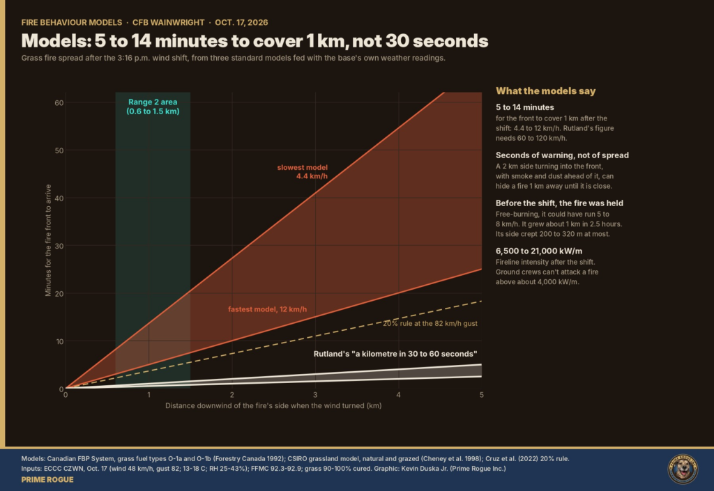
The models assume continuous grass; aspen clumps, wetlands, grazing and roads slow real fires, so the true speed may sit at the lower end. Either way, the gap with 30 to 60 seconds is five- to 27-fold.
By 3 p.m. on Oct. 17, five facts were on the record, and each pointed the same way.
Against that, the training was routine. C Company was throwing grenades and practising a section attack, foundational infantry skills, for a deployment to Latvia reported for April and May. The only rationale in Rutland’s reported remarks was: “We train in all types of conditions, because you don’t know where you’re going to operate.”
Wildland fire crews are trained to recognize a short list of “watch out” situations, and to withdraw when they stack up. Three were present that afternoon: the wind forecast to change direction, unburned grass between the troops and the fire, and a main fire that could not be seen once smoke and dust blew ahead of it. Soldiers are not firefighters, but the hazard is the same.
Prime Rogue’s assessment: the warning signs were on the public record before training continued. And it is likely that the decision to continue exposed the soldiers to a risk out of proportion to its purpose. The drills could have been paused or moved for an afternoon at little cost.
What could change that assessment: the base’s range standing orders and fire-danger restrictions; range control’s logs; whether the 2:14 p.m. warning reached the range; what fire guards and suppression were in place; and what escape plan the admin area had. If they show controls we cannot see, the judgment weakens. If they show the warning never reached the range, or orders weren’t followed, it strengthens.
Read in full, the military’s own account points to the same place the data does. It breaks down only on timing, speed and distance from the training area.
| Statement | Who | The record | Holds? |
|---|---|---|---|
| Range control knew of a fire “for several hours” and let training “carry on” | Rutland | Fire on the range from 12:17 p.m., modest at 2:49 | Yes |
| “The fire was a kilometre away when the wind shifted” | Rutland | That kilometre falls around the grenade range in 13 of 18 model runs, and never at Range 3 or past the boundary road | Yes: it is the basis of our estimate |
| “They saw no fire, and then there was a fire right on top of them” | Commander on the ground, via Rutland | A 2 km side turning into the front, with smoke and dust ahead | Yes |
| Flames reached the range’s administrative area; the grenade range was not affected | Rutland, as reported by Postmedia | The mapped grenade range barely burned; the ground beside it burned hard | Yes |
| Fire reported or ignited “about 4 p.m.” | DND release; Rutland | Burning at 12:17 p.m. If 4 p.m. were the overrun, the front was then 4–6 km southeast, 15–60 minutes from anyone a kilometre away | Not as a start time |
| “A kilometre in 30 to 60 seconds” | Rutland | Models: 5–14 minutes. 30–60 seconds needs 60–120 km/h | No, as a speed; plausibly as warning time |
| “Far removed from the training area” | Carignan | Fire among the mapped ranges from midday, inside Range 3’s polygon at 2:49 | No |
| “Uncommon, rapid”; unexpected (memo, as reported) | CAF memo; Rutland | Forecast at 4:30 and 10:48 a.m.; warning at 2:14 p.m.; the front crossed Edmonton two hours earlier | No |
| Winds “well below 50” for most of the day | Rutland | True until 3 p.m. (gusts 46–51 km/h); then 82 km/h | Partly |
| A fire index that was low | CAF memo, as paraphrased | Fire Weather Index 30.8, “Extreme” | No |
| Crossed established fire guards | Rutland | The fire crossed the base boundary road to the east | Yes |
| Not oil and gas: “initial impression is it’s not” | Rutland | Nothing within 500 m of where the fire was first seen | Consistent |
Officials disagree with each other on one point: Rutland said the fire started within the training area, according to CBC, while Global News also reported him saying it did not start within the training area, and Carignan called it “far removed” from it.
Nothing in the energy records points to a gas ignition: the nearest pipeline was about 870 m, and the nearest well 1 km, from where satellites first saw the fire. But an operating gas line runs through the area where C Company most likely was.
The Wainwright training area is shared land. A 2014 Western Producer report described about 180 buried natural gas wells on the base, with pipelines buried twice the usual depth to withstand armoured vehicles; Global News cited a federal figure of more than 200 active gas wells in the area. Global News reported that unnamed military sources had raised the possibility of a gas line or well being hit. Rutland said: “Initial impression is it’s not, but we will definitely check.”
Prime Rogue mapped every Alberta Energy Regulator (AER) well licence and pipeline segment around the burn, along with NRCan’s CanVec wells and pipelines.
| Check | Result |
|---|---|
| AER well licences within 5 km of the burn | 109: 38 abandoned, 26 issued, 19 suspended, 17 reclaimed, 9 other |
| Wells inside the burn | 2, both in the east lobe: one abandoned, one reclaimed |
| Nearest well to the 12:17 p.m. fire line | 1.0 km, Sumerian Oil & Gas, licence issued |
| Nearest pipeline to the 12:17 p.m. fire line | 870 m, Sumerian Oil & Gas natural gas line, 89 mm, operating |
| Wells, pipelines, buildings or power lines within 500 m of where the fire was first seen | None |
| Operating pipeline in and within 150 m of the likely area | 1.24 km of Sumerian Oil & Gas natural gas pipeline |
| Well licences in the likely area | 1, Sumerian Oil & Gas, licence issued |
| Share of the burn’s edge that follows a pipeline | 2% (roads and tracks: 12%) |
What it means:
AER licence status shows only whether a licence is active, not whether a well produces. A well licensed for sour gas, with a low hydrogen sulphide content, lies about 300 m east of the likely area, near the east–west track to the boundary road.
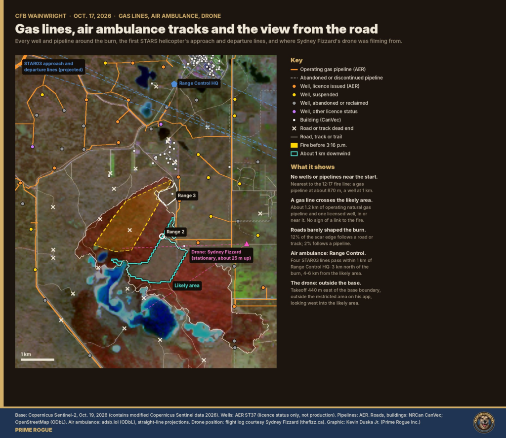
The first STARS helicopter on public flight tracking left Edmonton at 4:58 p.m., about an hour and a half after the fire most likely overran C Company, and appears to have landed near Range Control rather than at the scene.
Alberta officials said 30 emergency units went to Wainwright on Oct. 17: 22 ground ambulances and eight aircraft, six fixed-wing and two helicopters. Patients went first to the Wainwright Health Care Centre, then to hospitals in Edmonton, Calgary and Red Deer. Health agencies held their first coordinating call by 6 p.m. Code Orange was declared at several hospitals and lifted the next afternoon. Saskatchewan sent air ambulances.
Prime Rogue searched the adsb.lol open archive, which records aircraft position broadcasts, for every aircraft heard within about 60 km of the base from 10 a.m. Oct. 17 to 8 a.m. Oct. 18: 151 aircraft.
The gap between about 3:30 p.m. and the first STARS departure at 4:58 p.m. is a question for National Defence and Emergency Health Services Alberta: when was air support requested, and how were the wounded moved before it arrived?
These are straight-line projections from the last and first positions heard; a helicopter can turn out of coverage. Data: adsb.lol (Open Database License).
The same northwest wind carried the fire across the base’s eastern boundary road and onto farmland, where it was still burning the next afternoon.
An earlier scar south of the lakes predates Oct. 4 and is not part of this fire.
The data shows where the fire went and when. It cannot show where any soldier stood, what caused the fire, or what range control knew and did.
| Record | What it would settle |
|---|---|
| National Defence’s grid reference for the admin area and section-attack range, and its range numbering | Where C Company was; whether OpenStreetMap’s labels are right |
| Range control and radio logs, Oct. 17 | When the fire was first logged; when training stopped; whether the 2:14 p.m. warning was received |
| CFB Wainwright range standing orders and fire-danger restrictions | Whether continuing training complied with the base’s own rules |
| The briefing video and a full transcript | Rutland’s exact words on distance, timing and the grenade range |
| Air ambulance request and landing records | When help was called, and where the wounded were collected |
| High-resolution post-fire imagery | Vehicles, equipment or a staging area in the burn |
If any of these places C Company more than about 2 km from the north–south range road near the grenade range, our location estimate is wrong and we will say so.
Prime Rogue sent National Defence 10 questions at about 5:20 a.m. ET on Oct. 21, with a 7:30 a.m. ET deadline. They are condensed below. National Defence did not answer any of them. In an emailed reply before publication, Andrée-Anne Poulin of National Defence media relations wrote that the investigation “remains active, and commenting on specific details at this stage would be inappropriate. The Office of the Canadian Forces Provost Marshal will provide further updates on the investigation’s status and outcome when appropriate.” We will add any further response.
Every data file behind this analysis is public, unaltered, hashed and timestamped on the Bitcoin blockchain in Prime Rogue’s CFB Wainwright Fire Archive, so anyone can check the work.
| Data | What we used it for | Archive folder |
|---|---|---|
| NASA FIRMS fire detections (Landsat 8, NOAA-20, NOAA-21, Suomi NPP, MODIS) | Where and when the fire burned; 2012–2026 history | data/firms/ |
| NOAA GOES-18 and GOES-19 fire detection and imagery, every 10 minutes | Fire power and timing, 3:10–3:50 p.m. | data/goes/ |
| Copernicus Sentinel-2, Oct. 4 and Oct. 19 | Burn scar, by change in Normalized Burn Ratio (dNBR ≥ 0.27) | data/copernicus/ |
| Environment Canada forecasts, warnings and station observations | Wind, temperature, humidity, the front’s timing | data/eccc/, data/reference/ |
| Natural Resources Canada fire-weather index | Fire danger; inputs to fire models | data/nrcan_cwfis/ |
| Alberta Energy Regulator wells and pipelines; NRCan CanVec | Gas infrastructure, roads, buildings | data/infrastructure/, data/reference/ |
| OpenStreetMap | Range names and boundaries (unverified) | data/infrastructure/ |
| adsb.lol aircraft positions | Air ambulance tracks | data/adsb/ |
Location estimate. The fire’s position before the shift is the outline of the 12:17 and 2:49 p.m. detections, clipped to the burn. For each 50 m patch of burned ground, we measured the distance upwind to that outline along the post-front wind. The “kilometre away” band is 0.6 to 1.5 km. Seven candidate areas were scored with the Analysis of Competing Hypotheses method (Heuer), by a Prime Rogue analyst working independently of our first estimate, and stress-tested across 18 combinations of wind direction and fire growth.
Fire models. Canadian FBP System fuel types O-1a and O-1b (Forestry Canada, 1992; Wotton et al., 2009); CSIRO grassland model (Cheney, Gould and Catchpole, 1998), natural and grazed; Cruz, Alexander and Kilinc (2022). Hourly fine-fuel moisture by Van Wagner’s (1977) method from Natural Resources Canada’s daily value.
Air ambulance tracks. Positions broadcast by aircraft and collected by volunteer receivers. Arrival and departure lines are straight-line projections from the last and first positions heard.
Probability language. Estimative terms follow the scale in our key judgments. Confidence reflects the quality of the evidence.
Licences. Prime Rogue’s analysis and graphics: CC BY-NC 4.0. Code: MIT. Copernicus: contains modified Copernicus Sentinel data 2026. NASA and NOAA data: public. Environment Canada and NRCan: Open Government Licence – Canada. OpenStreetMap and adsb.lol: Open Database License.
Have something? Send documents or information through Signal (Rubicon49.50) or Proton email via kevinjr.duska (at) proton (dot) me. Do not use GitHub for tips; its history is public and permanent.
These deaths were highly likely preventable.
The fire did not appear from nowhere. It had been burning on the range since at least 12:17 p.m., and range control knew of it for hours. The wind that drove it onto C Company was forecast before dawn, forecast again before 11 a.m., and named in a warning at 2:14 p.m., about an hour before it arrived. Fire danger at the base was rated “Extreme.” The training was routine, and could have been stopped or moved for an afternoon.
We cannot yet say who failed. If range control and the chain of command had this information and kept training, the failure was one of judgment. If the information never reached them, the failure was in the system meant to deliver it. Either way, the outcome was the same: four soldiers dead and 39 people in hospital, from a hazard that was visible in public data before it struck.
The military’s own account, read closely, supports this judgment. A fire it had monitored for hours, a kilometre away, turned with a forecast wind and reached a range admin area. What it does not explain is why the training was still there when it did.
Three investigations are under way. Their findings should answer what this analysis cannot: what range control knew, what its rules required, and why C Company was still downwind when the wind turned. Prime Rogue will publish every record it obtains.
This assessment is based on public data and is stated in calibrated probability. It is not a finding of criminal or civil fault against any individual.
Official statements and reporting
Data
Science
Prime Rogue
 Every Warning Light Was On: What Most Likely Happened at CFB Wainwright
 Wainwright Deaths: Alberta Says its Death Investigators Have Jurisdiction on the Base
 Satellite record fits scenario that an exercise fire was burning before the CFB Wainwright incident
 DND said the Wainwright fire “ignited” at 4 p.m. The military now says it was known for hours


[…] accounts can be reconciled. Alberta law makes every RCMP officer a medical examiner’s investigator, so the same Mounties can serve both the military police and the OCME. But no official has said […]
[…] a baseline that captures every type of peacetime military death across approximately 68,000 active personnel spread across Canada and multiple deployments […]
[…] Quebec remains the only province in Canada whose police watchdog does not publish its final investigation reports. British Columbia does. Ontario does. Manitoba does. Nova Scotia does. Quebec does […]
[…] and — in a detail that has received insufficient attention — the development of an independent Alberta military, with specific discussion of whether the US would be willing to help Alberta build that […]
[…] intelligence reveals a pattern: every time Trump threatens Greenland, operations at Canada’s northernmost military installation intensify. Yesterday’s flight is just the […]