Address
304 North Cardinal St.
Dorchester Center, MA 02124
Work Hours
Monday to Friday: 7AM - 7PM
Weekend: 10AM - 5PM

Address
304 North Cardinal St.
Dorchester Center, MA 02124
Work Hours
Monday to Friday: 7AM - 7PM
Weekend: 10AM - 5PM
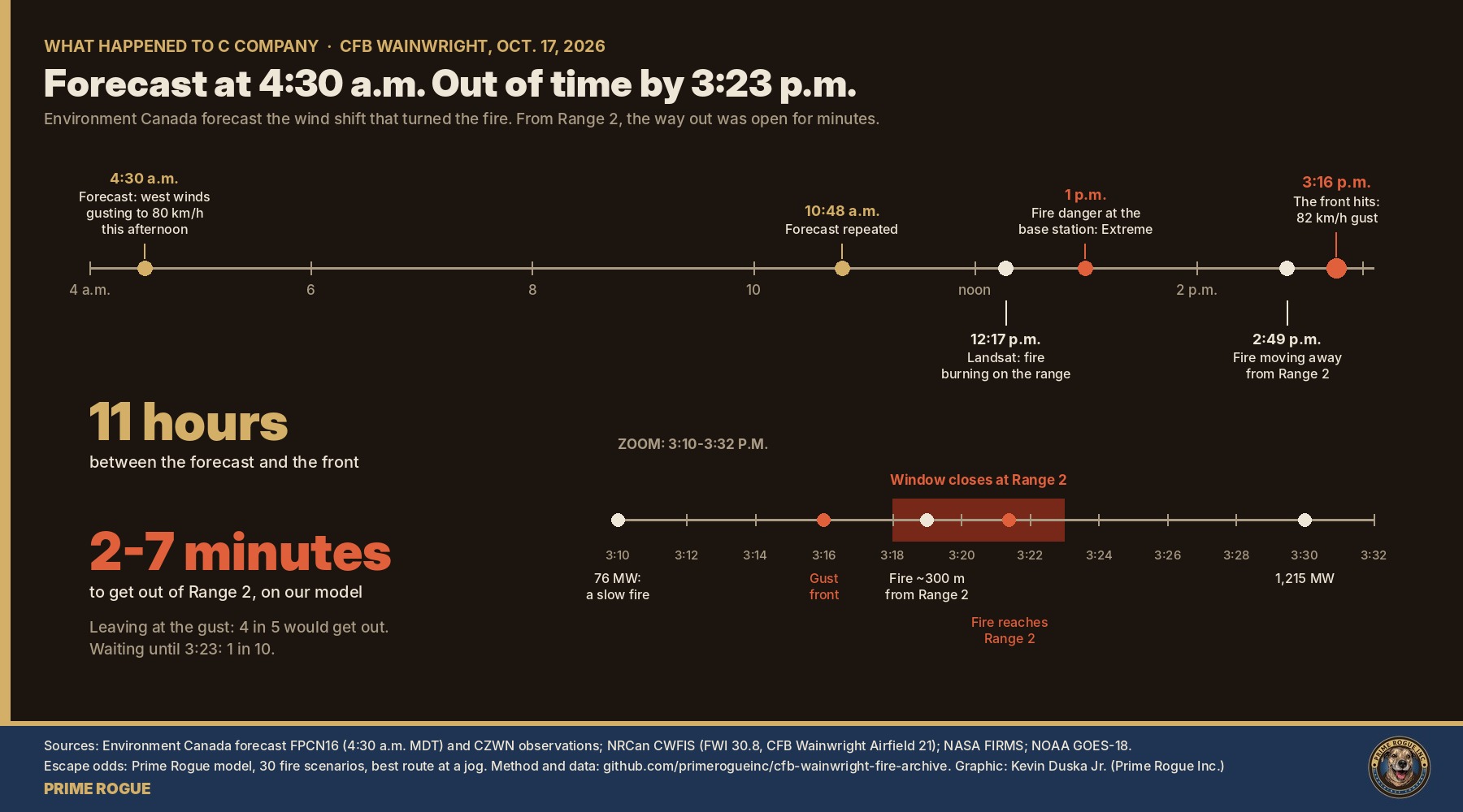
At 4:30 a.m. on Oct. 17, Environment Canada forecast west winds gusting to 80 km/h for the Wainwright area that afternoon. At 2:14 p.m., it issued a wind warning for Lloydminster-Wainwright: gusts up to 100 km/h expected that afternoon. At 3:16 p.m., an 82 km/h gust hit the base. The wind swung behind a grass fire that had been burning on the training area since at least midday, and turned its slow southeastern side into a running front aimed at the ground where we estimate C Company was.
The soldiers were from C Company, 3rd Battalion, Princess Patricia’s Canadian Light Infantry, CBC News reported. Four were killed: Sgt. Morgan Wong and Ptes. Shaun Farrell, Aidan Goulding and Hayden Lykkemark. Thirty-nine were hurt. As of Oct. 22, Premier Danielle Smith said 27 remained in hospital, 13 in critical condition; DND said 12 had been released.
Over the past two days we put our Oct. 21 analysis through six stress tests in public: wind, distance, terrain, escape, visibility and the fire’s position. The conclusion held each time.
What we found
| Finding | Confidence |
| C Company was within about 1 km downwind of the fire’s edge, in the area around Range 2 and the end of the range road as mapped | High (80-90%) for the area; DND has not confirmed which range |
| The fire reached them after the 3:16 p.m. wind shift | High (~90%) |
| From where they stood, there was little sign of danger until minutes before the fire arrived | High (80-90%) |
| Once the fire itself was the warning, there was too little time to get out | High (80-90%) |
| The wind shift was forecast about 11 hours ahead and warned of about an hour ahead, on a day of Extreme fire danger | Fact, from public records |
| The failure lies in situational awareness on the range, its communication to the troops, or both | Moderate-high (70-75%) |
| Any alternative we tested clears the chain of command | None does |
Three investigations are under way: the Canadian Forces National Investigation Service, with the RCMP and Alberta’s medical examiner; the Canadian Forces Fire Marshal; and a Board of Inquiry, which DND says typically takes nine to 12 months. Gen. Jennie Carignan, the Chief of the Defence Staff, has said she intends to make its findings public. Until then, DND has declined to comment on specifics. It holds every record that could test what follows.
At the Oct. 22 briefing, officials confirmed the core of our reconstruction. Every statement matches the satellite and map data.
| Officials said | Our data |
| The fire was reported on the automatic grenade launcher range | Our earliest detections, at 12:17 p.m., cluster inside the danger area about 1.1 km west-northwest of Range 2 |
| It initially stayed inside Permanent Danger Area 2, so firefighters could not attack it directly | All 59 noon detections, and the whole fire outline before the wind shift, sit inside PDA 2 as publicly mapped. After the shift it broke out: 9% of the final burn lies outside |
| Range control monitored the fire throughout the day | Satellites show it burning from about noon. DND’s Oct. 17 news release had said it ignited about 4 p.m. |
| The grenade launcher range and the section-attack range are two separate ranges | They sit about 1.1 to 1.6 km apart on our data, matching Rutland’s “a kilometre away when the wind shifted” |
| The sudden wind change increased the fire’s speed and spread | Fire power rose from 76 MW at 3:10 p.m. to 1,215 MW at 3:30 |
| No indication natural gas infrastructure was involved | No producing gas wells within 2 km; no mapped pipelines within 500 m |
| The weapons-effect simulation and tracking system (WEST) was not in use | No automatic record of soldiers’ positions is likely to exist |
Officials said questions about the terrain would be addressed by the investigation. They did not dispute our location.
We re-ran all six parts of the model after the briefing. Every result reproduced exactly. We then added what officials told us as a constraint, and it narrows the location.
Administrative areas sit outside danger areas. Of the 10.8 km² that burned, only about 1 km² lies outside PDA 2 as publicly mapped, and almost all of it is one patch at the far southeastern tail, 4.8 km from where the fire started. That is far too far for “a kilometre away when the wind shifted.” The only other burned ground outside PDA 2 is a thin strip along its eastern edge, beside the road head at the end of the range road, in a hollow below the rise. Taken together, the officials’ statements point to that spot. Soldiers on the attack lane itself could have been further forward, inside the danger area toward the rise. This is our inference from public maps, which DND has not confirmed.
It also changes the question that matters. Range control could see the fire all day, but the fire burned for hours in an area where firefighters could not go. Once a wind shift was forecast to drive it out of that area, the only safe move was to pull people back from its edge.
This is our reconstruction, not an account from anyone who was there. Each step rests on the evidence noted beside it, and DND can confirm or correct any of it. Where we do not know something, we say so.
At 4:30 a.m., Environment Canada forecasts west winds gusting to 80 km/h for the Wainwright area that afternoon. The day’s fire danger at the base will reach Extreme. Training goes ahead. (Public forecast and fire-weather records. That training went ahead is a fact; who decided, and on what information, is not public.)
By 12:17 p.m., satellites detect a grass fire northwest of Range 2. Through the early afternoon a southwest wind pushes it slowly northeast, about 0.45 km/h, away from the ground where we estimate C Company was. Maj.-Gen. Wade Rutland, commander of 1st Canadian Division, has said range control knew of the fire “for several hours.” From the range, it would have looked like smoke off to one side, heading elsewhere. (NASA satellite detections; part 6; Rutland, Oct. 18 briefing. DND’s Oct. 17 news release gave the ignition as about 4 p.m.; satellites show fire on the base from about noon, and DND has not said whether these were the same fire.)
Environment Canada issues a yellow wind warning for Lloydminster-Wainwright-Vermilion-Provost: “wind gusts up to 100 km/h are expected this afternoon,” with high forecast confidence. The front is about an hour away. (ECCC warning bulletin, archived in our repo.)
The fire had started on the automatic grenade launcher range, inside Permanent Danger Area 2. Because of the danger area, firefighters could not attack it directly, so it burned on while range control watched. C Company was training on a separate section-attack range, about a kilometre away. Officials said the fire later overtook that range’s administrative area, where soldiers wait their turn, ready their kit and park vehicles. The likeliest spot on public maps is the road head at the end of the range road: a hollow just outside the danger area, below a rise to its west. Soldiers on the attack lane itself would have been further forward, moving in short rushes and dropping prone. The weapons-effect simulation and tracking system was not in use, so no system was recording where each soldier was. (Oct. 22 briefing; Rutland, Oct. 18; CTV/CP24, Oct. 22. Danger-area boundary and range names: OpenStreetMap, unconfirmed by DND. Sightlines: parts 3 and 5.)
The cold front hits the base weather station with an 82 km/h gust. Within minutes the wind swings to the northwest, behind the fire. The fire’s slow southeastern side becomes its front and starts running at 4.4-12 km/h, our central estimate 8 km/h, toward ground about 430-480 m away. From behind the rise, what soldiers could most likely see was a darkening smoke column and a sudden gale, not flames. (Weather station records; parts 1, 3 and 6. The station is about 15 km west of the fire, so the front may have reached the fire up to about 10 minutes later.)
3:16-3:19 p.m.: the minutes that mattered. This is when an order to move would have worked best. On our model, troops leaving the Range 2 area at the gust reached safe ground about four times in five, heading east across the wind. But a company on a range does not scatter on its own: it stops, accounts for its people, makes weapons and ammunition safe, and waits for direction. Disaster research finds that is what people do in fires. Each minute spent that way cost about a tenth of the chance to get out. If the fire ran at the faster end of our estimates, it cost more: a three-minute wait left about one chance in seven. (Part 4; behaviour research. Whether an order came, and when, is unknown.)
With the fire about 300 m out, flames come into view, likely through thickening smoke. Anyone who starts moving now has about two and a half minutes, against a fire moving about as fast as they can jog. (Parts 3, 4 and 5; smoke is modelled.)
Some soldiers get out, most likely by moving east across the wind or by getting through the flames onto ground that had already burned. Public images of the injured show mostly lower-limb injuries, which fits brief contact with low flames at the fire’s side or a thin front, rather than being caught by its head while fleeing downwind. Four people did not survive. We do not know where or how each of them was caught, and we will not speculate. (Part 4; public images reviewed in aggregate and not published.)
Casualties reach the Wainwright Health Centre in military vehicles. The Globe and Mail described a military truck pulling up and a soldier limping in on burned legs. The injured were later moved to hospitals in Edmonton, Calgary and Red Deer. (News reports; public images reviewed in aggregate and not published.)
Nothing in this sequence required the soldiers to make a mistake. It required only that the decision to move them was not made, or did not reach them, before the fire could be seen.
On Oct. 22, X user @AuthenticStoic challenged our analysis. Their case: the wind at the front came from the west, not the northwest, so the fire should have run east and our location estimate was suspect. They also asked about terrain: “Running away in flatlands is a lot easier than running away uphill.”
Those were fair questions, so we turned them into a public stress test, run part by part on X and named for the person who asked. Each part attacked one assumption the analysis rested on. Every script, input and result is in our open CFB Wainwright fire archive on GitHub, so anyone can rerun it.
We changed our work where the tests said to. Part 1 led us to withdraw one satellite reading. Part 6 moved the fire’s edge about 100-150 m closer to Range 2 than we first assumed. Neither changed the conclusion.
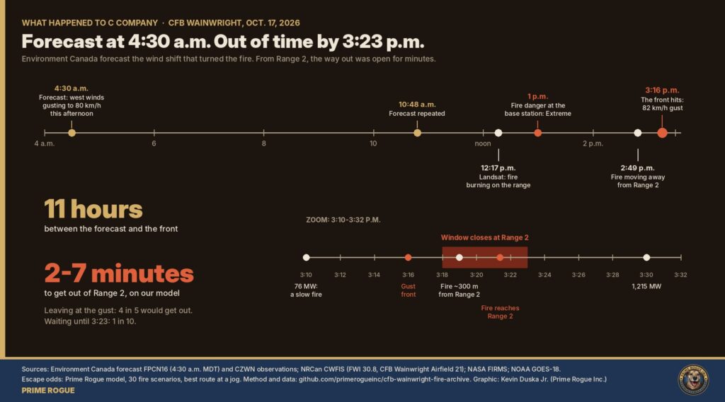
The wind shift was in the public forecast before dawn and in a formal warning an hour ahead. On our model, the escape window in the Range 2 area lasted about two to seven minutes after the front arrived. Observed times come from satellites and weather stations; modelled times come from the six parts below.
Modelled times assume the front reached the fire at 3:16 p.m., when it hit the base weather station about 15 km to the west. Fitting the front’s passage at four stations (Edmonton about 1:27 p.m., Red Deer 2:24, the base 3:16, Lloydminster 3:49) gives a front moving southeast at about 80 km/h. At that speed it would reach the fire around 3:26. The fit is loose, and satellite data favour the earlier end, so our bracket is 3:16 to about 3:26. If the front arrived later, every modelled time below shifts later by the same amount. The minutes between the gust and the fire’s arrival do not change. That is also why our Oct. 21 analysis gave a wider window of about 3:25-3:45 p.m. for the fire reaching the troops.
| Time (MDT) | What happened | Basis |
| 4:30 a.m. | Environment Canada’s scheduled 5 a.m. forecast, transmitted at 4:30, calls for wind “southwest 30 km/h gusting to 50 this morning then west 50 gusting to 80 this afternoon” for Lloydminster-Wainwright-Vermilion-Provost | Observed (forecast bulletin) |
| 10:48 a.m. | The forecast is reissued, still calling for west winds gusting to 80 km/h in the afternoon | Observed |
| About noon | NASA satellites detect fire on the base; Landsat maps it at 12:17 p.m., northwest of Range 2 | Observed |
| 1 p.m. | The base’s own weather station gives a Fire Weather Index of 30.8: Extreme on Alberta’s scale | Observed |
| About 1:27 p.m. | The front crosses Edmonton International Airport, about two hours upwind | Observed |
| 2 p.m. | Wind at the base: 30 km/h from the southwest, gusts to 46 km/h, humidity 16% | Observed |
| 2:14 p.m. | Environment Canada issues a wind warning for Lloydminster-Wainwright: gusts up to 100 km/h expected this afternoon | Observed (warning bulletin) |
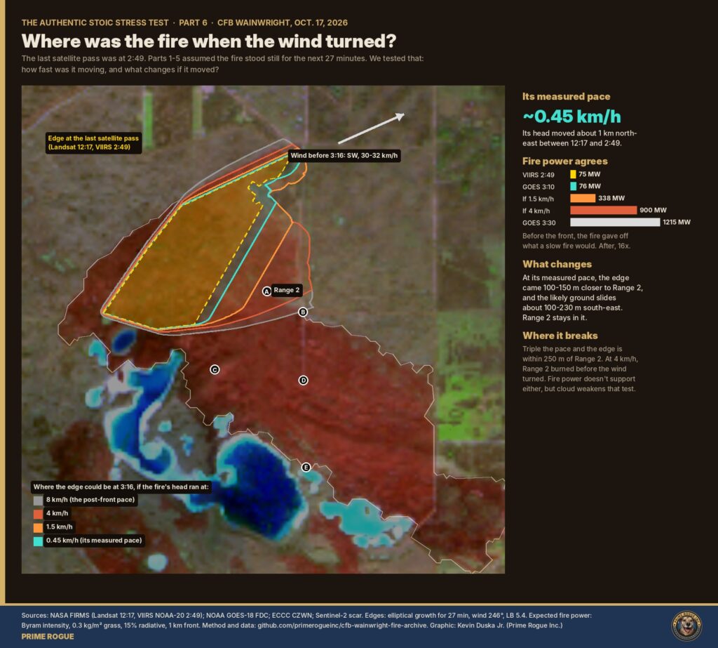
| 2:49 p.m. | VIIRS maps the fire’s edge. Its head is moving northeast, away from Range 2, at about 0.45 km/h | Observed |
| 3:00 p.m. | Wind at the base: 32 km/h from the southwest, gusts to 51 km/h, humidity 17% | Observed |
| 3:10 p.m. | GOES-18 measures 76 MW of fire power: a slow fire | Observed |
| 3:16 p.m. | The front hits the base station. Peak gust 82 km/h; the wind swings to the northwest. The fire’s edge is about 430-480 m from Range 2 | Observed / modelled |
| 3:18-3:23 p.m. | Latest departure from the Range 2 area that still reaches safe ground at a jog | Modelled |
| About 3:21 p.m. | Fire reaches the Range 2 area (range 3:19-3:26; road’s end about 3:26) | Modelled |
| 3:30 p.m. | GOES-18 measures 1,215 MW, 16 times the level 20 minutes earlier | Observed |
| Afternoon | Casualties reach the Wainwright Health Centre in military vehicles | News reports |
The challenge was right that the first gusts came from the west. It was wrong that this sent the fire east for the next hour, and the location held either way.
We ran a fire-spread model 30 ways: five wind schedules, from a fixed 306° to @AuthenticStoic’s slow veer from 269°, at three spread rates and two front-arrival times. Then we compared each result with the burn scar mapped by the Sentinel-2 satellite on Oct. 19.
We also withdrew one reading of our own. A GOES-18 heat pixel east of the fire, which we had read as a sign of an eastward run, contains no burned ground at all. Its heat was blur from the fire next to it.
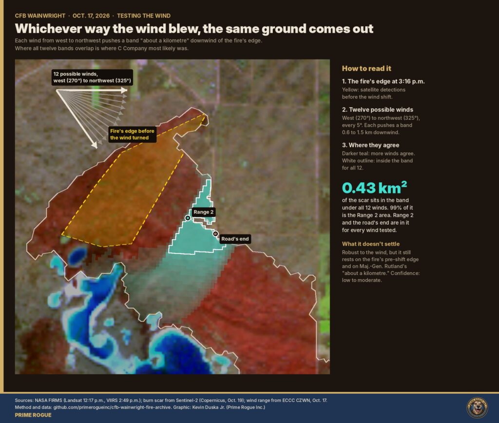
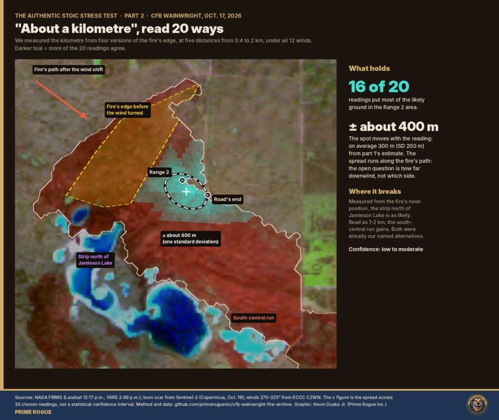
Maj.-Gen. Wade Rutland, commander of 1st Canadian Division, told the Oct. 18 briefing that “the fire was a kilometre away when the wind shifted.” He did not say a kilometre from what. However we read that phrase, most readings land on the area around Range 2, give or take about 400 m.
A kilometre depends on what it is measured from. We measured it from four versions of the fire’s edge: the full outline at the last satellite passes, the latest pass alone, the noon pass alone, and the fire’s main body. We read it five ways, from a tight 0.75-1.25 km to a loose 0.4-2 km, under all 12 winds.
The ground was gentle, but a low rise sat between the fire and most of the likely ground. From much of it, a standing soldier could not see the fire’s edge.
We used Natural Resources Canada’s 30 m elevation model. The burned area spans about 40 m of relief, 650-690 m above sea level, with slopes typically 2-3°. That rules out the steep-terrain “blow-up” seen in mountain fires: slope barely changed how this fire spread.
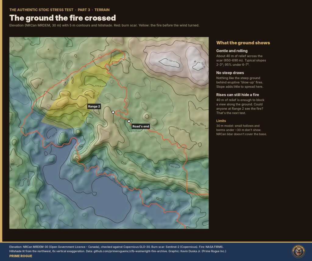
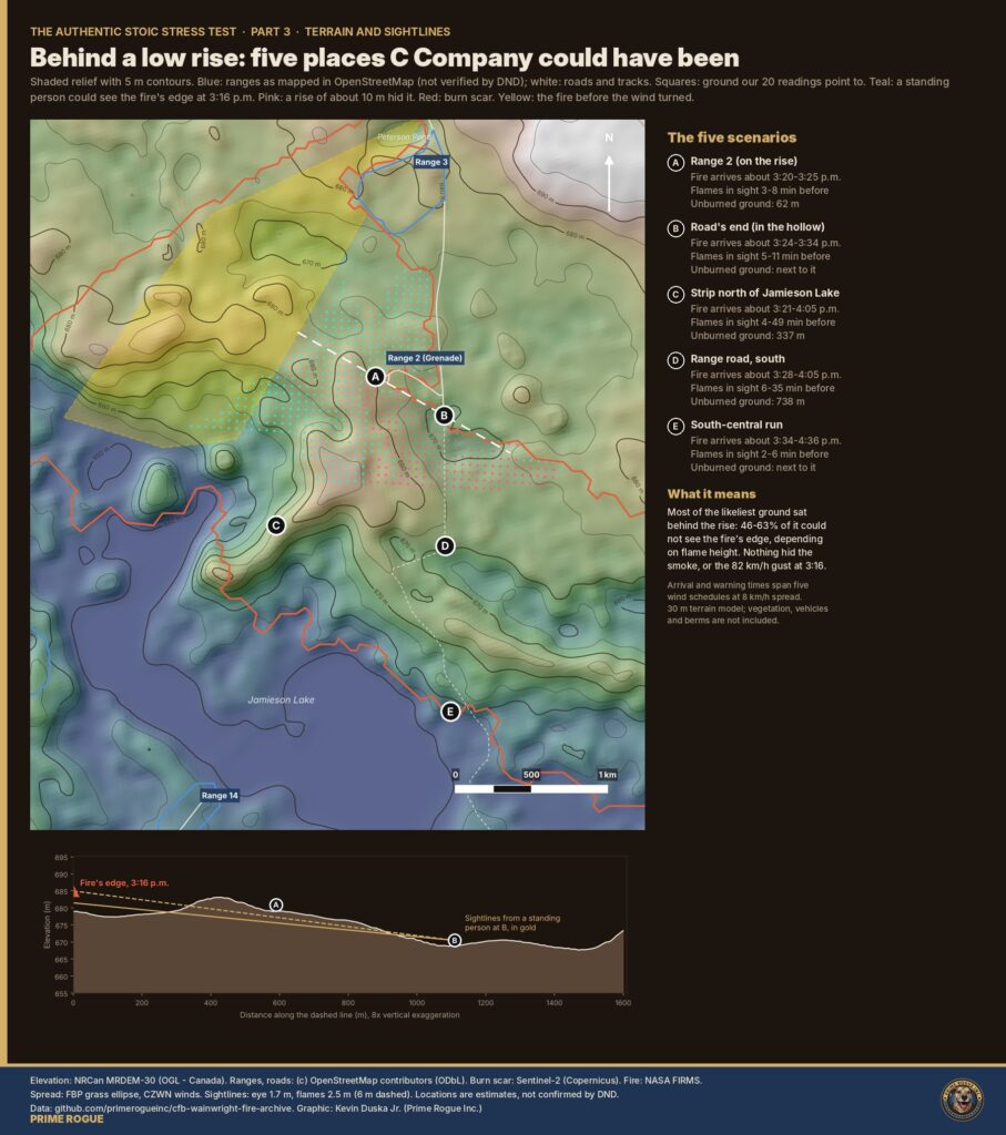
It changed what people could see. A ridge of about 680 m runs south from Range 2, with a shallow hollow east of it at the end of the range road. We traced sightlines from eye height to the fire’s edge before the wind turned. From 46-63% of the likeliest ground, the edge was out of sight.
We then tested five specific places C Company could have been:
| Place | Fire arrives (about) | Flames in sight before arrival |
| A. Range 2, on the rise | 3:20-3:25 p.m. | 3-8 min |
| B. Road’s end, in the hollow | 3:24-3:34 p.m. | 5-11 min |
| C. Strip north of Jamieson Lake | 3:21-4:05 p.m. | 4-49 min |
| D. Range road, south | 3:28-4:05 p.m. | 6-35 min |
| E. South-central run | 3:34-4:36 p.m. | 2-6 min |
At the two likeliest places, flames came into view only minutes before the fire did.
@AuthenticStoic asked whether the troops could simply have run half a mile east. On our model, yes, if they set off when the gust hit. Every minute they waited after that cost about a tenth of their chance.
We modelled escape routes in 72 directions from each of the five places, against 30 versions of the fire. We varied pace (a jog in kit, a walk, slowed by smoke, helping someone injured), the cue to move (the gust, flames in sight, fire within 300 m) and the delay after it (0-10 minutes). A route counted only if it reached safe ground with three minutes to spare: outside the burn, or ground that had already burned out.
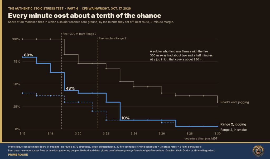
In plain terms:
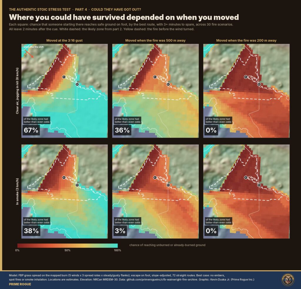
This is a best case. It assumes straight routes, perfect knowledge of the way out, no time spent gathering people or vehicles, and no embers or spot fires ahead of the front. Disaster research has found for decades that people rarely panic in fires. They look for information, gather with their group and wait for direction (Sime, 1984). A unit on a range waits for orders. On this model, that ordinary wait was enough to close the window.
Trees hid nothing: the likely ground is open grass. The ground itself hid the fire, and smoke probably closed in on the rest.
We tested the three things that can hide a fire, using canopy-height and land-cover maps, the elevation model, weather records and a smoke-plume model.
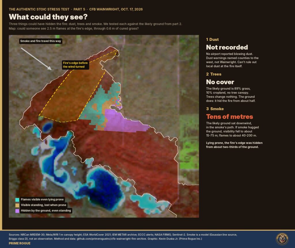
People on those ridges could probably see the smoke column rising. What they could not see was the flames coming toward them, until they were close.
Before the front, the fire was slow and moving away from Range 2. That is part of why nothing looked urgent from the ground.
The last satellite pass before the front was at 2:49 p.m. Parts 1-5 assumed the fire stood still for the next 27 minutes, so we tested that.
Put the six parts together and five conditions stack up. Each alone would have delayed a reaction. The first four are measured, not modelled.
Behind the rise, with the fire hidden and no warning, they had no way of knowing they needed to move until there was no time left to do it. Soldiers react to what they can see or are told. What they could see came too late. The decision that would have saved them had to be made before the fire was visible, on the forecast, by people who could see the whole picture.
The decision that mattered had to be made before 3:16 p.m., and it was not the soldiers’ to make. Under CFB Wainwright’s Range Standing Orders, as reported by Global News, “the initial decision to cease or modify training rests with the Chain of Command,” and the “final decision to curtail activities rests with the base commander.” Range control monitors what is happening across the training area. Soldiers train where they are told and move when they are told.
Those roles had what the troops did not.
On that information, a pullback before 3:16 needed no flames in sight. On our model, troops at Range 2 who moved at the gust itself had a 70-80% chance of reaching safety; at the road’s end, nearly 100%. Moving them before the gust would have needed no model at all.
That leaves two ways it could have failed, and both sit above the troops:
We do not yet know which, or who knew what and when. What the evidence establishes is that the moment to act came hours before the fire could be seen from the ground. Nobody standing at Range 2 could have made that call.
Officials have offered two explanations. Gen. Carignan said on Oct. 19 that it is “not uncommon” to train while grass fires burn and that “the folks on the ground make a determination.” Our findings show why that cannot settle it: from the ground, the danger was hidden until minutes before the fire arrived. The forecast and the warning were not hidden.
Maj.-Gen. Rutland said winds were within standard procedures, with gusts below 50 km/h, for most of the day. That was true until mid-afternoon. The forecast and the 2:14 p.m. warning both said it was about to stop being true. Jen Beverly, a wildland fire researcher at the University of Alberta, told CTV News she was surprised the military would put personnel “in the vicinity of an active fire during the forecast conditions.
We tested every alternative explanation we could find. None moves responsibility off the people running the range, and several would make the failure worse.
| Alternative | Tested? | Result | Where it leaves responsibility |
| The wind veered slowly | Yes, part 1 | Fits the burn scar worst; the location converges anyway | Unchanged |
| The troops were elsewhere in the burn | Yes, parts 2-3 | The strip north of Jamieson Lake stays possible. It is also downwind, with the same surprise and the same short window | Unchanged |
| The fire hit a range other than the one OpenStreetMap labels Range 2 | Partly: Rutland says it overtook a section-attack range’s administrative area and the grenade range was not affected | Our analysis locates ground, not range names. If that range lies outside our area, our location is off; the forecast, the warning and the fire’s speed are not | Unchanged |
| The fire was already close before the front | Yes, part 6 | Measured pace and heat output say it was slow. If it was close, troops sat near a live fire for longer | Worse |
| Dust hid the fire | Yes, part 5 | No blowing dust coded at nearby airports; the dust warnings did not name Wainwright | Unchanged |
| The front came without warning | Yes, public records | Forecast at 4:30 a.m.; wind warning at 2:14 p.m.; crossed Edmonton about two hours earlier | Unchanged: it was foreseeable |
| Troops were sent to fight the fire or protect equipment | Needs DND’s answer | Same location, same injuries. Putting troops on a fire’s flank ahead of a forecast wind shift is a command decision | Unchanged, or worse |
| How the fire started (live fire, pyrotechnics, a planned burn, drones) | No | Changes the fire’s cause, not why troops were downwind at 3:16. A fire started by training on an Extreme-danger day would compound the failure | Unchanged, or worse |
| Troops were warned in time and did not move | No evidence | People rarely ignore a clear warning; they wait for their group or orders. A timely order would be on the record, and DND has not said one was given | Would shift some responsibility, if shown |
Only the last row could move responsibility toward the soldiers: a clear, timely order that they ignored. There is no evidence of one. If it exists, DND can produce it.
What could still change the picture is a variable nobody has raised: a second ignition close to the troops, a radio failure, a vehicle that would not start. Each would change the details. Almost all would still leave the same question: why were troops in that position when a forecast front was about to turn the fire toward them?
DND and the CAF have briefed publicly, but have declined to comment on specifics while the investigations run. In an emailed reply to Prime Rogue, DND spokesperson Andrée-Anne Poulin said the investigation “remains active” and commenting on details would be inappropriate. Here is what officials have said, set against the record.
| What officials have said | What the record shows |
| The fire index was “low” (Strategic Joint Staff memo, per Global News; an internal communication, per The Globe and Mail) | The base’s own station recorded a Fire Weather Index of 30.8, Extreme on Alberta’s scale. Neither report said which index the military meant |
| “The fire was a kilometre away when the wind shifted” (Maj.-Gen. Rutland, Oct. 18) | Consistent with our estimate of 430-480 m to about 1 km, depending on the point measured. Rutland did not say from what |
| “It is not normal for a fire to move a kilometre in 30 to 60 seconds” (Rutland, Oct. 18, as reported by CBC and CP24; CBS News reported “36 seconds”) | Satellite and station data put the front at 4.4-12 km/h: five to 14 minutes per kilometre. The gust front itself moved at about 80 km/h, a kilometre in about 45 seconds, which may be what was described. Minutes, not seconds, is exactly why warning and orders mattered |
| Winds were within standard procedures, gusts below 50 km/h, for most of the day (Rutland) | True until mid-afternoon. The forecast said since 4:30 a.m. that gusts would reach 80 km/h; the 2:14 p.m. warning said 100 km/h |
| Range control knew of the fire “for several hours” (Rutland) | Consistent with satellite detections from about noon |
| The fire ignited “at approximately 4:00 p.m.” (DND news release, Oct. 17) | NASA satellites detected fire on the base from about noon. DND has not said whether those detections and the deadly fire were the same fire |
| It is “not uncommon” to train while grass fires burn; “the folks on the ground make a determination” (Gen. Carignan, Oct. 19) | From the ground, the fire was hidden until minutes before it arrived (parts 3 and 5). The forecast and warning were visible to anyone checking |
We will publish DND’s answers in full as they come, and note each question it declines.
A grass fire burning on the training area of Canadian Forces Base Wainwright, Alberta, was turned by a cold front at about 3:16 p.m. The wind shifted to the northwest with gusts to 82 km/h, and the fire overran soldiers of C Company, 3rd Battalion, Princess Patricia’s Canadian Light Infantry. Four soldiers were killed and 39 were injured.
DND has not published a location. Maj.-Gen. Rutland said the fire overtook the administrative area of a section-attack range. Our analysis puts the company, with high confidence, within about a kilometre downwind of the fire’s edge, in the area around Range 2 and the end of the range road as mapped.
Officials say the fire overtook a section-attack range’s administrative area, and that the grenade range was not affected. CTV and CP24 reported that about 10 soldiers practising attacks on a simulated enemy with hand grenades were primarily affected. Much of the company was likely grouped together or at ground level, behind a rise that hid the fire.
Yes. Environment Canada’s forecast issued at 4:30 a.m. on Oct. 17 called for west winds gusting to 80 km/h that afternoon in the Lloydminster-Wainwright area. At 2:14 p.m. it issued a wind warning for the region: gusts up to 100 km/h expected that afternoon.
Extreme. The base’s own weather station recorded a Fire Weather Index of 30.8, above Alberta’s Extreme threshold of 29.5.
On our model, troops in the Range 2 area who left when the gust hit reached safety about 80% of the time. The odds fell by about a tenth each minute after that, to 1 in 10 about seven minutes later. The fire reached the area about five minutes after the gust. If the fire ran at the faster end of our estimates, the odds were lower: about 70% at the gust and about 15% three minutes later.
Before the wind shift, the fire was moving slowly away from them. A low rise hid its edge from much of the likely ground, and smoke probably cut visibility to tens of metres. Flames came into view only minutes before the fire arrived.
Under the base’s Range Standing Orders, as reported by Global News, the initial decision to stop or change training rests with the chain of command, and the final decision with the base commander, not with the soldiers. Whether the failure was in what they knew or in what reached the troops is a question only DND’s records can answer.
A six-part public test of Prime Rogue’s analysis of the fire, run on X and named for @AuthenticStoic, who challenged our wind assumptions. All data and code are open on GitHub.
Every script, input and output is in the CFB Wainwright fire archive, on the authentic-stoic-alternative-hypothesis branch. Each part has a write-up of its method and limits.
Limits. Locations are estimates; DND has not confirmed them. Escape odds are a best case. Smoke is modelled, not observed. Satellite pixels are coarse, and cloud covered the fire for part of the afternoon.
Corrections and changes. During the stress test we withdrew our reading of one GOES-18 pixel (part 1) and moved the fire’s edge at 3:16 p.m. about 100-150 m closer to Range 2 (part 6). Before publication, a fact-check found that an earlier draft gave the 2 p.m. wind at the base as gusting to 57 km/h with humidity of 16-22%; those figures mixed in Lloydminster’s station. The base station recorded gusts of 46-51 km/h and humidity of 16-17%, as in our Oct. 21 analysis. The draft also paraphrased Maj.-Gen. Rutland as saying C Company was a kilometre from the fire; he said the fire was a kilometre away. Compared with our Oct. 21 analysis, this piece narrows the fire’s arrival to about five minutes after the gust, rather than a 3:25-3:45 p.m. clock window, and uses 12 wind directions rather than 18 combinations. After the Oct. 22 briefing, we bounded when the front reached the fire (3:16 to about 3:26 p.m.) and added escape odds for the faster end of our spread estimates; both are documented in part 7 of the archive. None of these changes alters the conclusion.
Credits. Thanks to @AuthenticStoic, whose challenge made this analysis stronger. Analysis and graphics by Kevin Duska Jr., Prime Rogue Inc. Follow updates on our CFB Wainwright fire live page.
Licence. Prime Rogue’s data, analysis and graphics are licensed CC BY-NC 4.0. Source data remain under their providers’ licences.
Have information? We accept documents and tips by Signal (Rubicon49.50) or Proton email. Contributors are credited or protected as they prefer, under the CAJ ethics code.
 How we found the 82 km/h CFB Wainwright gust: a step-by-step guide to Environment Canada’s wind data
 Every Warning Light Was On: What Most Likely Happened at CFB Wainwright
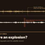 Was there an explosion at CFB Wainwright? We checked the seismographs
 CFB Wainwright Deaths: Alberta Says Its Medical Examiner’s Investigation is Separate from Military’s


[…] automatic weather station reports two different wind measurements, and confusing them explains most of the […]
[…] training area at 2:49 p.m., and likely as early as 12:17 p.m., before the roughly 4 p.m. time the Department of National Defence says a fire “ignited.” Four more satellite passes overnight, reviewed by Prime Rogue, […]