Category Canada

How we found the 82 km/h CFB Wainwright gust: a step-by-step guide to Environment Canada’s wind data

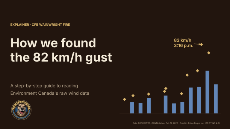
Header graphic reading "How we found the 82 km/h gust: a step-by-step guide to reading Environment Canada's raw wind data," beside a bar chart of hourly wind at the CFB Wainwright weather station with the 82 km/h gust at 3:16 p.m. marked in gold.

How we found the CFB Wainwright 82 km/h gust: a step-by-step guide to Environment Canada’s wind data Kevin J.S. Duska Jr. | Prime Rogue Inc | Calgary, AB | October 21, 2026 The strongest wind recorded near the CFB Wainwright…

CFB Wainwright Deaths: Alberta Says Its Medical Examiner’s Investigation is Separate from Military’s

Headline graphic reading “Whose investigation is it?” Beside it are two overlapping circles, one labelled Federal (National Defence Act) and one labelled Provincial (Fatality Inquiries Act), with CFB Wainwright in the overlap.

CFB Wainwright deaths: Alberta says its medical examiner’s investigation is separate from the military’s Kevin Duska | Prime Rogue Inc | Calgary, AB | Oct 21, 2026 Update, Oct. 21, 2026: This story has been updated with a provincial official’s…
Every Warning Was On The Record: The CFB Wainwright Deaths Were Highly Likely Preventable

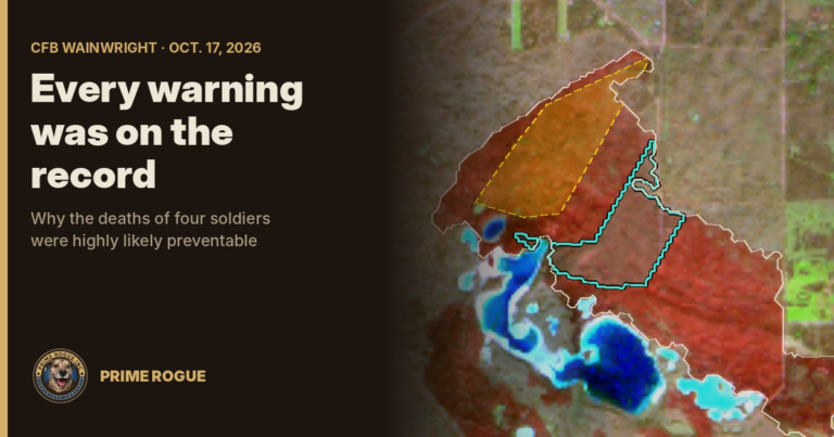
A satellite image of the burn scar at CFB Wainwright, with the fire before 3:16 p.m. outlined in yellow and the most likely area of the overrun outlined in teal, beside the title "Every warning was on the record."

Every Warning Was On The Record: The CFB Wainwright Deaths Were Highly Likely Preventable Kevin J.S. Duska Jr. | Prime Rogue Inc | Calgary, AB | October 21, 2026 The fire had burned for hours, the deadly wind was forecast…
CFB Wainwright Fire: The Flank Became The Front

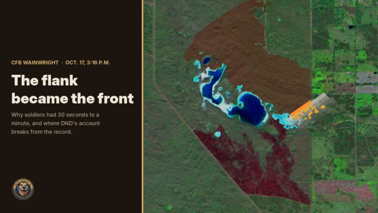
Title card reading "The flank became the front" beside a satellite map of CFB Wainwright, showing the burned area and an orange fire front advancing southeast with smoke ahead of it.

CFB Wainwright: The Flank Became the Front New satellite imagery shows a 2-km fire line turned into a wall of fire when a forecast cold front hit at CFB Wainwright. It explains how soldiers had 30 seconds to a minute,…
Gas wells played no part in the CFB Wainwright fire, records show

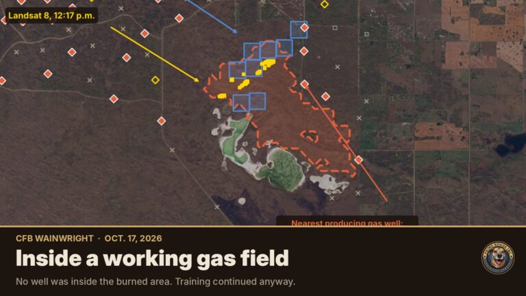
Satellite map of the CFB Wainwright fire area showing yellow fire detections and a red dashed burned area between two lakes, with red diamonds marking producing gas wells around it, under the headline "The fire and the gas wells."

Gas wells played no part in the CFB Wainwright fire, records show No well lies inside the area that burned on Oct. 17 at CFB Wainwright, and the provincial regulator says no operator has reported an incident. The well records…
A week of satellite data on the CFB Wainwright fire: burning by 2:49 p.m., likely since morning

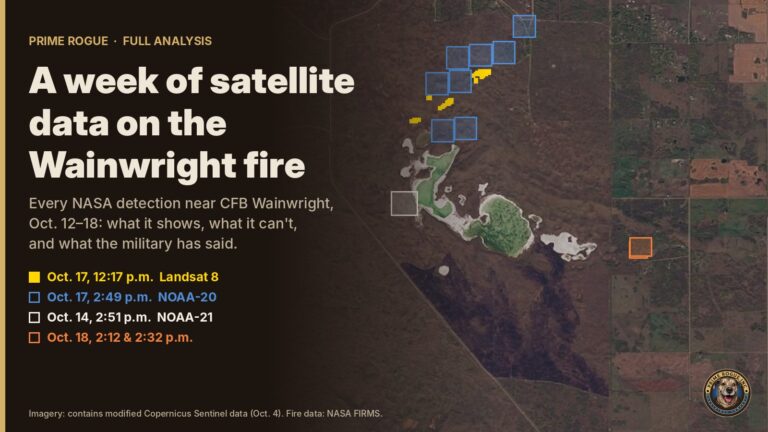
Prime Rogue full analysis header reading A week of satellite data on the Wainwright fire. Every NASA detection near CFB Wainwright, Oct. 12 to 18: what it shows, what it can't, and what the military has said. A Sentinel-2 satellite image of the training area shows a saline lake with NASA fire detections plotted on it: yellow Landsat 8 detections and blue NOAA-20 squares from Oct. 17 north of the lake, a white NOAA-21 square from Oct. 14 on the lake's west shore, and orange squares from Oct. 18 to the southeast. Every NASA fire detection near CFB Wainwright from Oct. 12 to 18, on a Sentinel-2 image of the training area taken Oct. 4. (Imagery: contains modified Copernicus Sentinel data. Fire data: NASA FIRMS. Graphic: Prime Rogue Inc.)

A week of satellite data on the Wainwright fire: burning by 2:49 p.m., likely since morning By Kevin J.S. Duska Jr., Prime Rogue Inc. | CalgaryPublished 00:00 MT, Monday, Oct. 19, 2026. This analysis brings together and updates Prime Rogue’s…
DND said the Wainwright fire “ignited” at 4 p.m. The military now says it was known for hours

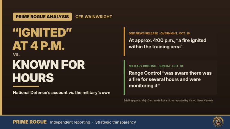
Analysis header reading “Ignited” at 4 p.m. vs. known for hours: National Defence’s account vs. the military’s own. Two quote cards compare DND’s overnight Oct. 18 news release, which says at approximately 4:00 p.m. “a fire ignited within the training area,” with the Sunday military briefing, where Range Control “was aware there was a fire for several hours and were monitoring it.”

DND said the Wainwright fire “ignited” at 4 p.m. The military now says it was known for hours Published 2050 MT, Sunday, Oct. 18, 2026. By Kevin J.S. Duska Jr. | Prime Rogue Inc | Calgary, AB This follows Prime…
Satellite record fits scenario that an exercise fire was burning before the CFB Wainwright incident

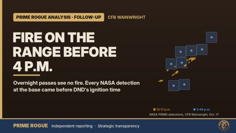
Prime Rogue Analysis follow-up header reading “Fire on the range before 4 p.m.,” with the subhead: overnight passes see no fire, and every NASA detection at the base came before DND’s ignition time. The actual NASA detection pattern from CFB Wainwright is plotted on the right.

Satellite record fits scenario that an exercise fire was burning before the CFB Wainwright incident By Kevin J.S. Duska Jr. | Prime Rogue Inc Published 0630 a.m. MT / 0700 a.m. ET, Sunday, Oct. 18, 2026. Satellite data current to…
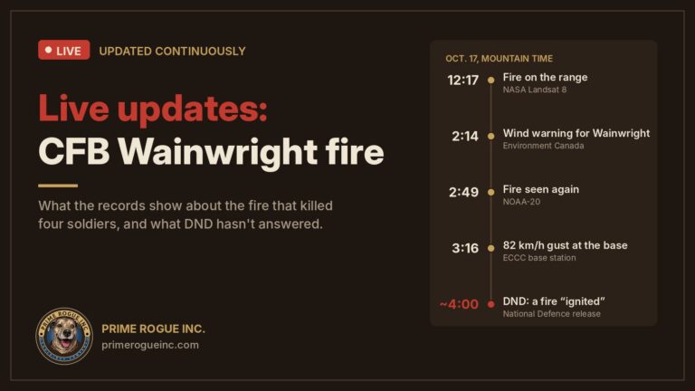
LIVE: CFB Wainwright Fire: What The Data and Records Show About the Blaze that Killed Four Soldiers

Prime Rogue header reading "Live updates: CFB Wainwright fire," with the subhead "What the records show about the fire that killed four soldiers, and what DND hasn't answered." Beside it is an Oct. 17 timeline: fire on the range at 12:17 p.m. (NASA Landsat 8), a wind warning for Wainwright at 2:14 p.m. (Environment Canada), fire seen again at 2:49 p.m. (NOAA-20), an 82 km/h gust at 3:16 p.m., and National Defence's statement that a fire "ignited" at about 4 p.m. The Prime Rogue Inc. logo is in the corner.

LIVE: CFB Wainwright Fire: What The Data and Records Show About the Blaze that Killed Four Soldiers By Kevin J.S. Duska Jr., Prime Rogue Inc. | Calgary Last updated: 6 p.m. MT / 8 p.m. ET, Tuesday, Oct. 20, 2026…

Verified by MonsterInsights