Address
304 North Cardinal St.
Dorchester Center, MA 02124
Work Hours
Monday to Friday: 7AM - 7PM
Weekend: 10AM - 5PM

Address
304 North Cardinal St.
Dorchester Center, MA 02124
Work Hours
Monday to Friday: 7AM - 7PM
Weekend: 10AM - 5PM
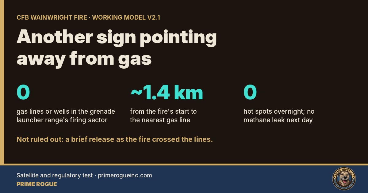
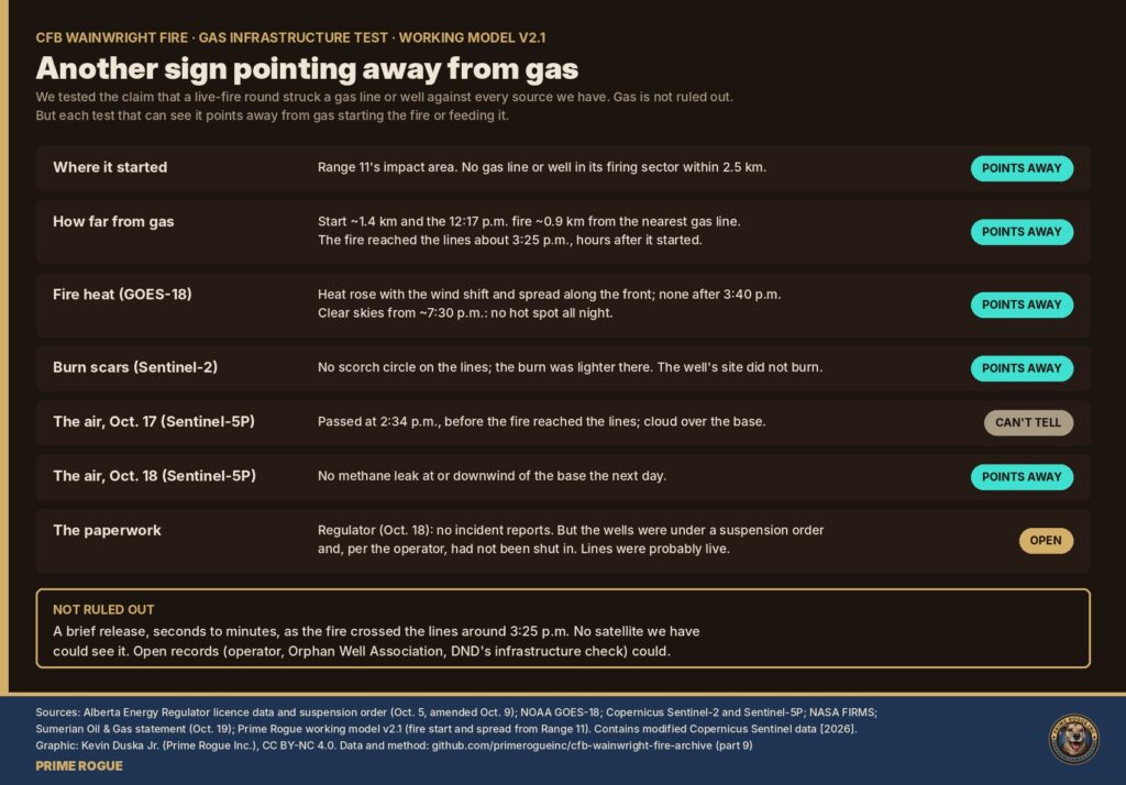
On the night of Oct. 17, Global News reported that military sources believed the live-fire exercise “was believed to have hit a gas line or gas well on the base, causing an explosion.” Maj.-Gen. Wade Rutland said his “initial impression is it’s not, but we will definitely check,” and described sending a team to inspect the oil and gas infrastructure. Versions of the claim spread widely on social media; the Canadian Press fact-checked several. The Alberta Energy Regulator (AER) said the next day it had received no incident reports about infrastructure on the base.
CFB Wainwright sits on an active gas field: hundreds of licensed wells and a dense web of small gathering lines. So the claim is not far-fetched on its face. It is testable.
Officials said at the Oct. 22 briefing that the fire started on the automatic grenade launcher range. The base’s standing orders, as reported by Global News, identify that as Range 11. Our working model finds the best-fitting start 1.9 to 2.5 km east of Range 11, at the end of the C16’s reach, burning from the morning.
We mapped every AER-licensed pipeline and well around the fire against Range 11’s likely firing sector, east into Permanent Danger Area 2. None lies inside it within 2.5 km, on any bearing from 20° to 160°. The nearest operating gas lines to Range 11 are 350 to 560 m west and southwest of it, behind or beside the firing point. The gas lines at Range 2 and the road head are 3.5 to 4 km away, beyond the grenade launcher’s range.
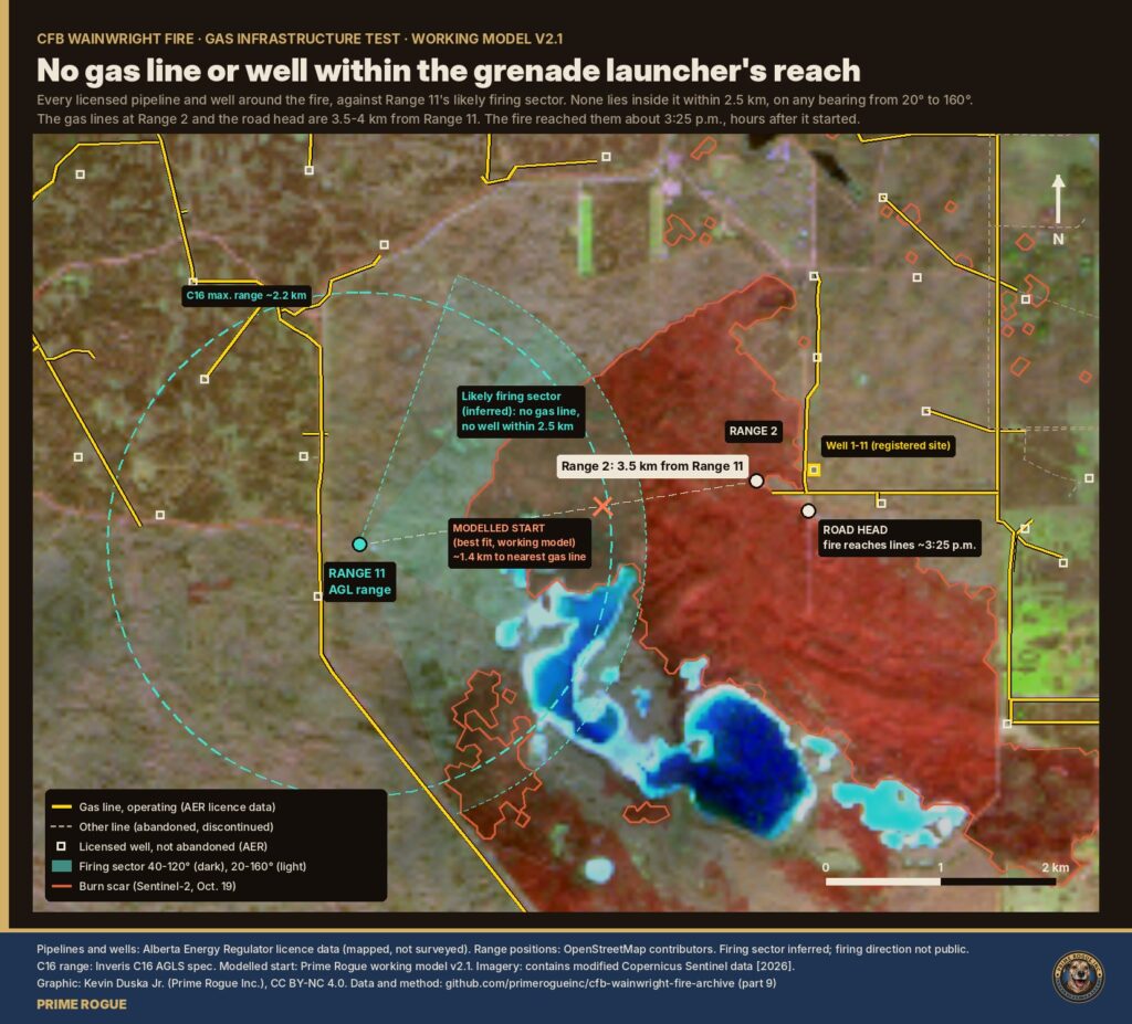
Caveat: the firing direction is not public. We infer the sector from the range’s position on the edge of the danger area, with another range 1.5 km to the west. Pipeline and well positions are mapped, not surveyed.
At 12:17 p.m., Landsat recorded the fire burning about 0.9 km from the nearest gas line. Our model has the front reaching the Range 2 and road-head lines at about 3:24 to 3:26 p.m., minutes after the wind turned. If gas played any part, it was as something the fire ran into, not what started it.
The GOES-18 weather satellite scans the base every 10 minutes. Cloud hid the fire for most of the afternoon. When it broke, the fire’s heat output was 76.5 MW at 3:10 p.m., then 1,215 MW at 3:30 p.m., spread across three 2 km pixels along the front, then 336 MW at 3:40, then nothing. From about 7:30 p.m. the sky was clear all night, with no hot spot.
A ruptured line feeding a jet fire would show as a fixed, persistent heat source until it was shut off. There was none after 3:40 p.m. A release lasting a few minutes around 3:25 p.m., though, could hide inside a single scan.
A gas fire at a break leaves a circle of scorched ground centred on the line. A wind-driven grass fire leaves a pattern set by the fuel and the front. We measured burn severity from Sentinel-2 images taken before and after the fire, along both operating lines and around the well.
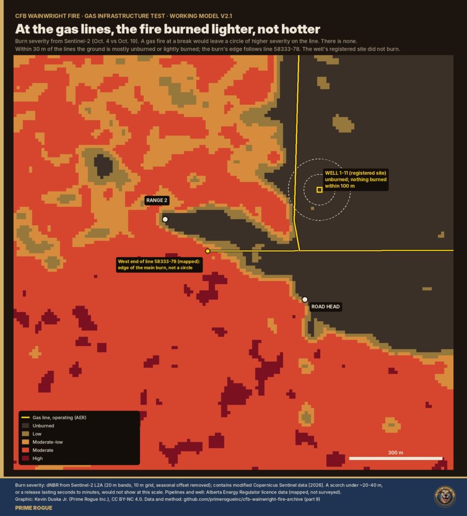
Caveat: Sentinel-2’s 20 m pixels cannot resolve a crater, or a scorch smaller than about 20 to 40 m. A release lasting seconds would leave no mark at this scale.
Sentinel-5P measures gases and haze over the whole region once a day. We pulled carbon monoxide, aerosol index and methane for Oct. 16 to 18. Its Oct. 17 pass came at 2:34 p.m., about 50 minutes before the fire reached the lines, and cloud blanked carbon monoxide and methane over the base. Smoke haze over the base was no higher than the day before (aerosol index 0.40 on Oct. 16, 0.38 on Oct. 17, 0.24 on Oct. 18).
On Oct. 18, methane coverage was good. There was no leak at or downwind of the base: 1,914 parts per billion within 10 km, against 1,927 across the region.
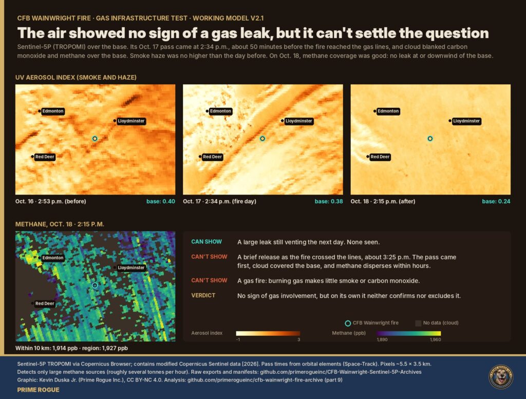
What this does and doesn’t show. The atmospheric data is not evidence of gas involvement. On its own, though, it can’t settle the question: burning gas makes little smoke or carbon monoxide, and a short release disperses within hours. What it does show is that no large leak was still venting the next day.
On Oct. 5, the AER suspended Sumerian Oil & Gas Inc., the licensee of the Range 2 lines, and authorized the Orphan Well Association to shut in and secure its wells, facilities and pipelines within 14 days. The amended order lists well 1-11-44-7W4, at Range 2, as active.
In an Oct. 19 statement, Sumerian said an Orphan Well Association contact told it on the evening of Oct. 17 that “none of the Sumerian wells on the range had been shut in,” and that the association had not planned to attend the base until Oct. 27. Sumerian says it had no operational control of the sites after Oct. 5, that its emergency line had been redirected to the association, and that no authority has told it any of its wells or pipelines was involved. National Observer and Bloomberg have also reported on the order.
So the gas lines the fire crossed were probably still under pressure, with no operator on site. That makes the physical evidence above the main test, and it’s why the records below matter.
A brief release, from seconds to a few minutes, as the fire crossed the lines around 3:25 p.m. It would fall inside one GOES scan, below Sentinel-2’s resolution and after the Sentinel-5P pass. Soldiers’ accounts of an explosion could have other causes too: munitions in the fire, or violent fire behaviour in an 82 km/h gust. We can’t tell these apart from orbit.
We are putting these questions to the AER, the Orphan Well Association, Sumerian and DND, and will update this article when they reply.
Earlier Prime Rogue work placed “the wellsite” at the mapped west end of line 58333-78, about 170 m from the Range 2 point. The AER’s registered location for well 1-11 is about 410 m east-northeast of that, about 360 m north of the road head and outside the burn. Both positions are mapped, not surveyed; both are shown in our graphics.
Everything here is reproducible. Scripts, outputs and a full write-up are in part 9 of our archive; raw Sentinel-5P exports are in their own repository. Sources: AER licensed-pipeline and well data, suspension order and announcement; NOAA GOES-18 ABI; Copernicus Sentinel-2 and Sentinel-5P; NASA FIRMS; Environment and Climate Change Canada station CZWN; Global News; the Canadian Press; Sumerian Oil & Gas. The fire’s start and spread come from our working model v2.1, a calibrated grass-fire model starting from Range 11’s impact area.
This is a working model, not a final finding. Further data will confirm or disconfirm it until, or unless, we build a new one. Follow updates on our CFB Wainwright Live Updates Page.
Nothing we’ve found supports that. Officials say the fire started on the grenade launcher range, and no gas line or well lies within that range’s reach. The fire burned for hours before reaching any gas line.
Yes. Small, pressurized natural gas gathering lines cross the Range 2 and road-head area. The fire reached them around 3:25 p.m.
We can’t rule out a brief release as the fire crossed the lines. We found no sign of a sustained gas fire or leak.
Probably not. The regulator ordered them shut in on Oct. 5; the operator says it was told on Oct. 17 that none had been.
 Gas wells played no part in the CFB Wainwright fire, records show
 Satellites saw fire on CFB Wainwright range hours before DND says it ignited
 What Happened to C Company: How a Forecast Wind Shift Trapped Soldiers at CFB Wainwright
 Satellite record fits scenario that an exercise fire was burning before the CFB Wainwright incident


[…] Oct. 17, 2026, was an 82 km/h gust from the west at 3:16 p.m. MDT, logged by the base’s own Environment Canada weather station. That number has been reported widely, but it does not appear in the hourly weather tables […]
[…] (OCME) is conducting its own investigation into the CFB Wainwright deaths, separate from the Canadian Armed Forces, a provincial official with knowledge of the matter told Prime […]
[…] the Canadian Armed Forces statement describing the fire as reported at approximately 16:00 and the Department of National Defence news release stating the fire ignited at approximately 4:00 p.m. I request all drafts and versions, […]
[…] of it was recorded by NOAA’s GOES-18 weather satellite, which photographs North America every 10 minutes, and all of it is public. Four soldiers died in […]
[…] reported, citing multiple Canadian Armed Forces sources, that a live-fire training exercise hit a gas line or gas well on the base, causing an explosion around 4 p.m. The base sits on an active gas field; […]