Address
304 North Cardinal St.
Dorchester Center, MA 02124
Work Hours
Monday to Friday: 7AM - 7PM
Weekend: 10AM - 5PM

Address
304 North Cardinal St.
Dorchester Center, MA 02124
Work Hours
Monday to Friday: 7AM - 7PM
Weekend: 10AM - 5PM
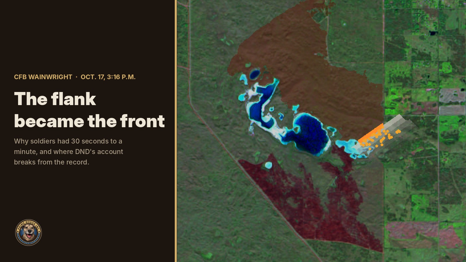
When the wind swung northwest over CFB Wainwright at 3:16 p.m. on Oct. 17, the fire on the range did not need to travel to become dangerous. Its long side became its front.
New Sentinel-2 satellite imagery from Oct. 19 shows what that meant on the ground. A single run of burned grass, about 2.1 km wide and up to 5.9 km long, stretches southeast from the line where a NASA satellite saw fire at 12:17 p.m. The scar is almost exactly as wide as that fire line was long.
That shape answers a question families and readers have been asking since Maj.-Gen. Wade Rutland relayed what his commander on the ground told him: “within 30 seconds to a minute they saw no fire, and then there was a fire right on top of them.” The soldiers’ account holds up. What does not hold up is the official account of the fire around them.
Sgt. Morgan Wong, Pte. Shaun Farrell, Pte. Aidan Goulding and Pte. Hayden Lykkemark died. Thirty-nine others were taken to hospital. Nothing in this article assigns blame to any person or alleges that anyone acted with intent. It sets public records beside public statements.
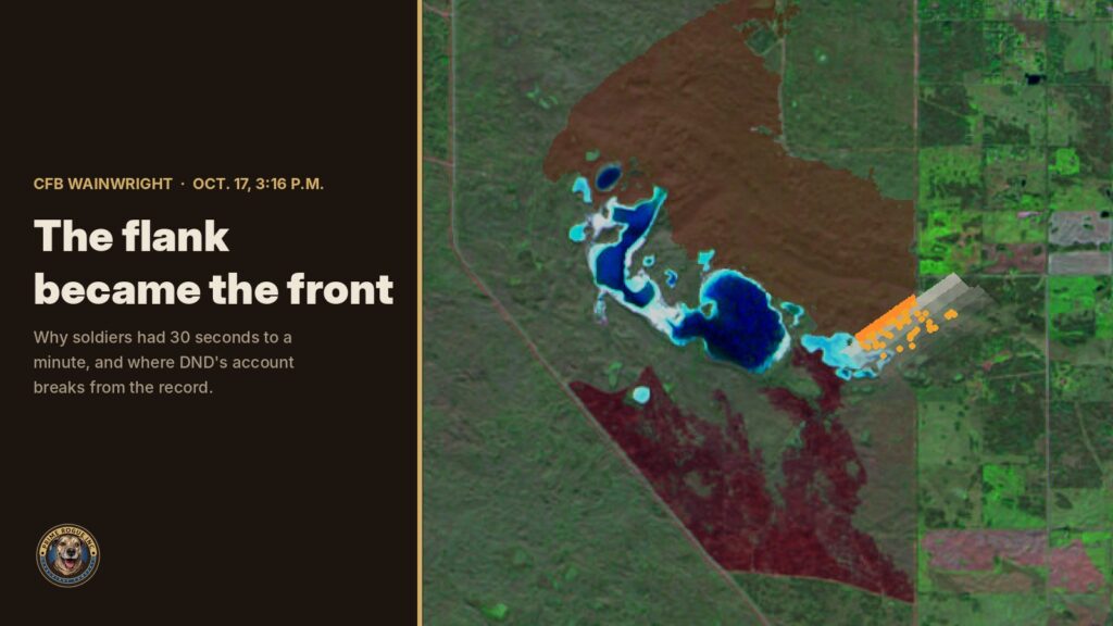
The new imagery comes from the European Space Agency’s Sentinel-2, which photographed the base at 10-metre resolution on Oct. 19. We compared it with a cloud-free Sentinel-2 image from Oct. 4 and mapped the change with a standard burn-severity index (dNBR).
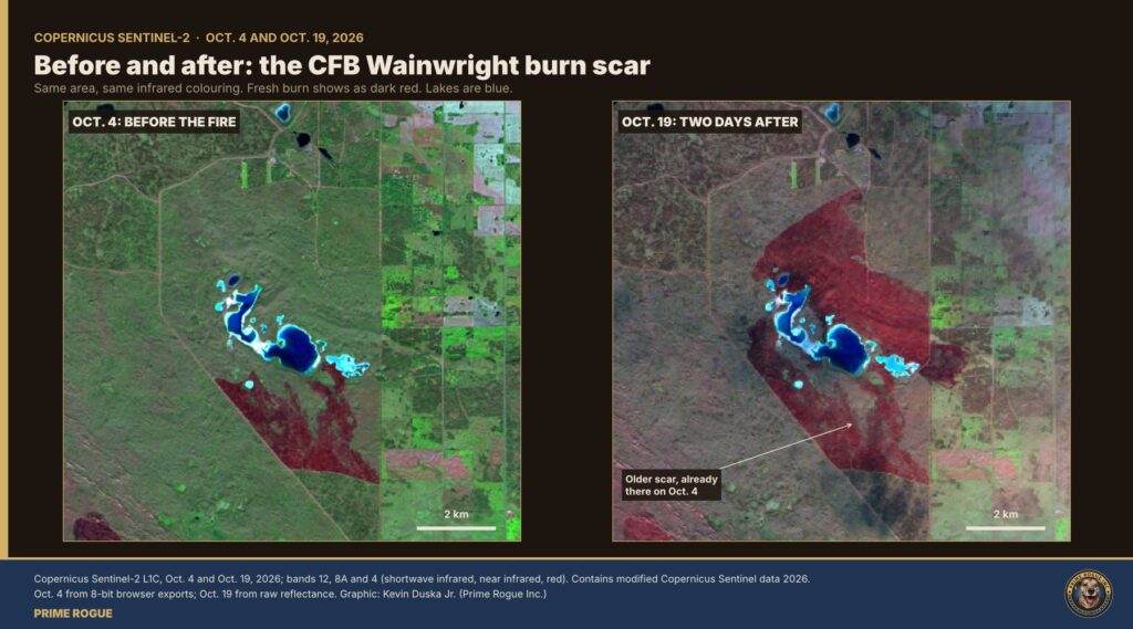
The new burn starts at the fire line Landsat 8 recorded at 12:17 p.m., between Jamieson Lake and Peterson Pond, and runs southeast. The lakes bound its southwest side. Its northeast side is a nearly straight edge.
Five measurements matter:
The burn was most severe 2 to 4 km along the run, where a wind-driven grass fire would be at full speed. Satellites detected heat at the southeast end of the scar again at 2:10 and 2:30 p.m. on Oct. 18, inside the lobe east of the road.
A separate burned patch of about 1 km² sits southwest of the main scar. It matches a NOAA-21 fire detection from Oct. 14 and is not part of this fire.
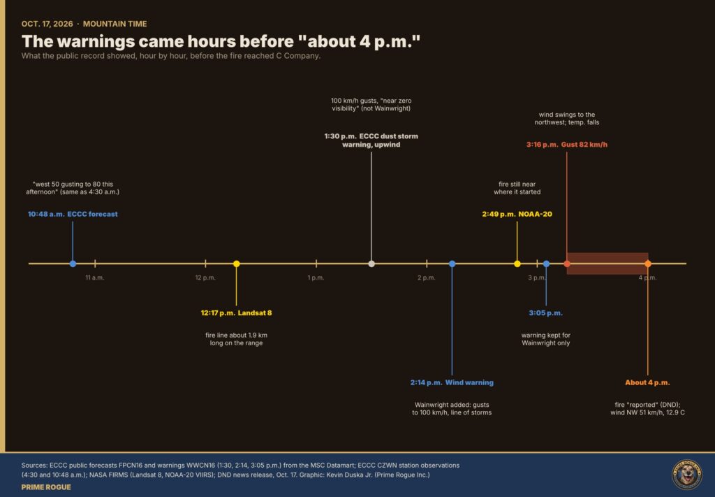
The Canadian Armed Forces memo reported by Global News called the wind change “unexpected and sudden.” Rutland spoke of “uncommonly strong winds” and called what happened “uncommon, rapid.” Environment and Climate Change Canada’s archived bulletins tell a different story.
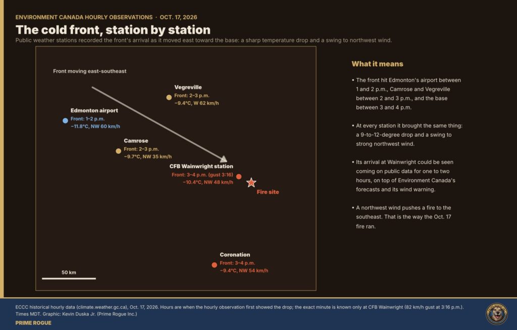
The front crossed Alberta station by station. Edmonton International recorded the shift between 1 and 2 p.m., Vegreville and Camrose between 2 and 3 p.m., and Wainwright between 3 and 4 p.m. NOAA’s GOES-18 weather satellite showed the storm line approaching for at least 20 minutes before the gust hit. CBC meteorologist Johanna Wagstaffe described it as a cold front that shifted winds “from southwesterly to northwesterly,” calling it “a significant change for fire behaviour.”
The fire danger was not low. Natural Resources Canada’s Canadian Wildland Fire Information System recorded a Fire Weather Index of 30.8 at the CFB Wainwright station that day, in the Extreme class. Humidity at the base was 16% to 17% at 2 and 3 p.m. Recomputing the index hour by hour from the station’s own observations, we get about 59 at 3 p.m. and about 91 at 4 p.m., after the front. Those hourly figures are our calculation, using the standard Canadian equations; the 30.8 is NRCan’s.
A grass fire pushed by a steady wind grows long and narrow. Its head runs downwind, and its two long sides, the flanks, burn slowly outward.
From noon until about 3:15 p.m., the wind at Wainwright blew from the southwest. A fire on the range under that wind would run northeast and develop a long flank facing southeast. The Landsat line at 12:17 p.m. ran northeast to southwest, at about 55°.
Then the wind turned roughly 70°, from southwest to northwest. The side that had been burning slowly sideways now faced straight downwind, along its entire length.
Australia’s national science agency, CSIRO, has studied this for decades. In their reference text Grassfires, Phil Cheney and Andrew Sullivan write: “An alteration in wind direction can change a flank fire to a head fire, which within 15 seconds can spread at its maximum speed.” A CSIRO review of the 1983 Ash Wednesday fires describes “a 90º wind direction change, turning extended lengths of eastern flank into headfires.” At Wangary, in South Australia, in 2005, a wind change “turned the approximately 55 km long eastern flank of the fire into a headfire.” Nine people died.
The Wainwright burn scar has that shape: a front as wide as the old flank, running downwind of the new wind.
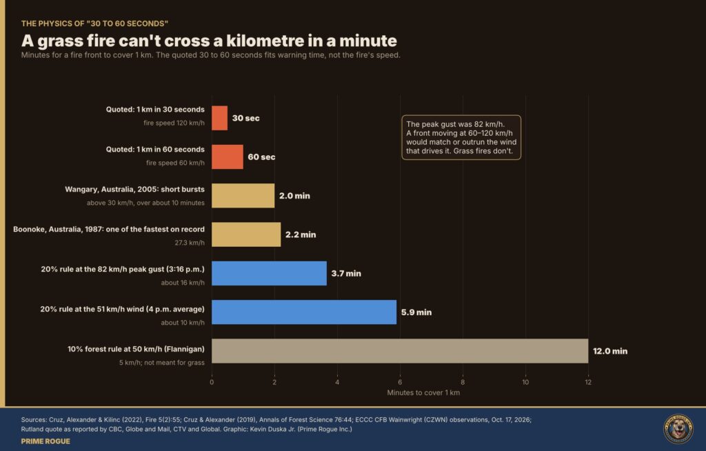
Rutland told reporters the fire was “a kilometre away” when the wind shifted. In the Globe and Mail, CTV, Global and CBC versions of his remarks, the fire covered that distance in “30 to 60 seconds.” The Associated Press reported it as “36 seconds,” which appears to be a mishearing of “30, 60.” Prime Minister Mark Carney told the House of Commons the fire “jumped nearly a kilometre in less than a minute.”
As a description of the fire’s speed, that cannot be right. A kilometre in 30 seconds is 120 km/h. A kilometre in 60 seconds is 60 km/h. The strongest gust recorded at the base all afternoon was 82 km/h.
Peer-reviewed research on grass fires finds they spread at roughly 20% of the open wind speed in strong winds (Cruz, Alexander and Kilinc, 2022). At Wainwright’s 51 km/h post-front wind, that is about 10 km/h, or about six minutes per kilometre. At the 82 km/h gust, about 16 km/h, or under four minutes. Some of the fastest grass fires ever measured, at Boonoke in 1987 and in short bursts at Wangary in 2005, reached 27 to 30-plus km/h. Even at those speeds, a fire needs about two minutes to cover a kilometre.
The soldiers’ words point somewhere else. “They saw no fire, and then there was a fire right on top of them” describes how much warning they had, not how fast the fire moved. Four well-documented effects can shrink a fire that is minutes away into seconds of warning. All four were present on Oct. 17.
When a flank becomes the head, there is no single tongue of flame to watch approaching. A 2-km line advances together. There is no end to see coming and no way around it.
Before the change, the southwest wind carried smoke northeast, away from anything southeast of the fire. After the change, the northwest wind pushed smoke and dust southeast, ahead of the front and toward anyone downwind. Upwind on the same storm line, ECCC was already warning of “near zero visibility” in blowing dust. In Wainwright, resident Tanya Porter saw “a wall of smoke” and asked: “Is that a fire or dust?” A front moving behind its own smoke can be close before anyone sees flame.
In strong wind, burning grass and debris are thrown ahead of the front and light spot fires. Researchers warn that spot fires can be mistaken for the main front. For people downwind, fire can appear around them before the main front arrives.
In controlled studies, people who watch a stressful event consistently overestimate how long it lasted, and more stress produces bigger overestimates (Loftus et al., 1987). “Thirty seconds to a minute” is a human account of warning time, not a stopwatch reading. If anything, the warning may have been shorter.
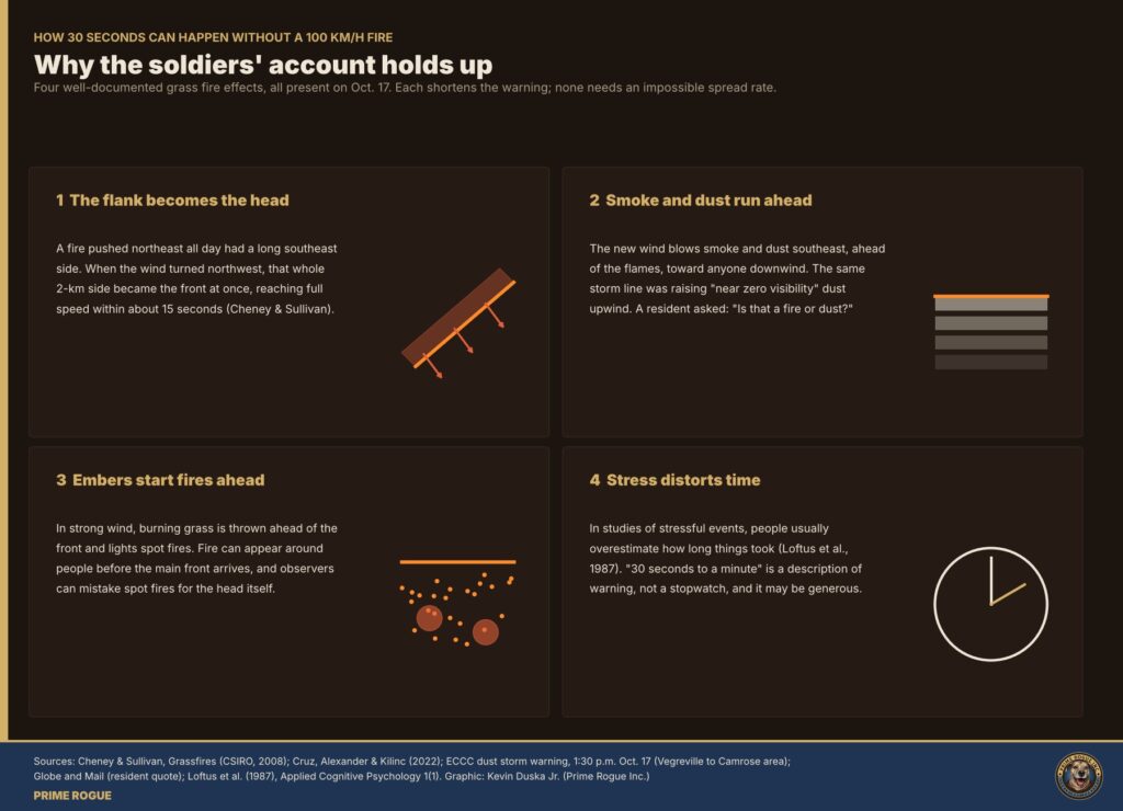
Put together, a front moving at 10 to 16 km/h, hidden by smoke and dust, throwing embers ahead and arriving along its full width, can leave seconds of warning without breaking any law of physics. That is also why the decisions that mattered most had to come before 3:16 p.m. Once the front arrived, there was no time left to make them.
CSIRO researchers have a name for this: the “dead-man zone.” Their 2001 paper warns that “if the wind direction changes, the fire can advance so rapidly that the firefighters have very little time to seek refuge in the burnt area.” Protection from a flank under a forecast wind change comes from distance and from decisions made in advance.
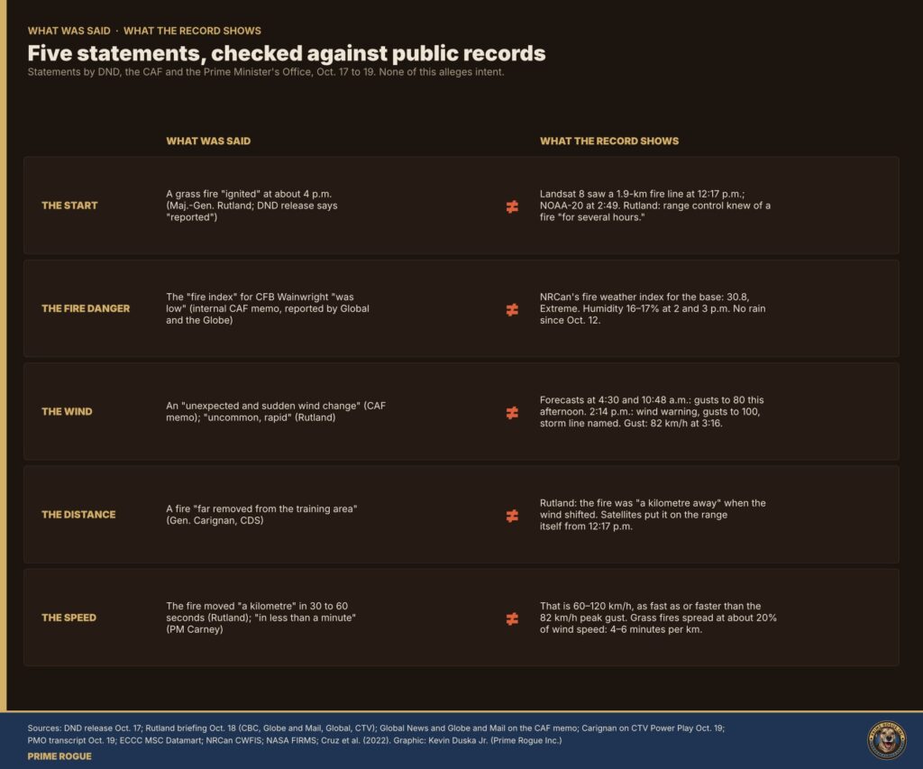
Said: DND’s news release put the incident at “approximately 1600 hrs (MDT),” and the CAF’s first statement said a fire was “reported” then. At an Oct. 18 news conference, Rutland said “a grass fire ignited in the training area” at about 4 p.m.
Record: Landsat 8 recorded a fire line about 1.9 km long at 12:17 p.m. NOAA-20 recorded it at 2:49 p.m. GOES-18 recorded heat at the site from about 3:10 p.m., intensifying through 3:40 p.m. Rutland himself said range control “knew there was a fire for several hours.” The Globe and Mail reported that DND said the fire ignited “at about noon.” Global News also reported Rutland saying the fire “did not start within the training area,” which conflicts with his own “ignited in the training area.”
Our reading: “About 4 p.m.” is best read as when the fire was reported or reached the soldiers, not when it started. DND has not said which.
Said: An internal CAF memo, reported by Global News and the Globe and Mail, said the “fire index” for CFB Wainwright “was low.” No official has said this on the record.
Record: NRCan’s Fire Weather Index for the base station was 30.8, Extreme. The Globe reported that NRCan’s system showed fire danger “very high or extreme” near Wainwright that afternoon. Humidity was 16% to 17%. No rain had fallen since Oct. 12.
Our reading: We don’t know which index the memo meant. DND has not said.
Said: The memo described an “unexpected and sudden wind change.” Rutland said: “This was uncommon, rapid, and I certainly hadn’t seen anything like it.” He added that the weather for most of the day was “well below 50 kilometres.”
Record: Two ECCC forecasts that morning called for gusts to 80 km/h in the afternoon. A wind warning naming Wainwright went out at 2:14 p.m., an hour before the gust. Rutland is right that the wind before the front was moderate: the station’s strongest gust before the front was about 51 km/h, at 2:48 p.m.. The change was sudden. It was not unexpected.
Said: Chief of the Defence Staff Gen. Jennie Carignan told CTV: “We understand there was a fire that was far removed from the training area, and the fire basically behaved in an unexpected fashion.”
Record: Rutland said the fire was “a kilometre away” when the wind shifted. The satellites place the fire on the range itself from 12:17 p.m., and the burn scar starts there. A kilometre downwind of a 2-km fire line, with a wind change forecast, is not far removed.
Said: “That is not normal for a fire to move a kilometre” in 30 to 60 seconds (Rutland). The fire “jumped nearly a kilometre in less than a minute” (Carney).
Record: That would take a fire speed of 60 to 120 km/h. The published research and the station’s wind data put the likely speed at 10 to 16 km/h, or four to six minutes per kilometre.
Our reading: The soldiers’ 30 to 60 seconds is credible as warning time. Turned into a spread rate, it suggests the fire was too fast for anyone to have anticipated. The record shows the danger was foreseeable for hours. Only the final approach was fast.
The Canadian Forces National Investigation Service is investigating with RCMP support. Carignan has also announced a board of inquiry, which she intends to make public, a technical investigation and an Alberta coroner’s investigation. Rutland declined to tell the Globe and Mail what rules govern training in high winds, and DND could not immediately point to the relevant section of its manual.
Before publishing our Oct. 19 findings, Prime Rogue sent them to National Defence and asked:
National Defence had not responded by publication. We will add any response.
Correction policy: if you see an error, write to kevin at primerogueinc.com or press at primerogueinc.com
Every concrete claim in the article, the evidence behind it, and how confident we are. “Primary” means we hold the original record.
| Claim | Evidence | Confidence |
|---|---|---|
| Fire line about 1.9 km long at 12:17 p.m., oriented about 55° | 59 Landsat 8 detections, NASA FIRMS; principal-axis fit | High (primary) |
| NOAA-20 fire at 2:49 p.m. near the start area | NASA FIRMS VIIRS | High (primary) |
| GOES-18 heat from about 3:10 p.m., intensifying to 3:40 | GOES-18 L1b band 7 anomaly | Medium: thin cloud over the site until about 2:40 p.m. limits earlier frames |
| About 11 km² burned in one run | Sentinel-2 dNBR above 0.2, water masked | High: 11.1 km² at 0.2 and 10.1 km² at a stricter 0.27; a looser 0.15 threshold also picks up older scars and noise |
| Burn axis 131°, width 2.1 km, reach 5.9 km | PCA of the burn mask | High |
| About 85% of burn outside 2:49 p.m. VIIRS pixels | Mask against VIIRS pixel footprints | High |
| About 1.1 km² burned east of the road at -110.8749 | Mask | High; the road as the training area’s edge comes from imagery and the MD’s “crossed the base fence” |
| Oct. 18 hot spots at the southeast end, 2:10 and 2:30 p.m. | NASA FIRMS VIIRS | High (primary) |
| Southwest patch is an Oct. 14 fire | NOAA-21 detection at 2:51 p.m. Oct. 14; patch already present before Oct. 17 is unconfirmed | Medium |
| Forecasts at 4:30 and 10:48 a.m.: “west 50 gusting to 80 this afternoon” | FPCN16 CWWG bulletins, MSC Datamart | High (primary) |
| 1:30 p.m. dust storm warning upwind, “near zero visibility”; did not cover Wainwright | WWCN16 CWWG 171930 | High (primary) |
| 2:14 p.m. wind warning added Wainwright; 3:05 p.m. kept for Wainwright only | WWCN16 CWWG 172014 and 172105 | High (primary) |
| 82 km/h gust at 3:16 p.m.; NW 51 km/h at 4 p.m.; 23.3 to 12.9 C | CZWN SWOB observations | High (primary) |
| Pre-front gust about 51 km/h at 2:48 p.m. | CZWN SWOB | High (primary) |
| Front reached Edmonton 1–2 p.m., Vegreville and Camrose 2–3 p.m., Wainwright 3–4 p.m. | ECCC hourly data | High (primary) |
| FWI 30.8, Extreme | NRCan CWFIS station data | High (primary) |
| Hourly FWI about 59 at 3 p.m. and 91 at 4 p.m. | Our calculation (Van Wagner hourly FFMC); labelled as ours | Medium |
| Grass fires spread at about 20% of wind speed | Cruz, Alexander & Kilinc 2022 | High (peer-reviewed) |
| Flank becomes head “within 15 seconds” | Cheney & Sullivan, Grassfires (CSIRO), quoted via secondary copy | Medium: check the printed edition |
| Wangary 2005: 55-km flank became head; nine deaths | CSIRO/Bushfire CRC simulation report; SA CFS | High |
| Stress leads people to overestimate duration | Loftus et al. 1987 | High (peer-reviewed) |
| Rutland: “30 seconds to a minute” quote, “several hours,” “a kilometre away” | CBC live blog, Globe and Mail; secondhand from an unnamed commander | High that he said it |
| AP’s “36 seconds” is likely a mishearing | Four outlets have “30 to 60” | Medium |
| CAF memo said fire index “was low” | Global News, Globe and Mail; internal document, not seen by us | Medium |
| Globe: DND said ignition “at about noon” | Single outlet | Low to medium; attributed |
| Rutland: fire “did not start within the training area” | Global timeline only | Medium; attributed |
| Carignan “far removed” quote | CTV/CP24 | High |
| Carney “nearly a kilometre in less than a minute” | PMO transcript | High (primary) |
| Smoke and dust shortened warning | Inference from the wind shift, the ECCC dust warning upwind and the resident quote | Inference; stated as the most likely explanation |
These are the link placements for the article body. News and government sources are follow. Social, mirror and commercial sources are nofollow.
Official statements
News reports
Data
Research
Prime Rogue, earlier coverage
 Satellite record fits scenario that an exercise fire was burning before the CFB Wainwright incident
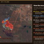 The storm line, then the fire: every satellite record of the CFB Wainwright fire, on one map
 Satellites saw fire on CFB Wainwright range hours before DND says it ignited
 DND said the Wainwright fire “ignited” at 4 p.m. The military now says it was known for hours


[…] reports and posts online suggested a gas well or gas line was involved in the fire that killed four Canadian soldiers at CFB Wainwright on Oct. 17. The public records say […]
[…] when the earlier fire started, whether it was being managed, and what happened at 4 p.m. that DND describes as the moment a fire […]
[…] started the fire. Nothing in the record confirms or rules out live-fire training, an ammunition burn, an explosion or […]