Address
304 North Cardinal St.
Dorchester Center, MA 02124
Work Hours
Monday to Friday: 7AM - 7PM
Weekend: 10AM - 5PM

Address
304 North Cardinal St.
Dorchester Center, MA 02124
Work Hours
Monday to Friday: 7AM - 7PM
Weekend: 10AM - 5PM
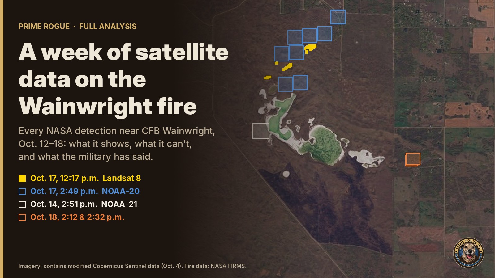
A week of satellite data on the Wainwright fire: burning by 2:49 p.m., likely since morningFour Canadian Armed Forces members were killed and 39 people received hospital care after a grass fire overran soldiers training at Canadian Forces Base Wainwright, Alberta, at about 4 p.m. on Saturday, Oct. 17. A National Defence news release said a fire “ignited” at about that time. At a briefing on Sunday, the military said range control had known of a fire for several hours.
Prime Rogue has now reviewed every NASA fire-detection file covering the area for the week of Oct. 12 to 18: seven downloads, 102 files, covering all seven satellites in NASA’s system. This is what that record shows, what it cannot show, and how it fits with what the military has said.
This is a structured analytic assessment, not a report of established fact. It uses standard estimative language:
Confidence (high, moderate or low) describes the quality of the evidence, not the probability. Each judgment can be tested against records National Defence holds; we list them below.
A fire was almost certainly burning on the CFB Wainwright range by 2:49 p.m. on Oct. 17, more than an hour before the wind turned. It was very likely burning by 12:17 p.m. It likely started that morning: the same ground showed no fire on the satellite passes of the previous five days or the night before.
The satellite record suggests a long, narrow, low-intensity fire burning with the southwest wind toward the northeast. When the wind swung to the northwest at about 4 p.m., that fire’s long southeast side would have become its front. It is likely, but not established, that this is the fire that reached C Company.
The week of data also suggests that fire on this part of the range was not unusual. NASA detected heat on the same lakeshore three days earlier, and an older burn scar lies just to the south. The satellite record cannot show what happened between 2:49 and 4 p.m., or what caused the fire.
Because of the time-sensitive nature of getting accurate FIRMS data, our earlier analyses used NASA’s 24-hour files, downloaded overnight Oct. 17–18. The later downloads add three detections near the base: one on Oct. 14, found only in the seven-day files, and two on the afternoon of Oct. 18, after our earlier downloads. Every Oct. 17 detection we reported earlier appears unchanged in all seven downloads.
NASA publishes its fire data in two formats, and they rate the 59 Landsat detections from 12:17 p.m. differently: all “low” confidence in one, and 34 “medium” and 25 “low” in the other. We previously described them only as low-confidence.
The seven-day files show no fire at the site from Oct. 12 until the morning of Oct. 17.
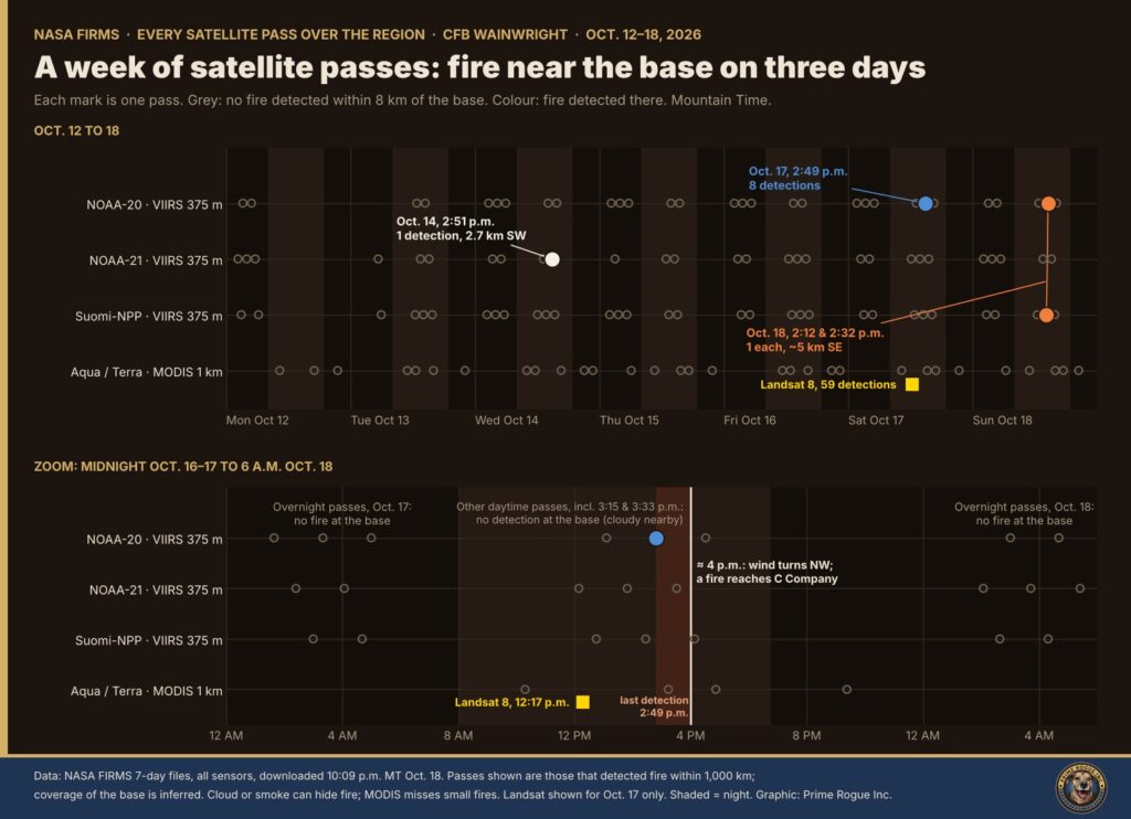
Our earlier reporting said VIIRS coverage of the base ended at about 3:30 p.m., but our 2 a.m. pass table and our pass graphic did not list the last two afternoon passes: Aqua MODIS at about 3:15 p.m. and NOAA-21 VIIRS at about 3:33 p.m. Neither recorded fire at the base. The NOAA-21 pass likely covered the base, which makes it the only VIIRS observation between the last detection and the deaths. Its significance is discussed below.
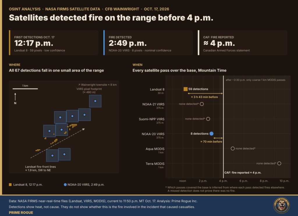
NOAA-20’s VIIRS sensor recorded eight detections at 2:49 p.m., all rated nominal confidence, with fire radiative power of 5.8 to 11.5 megawatts per pixel. Maj.-Gen. Wade Rutland said at Sunday’s briefing that range control “was aware there was a fire for several hours and were monitoring it.” A Wainwright resident saw “a wall of smoke” at about 3:30 p.m., The Globe and Mail reported. The detections lie about 8 km south-southwest of the town.
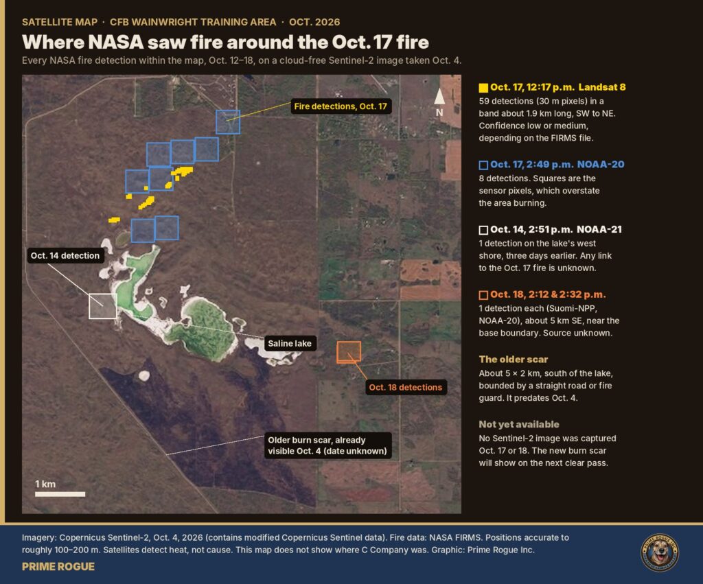
Landsat 8 recorded 59 detections at the same spot at 12:17 p.m. Thirty-four are rated medium confidence in one of NASA’s two formats. They form a coherent line rather than scattered pixels, and a second satellite saw fire in the same place two and a half hours later. Confidence stops short of high because Landsat’s fire product can confuse some hot surfaces with fire, and no other satellite saw the fire before 2:49 p.m.
NASA recorded no fire at this spot on any pass from Oct. 12 to 16. Four VIIRS passes between about 3 and 4:45 a.m. on Oct. 17 detected fires elsewhere in Alberta but none at the base. At night, VIIRS is sensitive to small and smouldering fires. A Sentinel-2 image from Oct. 16 shows the ground where the Oct. 17 detections fall had not burned. That leaves a likely start between about 4:45 a.m. and 12:17 p.m. A fire too small or too cool to detect overnight cannot be ruled out. A Terra MODIS pass at about 10:18 a.m. also recorded nothing, but MODIS, at 1 km resolution, often misses small fires.
At 12:17 p.m., the Landsat detections formed a band about 1.9 km long, aligned southwest to northeast. At 2:49 p.m., the VIIRS detections covered an area about 2.8 by 1 km, centred about 0.3 km further northeast. The base weather station recorded winds from the south-southwest to southwest all afternoon. A grass fire pushed by a steady wind typically stretches out in the direction it is driven. There are only two snapshots, and VIIRS pixels overstate the area burning.
The VIIRS readings show a low-intensity fire. A low-intensity fire moving northeast, away from or across the line of sight of anyone to its south or southeast, is the kind a range control might judge no threat. CNN reported range control considered the fire “contained” and not expected to move “anywhere near” the soldiers. That may explain the decision to continue training. It does not justify it.
When the wind direction changes, the long side of a fire that had been burning slowly can suddenly become its leading edge, a well-documented hazard in wildland firefighting. Environment Canada’s station at the base recorded the wind swinging to the northwest at about 4 p.m., gusting to 69 km/h, with the temperature falling about 10 degrees. If C Company was about a kilometre southeast of this fire, it lay directly in the new front’s path. Prime Rogue does not know where C Company was.
The training area is rolling upland with sand dunes, aspen groves and grassland. Regional elevation data shows no major ridge that would hide a smoke column, but low grass-fire flames behind a dune, a fold in the ground or a tree line could easily be out of sight. That fits the account Rutland relayed from the commander on the ground: “they saw no fire, and then there was a fire right on top of them.”
Rutland said the fire covered about a kilometre in 30 to 60 seconds, 60 to 120 km/h. Australia’s CSIRO, a leading grassfire research body, says grassfires under high fire danger can “at times” exceed 10 to 15 km/h. Possible explanations include the fire’s edge being closer than a kilometre when the wind shifted, embers starting new fires ahead of the front, or dense smoke arriving before the flames. Prime Rogue is not disputing the account of soldiers who survived. The Board of Inquiry should establish the distances.
NOAA-21 detected heat on the west shore of the same saline lake at 2:51 p.m. on Oct. 14, about 2.7 to 3 km south-southwest of the Oct. 17 detections. It was seen on one pass only: passes within about 45 minutes before and after recorded nothing, as did the following night’s passes. An older burn scar of about 5 by 2 km lies south of the lake, bounded by a straight road or fire guard, and was already visible on Oct. 4. In April 2024, the military carried out a prescribed burn in the Wainwright training area, which it said is routine to keep the area safe, Global News reported. Prime Rogue does not know what caused the Oct. 14 heat or the older scar, or whether either is connected to Oct. 17.
Several daytime passes recorded nothing at the base, including Suomi-NPP at about 2:29 p.m., just 20 minutes before NOAA-20 recorded eight detections. The nearest available station, at Lloydminster, recorded mostly cloudy skies through Saturday daytime. A pass that sees nothing that afternoon does not show the fire was out.
NASA’s NOAA-21 satellite passed over at about 3:33 p.m., roughly 27 minutes before the wind shift, and recorded no fire at the base. Based on where that pass detected fires elsewhere, about 250 km and more to the west, the base was likely inside its view, though off to the side, where the sensor’s pixels are larger and small fires are harder to detect.
This is the only satellite observation between the last detection and the deaths. Taken alone, it would fit a fire that had died down, or a separate fire that started later. But the same afternoon, under cloudy skies, a Suomi-NPP pass recorded nothing 20 minutes before NOAA-20 recorded eight detections. Prime Rogue assesses that the 3:33 p.m. pass does not meaningfully change the balance between the explanations below. It belongs in the record, and our earlier pass table should have listed it.
Suomi-NPP and NOAA-20 each recorded one low-intensity detection, 2.7 and 3.9 megawatts, at 2:12 and 2:32 p.m. on Sunday, Oct. 18. Both fall in the same spot, about 5 km southeast of the Oct. 17 detections, apparently just east of the road that forms the base boundary. A NOAA-21 pass at about 1:34 p.m. recorded nothing there, as did one at about 3:16 p.m.
Southeast is the direction a northwest wind would have pushed the Oct. 17 fire, and the fire crossed the base’s fire guards on Saturday, the military said. But these detections came 22 hours later, after the Municipal District of Wainwright said the fire was being held and after four overnight passes recorded no fire within 40 km. A flare-up, a mop-up burn or an unrelated farm burn would all fit. Prime Rogue makes no judgment on their source.
| Information | Available to range control? | Observable by troops on the ground? | Basis |
|---|---|---|---|
| A fire on the range | Yes, for “several hours” | Smoke very likely; flames likely not | Rutland; NASA FIRMS; terrain |
| Which way the fire was moving | Likely, if monitored | Possibly, from the drift of the smoke | FIRMS geometry; base station winds |
| Fire intensity | Likely | Unclear | VIIRS fire radiative power |
| Wind warning, gusts to 90 km/h | Publicly issued; whether it was received is unknown | Unknown | Environment Canada warning continued at 3:03 p.m. |
| A change in wind direction | Unknown whether forecast | Not until it arrived | Base station: SW to NW, temperature down about 10°C at 4 p.m. |
| Fire danger rating | Yes; a CAF memo says the fire index was low | Unknown | Global News, citing the memo |
| Recent fire in the same area | Likely, if range records are kept | Possibly | Oct. 14 detection; older burn scar |
The gap that matters most is the wind change. A 10-degree temperature drop and a swing from southwest to northwest is the signature of a cold front. Environment Canada forecasts issued Saturday called for gusts to 80 km/h, and a wind warning with gusts to 90 km/h was continued at 3:03 p.m. Whether the forecasts available to range control predicted a change in wind direction, not just strong winds, would go a long way to answering whether the deaths were foreseeable. Prime Rogue has not been able to confirm the wording of those forecasts.
| Hypothesis | Consistent with | Inconsistent with or unexplained | Assessment |
|---|---|---|---|
| A. One fire: the fire NASA detected was the fire range control monitored, and the wind shift drove its southeast side onto C Company | Rutland’s account of one fire about 1 km away, monitored for hours; FIRMS timing, location and shape; the base station wind shift | DND’s written statements that a fire “ignited” at about 4 p.m.; no detection on the 3:33 p.m. pass (weak, given cloud) | Most consistent with available evidence. Likely |
| B. Two fires: training started a new fire near C Company at about 4 p.m., separate from the monitored fire | The release naming the soldiers: “while conducting training a fire ignited”; no detection on the 3:33 p.m. pass (weak) | No account of the briefing describes a second fire; Rutland put the fire about 1 km from the troops before the wind shift | Roughly even chance or less; less consistent with the briefing |
| C. The monitored fire was elsewhere on the base, and the fire NASA detected is unrelated to the deaths | Nothing specific | Only one fire was detected on or near the base on Oct. 17, on any sensor | Unlikely |
Global News reported, citing multiple military sources, that a preliminary investigation suggests a munition from a live training exercise “sparked a fast-moving grass fire, causing Saturday’s explosion.” That would be consistent with either A or B. It does not say when the fire started. Rutland said C Company was training with “a multitude of ordnance,” and that the cause could be “any of that, or none of it,” CNN reported.
Prime Rogue has asked National Defence whether the fire range control was monitoring is the fire that reached C Company, and has made formal requests for these records under the Access to Information Act.
Satellites detect heat, not cause, and capture only the moment they pass overhead. Whether each pass covered the base is inferred from where it detected fires elsewhere; cloud, smoke and viewing angle can hide fire. No satellite recorded fire at the base between 2:49 p.m. and the deaths at about 4 p.m. A NOAA-21 pass at 3:33 p.m. recorded none; an Aqua MODIS pass at about 3:15 p.m. also recorded none, but it is unknown whether it covered the base. VIIRS pixels are 375 m or more across and overstate the area burning. Landsat’s fire product can mistake some hot surfaces for fire. The terrain assessment relies on regional data that cannot show individual dunes or tree lines. Nothing here identifies who decided training would continue or what they were told.
Fire detections are from NASA’s Fire Information for Resource Management System (FIRMS): Landsat 8 and 9, VIIRS on Suomi-NPP, NOAA-20 and NOAA-21, and MODIS on Aqua and Terra. Prime Rogue made seven downloads between 11:50 p.m. Oct. 17 and 10:15 p.m. Oct. 18 MT: the 24-hour files overnight, and the 48-hour, 72-hour and seven-day files for Canada and Alberta on the evening of Oct. 18. The files, a spreadsheet of all 70 detections within 40 km of the base and checksums for every file are available for download. Detections were de-duplicated by time, sensor and coordinates.
Whether a pass covered the base was inferred from the location and pixel size of its detections elsewhere. Distances and orientation were calculated from detection coordinates. The fire’s orientation used principal-component analysis. Imagery is from the European Space Agency’s Copernicus Sentinel-2 satellites, positioned using the image’s published coordinates and accurate to roughly 100 to 200 m. Weather is from Environment and Climate Change Canada’s CFB Wainwright station and the Lloydminster station.
Prime Rogue’s earlier reporting said that after about 3:30 p.m. on Oct. 17, only MODIS sensors passed over the base. Our 2 a.m. pass table and our “16 hours of satellite passes” graphic did not list the two passes at the end of that coverage: Aqua MODIS at about 3:15 p.m. and NOAA-21 VIIRS at about 3:33 p.m. Both were in the data we downloaded at the time, and neither recorded fire at the base. [CONFIRM WORDING ONCE NOTES ARE ADDED TO THOSE PIECES.]
Ongoing coverage: CFB Wainwright fire: live updates.
Sgt. Morgan Wong, Pte. Shaun Farrell, Pte. Aidan Goulding and Pte. Hayden Lykkemark were killed. Thirty-nine people received hospital care, 19 in critical condition. Prime Rogue extends its condolences to their families and to everyone injured.
CAF Family Information Line (24/7): 1-800-866-4546. Canadian Forces Member Assistance Program: 1-800-268-7708.
 Satellite record fits scenario that an exercise fire was burning before the CFB Wainwright incident
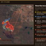 The storm line, then the fire: every satellite record of the CFB Wainwright fire, on one map
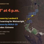 Every Warning Light Was On: What Most Likely Happened at CFB Wainwright
 DND said the Wainwright fire “ignited” at 4 p.m. The military now says it was known for hours


[…] scenario now being raised on national television, that a fire from Saturday’s training exercise at CFB Wainwright set off a gas well, fits the NASA satellite record Prime Rogue published […]
[…] 12:17 p.m. (59 low-confidence detections); no detections on four overnight passes. Environment Canada’s CFB Wainwright station recorded southwest winds gusting to 46 km/h at 2–3 p.m., then northwest winds gusting to […]
[…] the first hours after four soldiers were killed at CFB Wainwright, the Department of National Defence told Canadians that a fire “ignited within the training […]