Address
304 North Cardinal St.
Dorchester Center, MA 02124
Work Hours
Monday to Friday: 7AM - 7PM
Weekend: 10AM - 5PM

Address
304 North Cardinal St.
Dorchester Center, MA 02124
Work Hours
Monday to Friday: 7AM - 7PM
Weekend: 10AM - 5PM
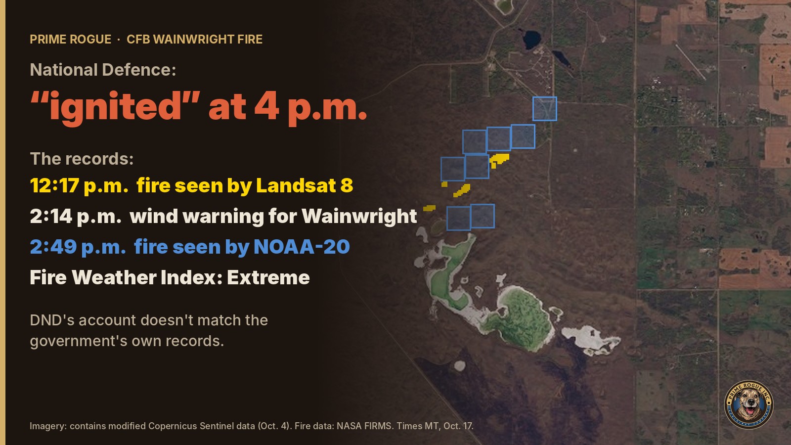
At 12:17 p.m. on Saturday, Oct. 17, a NASA satellite detected fire on the CFB Wainwright training area. At 2:14 p.m., Environment Canada extended a wind warning to the Wainwright region: a line of showers and weak thunderstorms was moving east, with gusts up to 100 km/h expected. Four were killed and 39 injured.
The fire was burning. The military says Range Control knew. The fire danger was Extreme. The wind change was forecast and then formally warned. Training continued.
On the evidence of the government’s own records, it was not safe to continue live training on the afternoon of Oct. 17 while a known fire burned on the range. This was not an unforeseeable act of weather. It was a decision, and the decision to keep training is the central question National Defence has not answered: who made it, on what information, and under what rules.
National Defence told the public something else. Its news release said a fire “ignited” at about 4 p.m. An internal CAF memo, reported by Global News, said the fire index was low and blamed an “unexpected and sudden” wind change. Each of those claims is contradicted, or left badly incomplete, by records kept by the Government of Canada, NASA and NOAA. Together they gave Canadians a misleading account of how four soldiers died: a sudden fire, low danger, a wind no one saw coming.
The record does not show whether that was deliberate, and we do not allege it was. The first release was written within hours of a mass-casualty event. What the record does show is that by Sunday afternoon National Defence’s own commander had described a fire known for hours, and National Defence still has not corrected a word. We name no individual as responsible; that is for investigators. The families of four soldiers are owed a public account that matches the record.
Every record in this story is public. The raw data is linked at the end so readers can check the work.
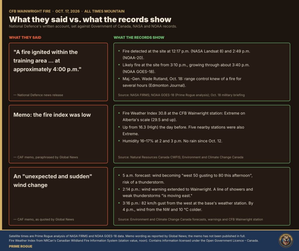
Both of National Defence’s news releases, and the memo, point the same way: toward a sudden, unforeseeable event. Here is what each one said, and what it left out.
| What National Defence told the public | What it left out |
|---|---|
| A fire “ignited within the training area” at “approximately 4:00 p.m.” – release, Oct. 18 | Fire was detected on the range at 12:17 p.m. Its own commander says Range Control knew of a fire for several hours. |
| “While conducting training a fire ignited and high wind speeds enabled the fire to grow and spread very rapidly” (second release, Oct. 18 | That the wind was forecast at 5 a.m. and warned of at 2:14 p.m., and that the fire danger was Extreme. |
| The fire index was low (memo, as reported by Global News | The federal government’s own Fire Weather Index for the base was Extreme. |
| An “unexpected and sudden” wind change (memo, same report) | Environment Canada had warned of strong gusts with high confidence, and narrowed the warning to Wainwright’s region at 3:05 p.m. |
An account that tells the public a fire started at the moment it turned deadly, in conditions no one could foresee, shifts the question away from the decisions made in the hours before. That is the effect of what National Defence has said, whatever the intent.
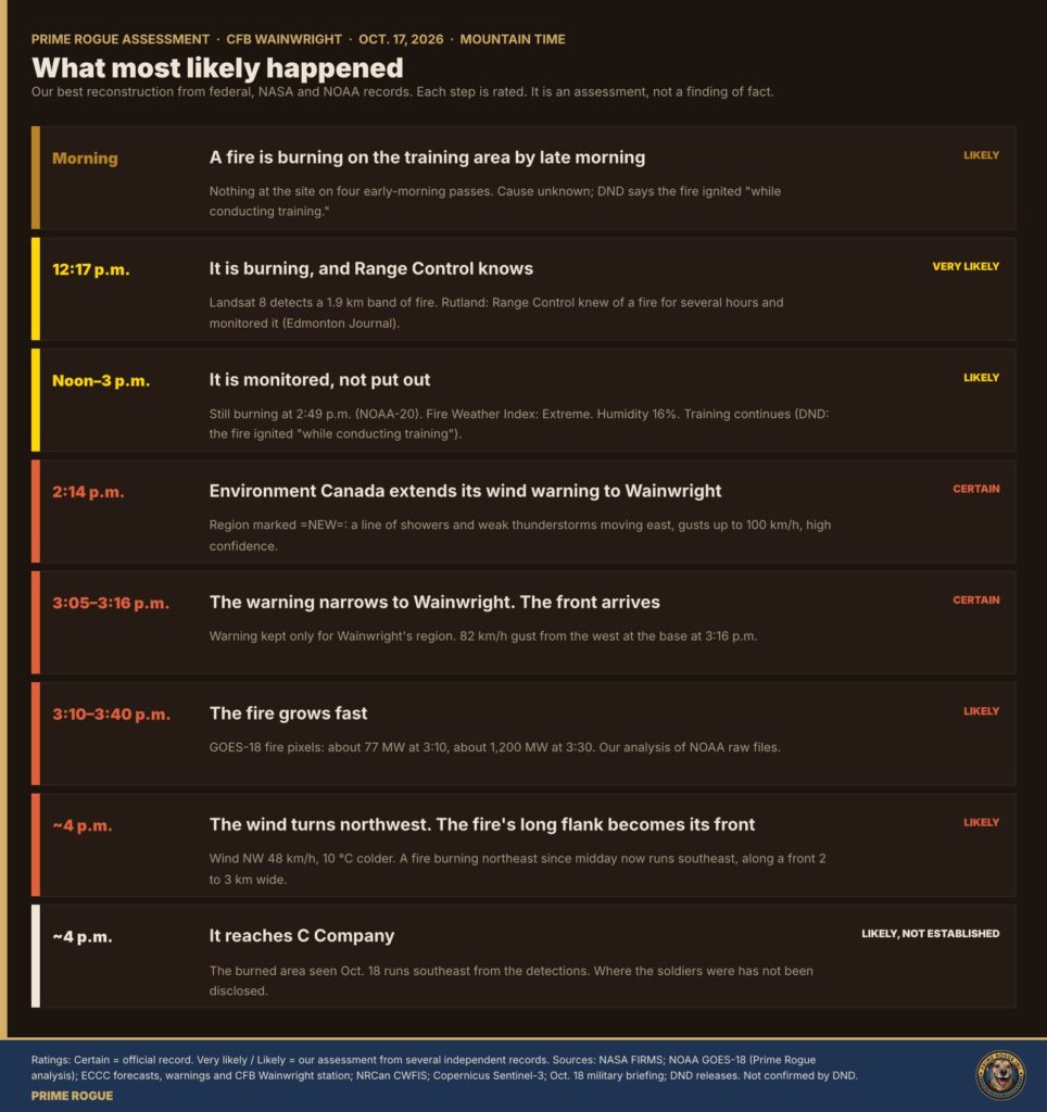
This is our reconstruction. Each step carries a confidence rating: “certain” where it comes straight from an official record, “very likely” or “likely” where it is our assessment from several independent records. It is not a finding of fact, and National Defence has not confirmed it.
This is our judgment, and here is what it rests on. While training continued that afternoon, every measure the federal government publishes pointed the same way:
Any one of these might be managed. Together, around a fire still burning at 2:49 p.m., they describe conditions in which a wind-driven grass fire can move faster than people on foot. Canadian Army ranges do tie training to fire danger. At Garrison Petawawa, for example, the 2019 range standing orders restrict which ammunition may be fired when the fire danger is Extreme, and allow “no firing of any ammunition of any type” at Extreme Plus. What Wainwright’s standing orders required that afternoon has not been disclosed. We have asked, and we are filing for them under the Access to Information Act.
The weather did not fail. The forecasts did not fail. On the record available, what failed was the decision to keep troops training while a known fire burned on the range, the fire danger was Extreme and a wind warning was in force. Who made that decision, and what they were told, is now the question.
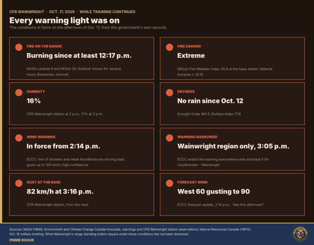
National Defence’s written account rests on three claims. Each is examined below.
National Defence’s Oct. 18 news release, “Incident at Canadian Forces Base Wainwright,” says: “A fire ignited within the training area of Canadian Forces Base (CFB) Wainwright, Alberta,” “at approximately 4:00 p.m. (local time) on October 17, 2026,” and “The fire spread rapidly beyond the boundaries of the training area.” A second release the same day, naming the soldiers, says: “While conducting training a fire ignited and high wind speeds enabled the fire to grow and spread very rapidly overtaking the unit administrative area.” As of Oct. 19, neither release had been corrected or updated.
At a briefing in Edmonton on Sunday, Maj.-Gen. Wade Rutland gave a different account. Range control was aware there was a fire for several hours and was monitoring it, Rutland said, according to the Edmonton Journal. “The fire was a kilometre away when the wind shifted,” he said, as reported by CTV News.
Fire was burning on the range for hours before 4 p.m.
Around 3:30 p.m., Wainwright resident Tanya Porter saw “a wall of smoke,” The Globe and Mail reported
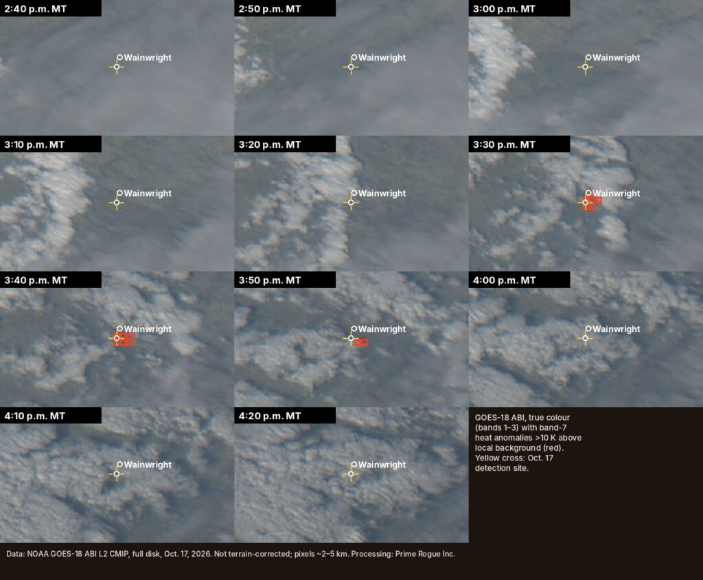
Other satellite passes that afternoon did not record fire at the site, including Suomi-NPP at about 2:29 p.m., NASA’s Aqua at about 3:15 p.m. and NOAA-21 at about 3:33 p.m. Cloud covered parts of the area. NOAA-20 detected the fire 20 minutes after the Suomi-NPP pass, so a miss under cloud is weak evidence that no fire was burning.
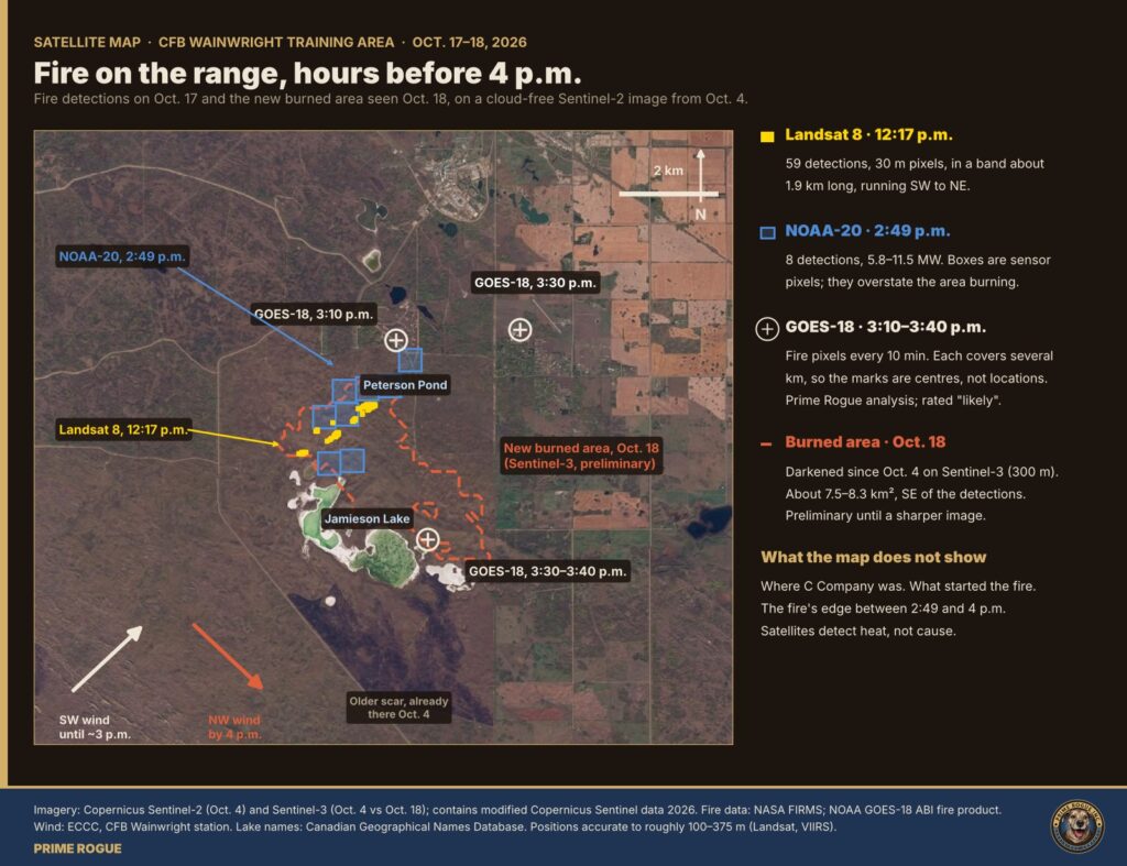
Read alone, “ignited” at 4 p.m. tells the public the fire started at the moment it became deadly. The satellite record shows a fire already burning for hours. The military’s own briefing says it was already known. The release has not been changed to say so.
It is likely, but not established, that the fire NASA detected is the fire that reached C Company. National Defence has not said.
A Strategic Joint Staff memo obtained by Global News said the fire index was low before the fire, according to Global’s report (https://globalnews.ca/news/12107414/fire-risk-was-low-before-sudden-wind-shift-sparked-deadly-base-fire-caf-memo/, follow). The same memo says: “During training, a grass fire ignited, and strong winds caused the fire to spread rapidly and shift direction.” The memo has not been published in full. National Defence has not said which index it meant, what its value was, or who set it.
Natural Resources Canada’s Canadian Wildland Fire Information System (CWFIS) publishes a daily Fire Weather Index for the weather station at CFB Wainwright. The Globe and Mail first reported the gap between the federal fire-danger data and the memo.
The daily index has limits: it is computed from noon weather and misses the afternoon peak. But on no reading of the federal data was the fire danger low.
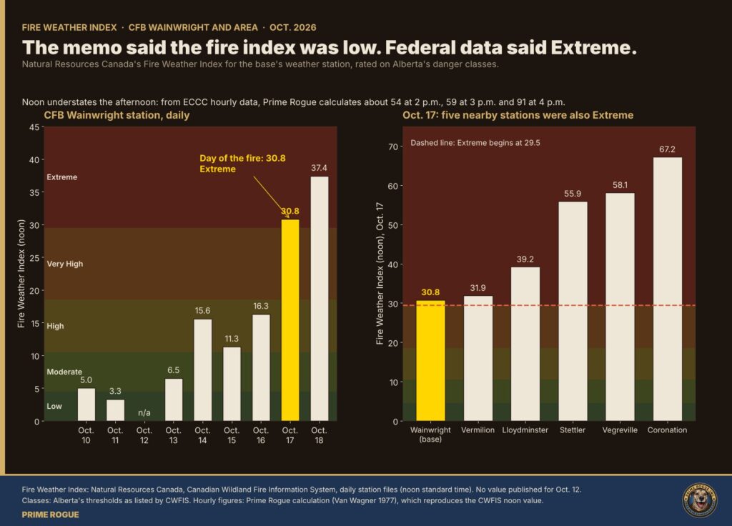
What the military said. The CAF memo reported by Global News described an “unexpected and sudden” wind change. At Sunday’s briefing, Rutland said winds were initially “well below 50 kilometres” an hour, according to The Epoch Times. Reuters reported he said winds were under 50 km/h before the fire. Rutland declined to say whether the incident was preventable, the Edmonton Journal reported. “And if our protocols need to change, then they’ll be updated,” he said, according to The Epoch Times.
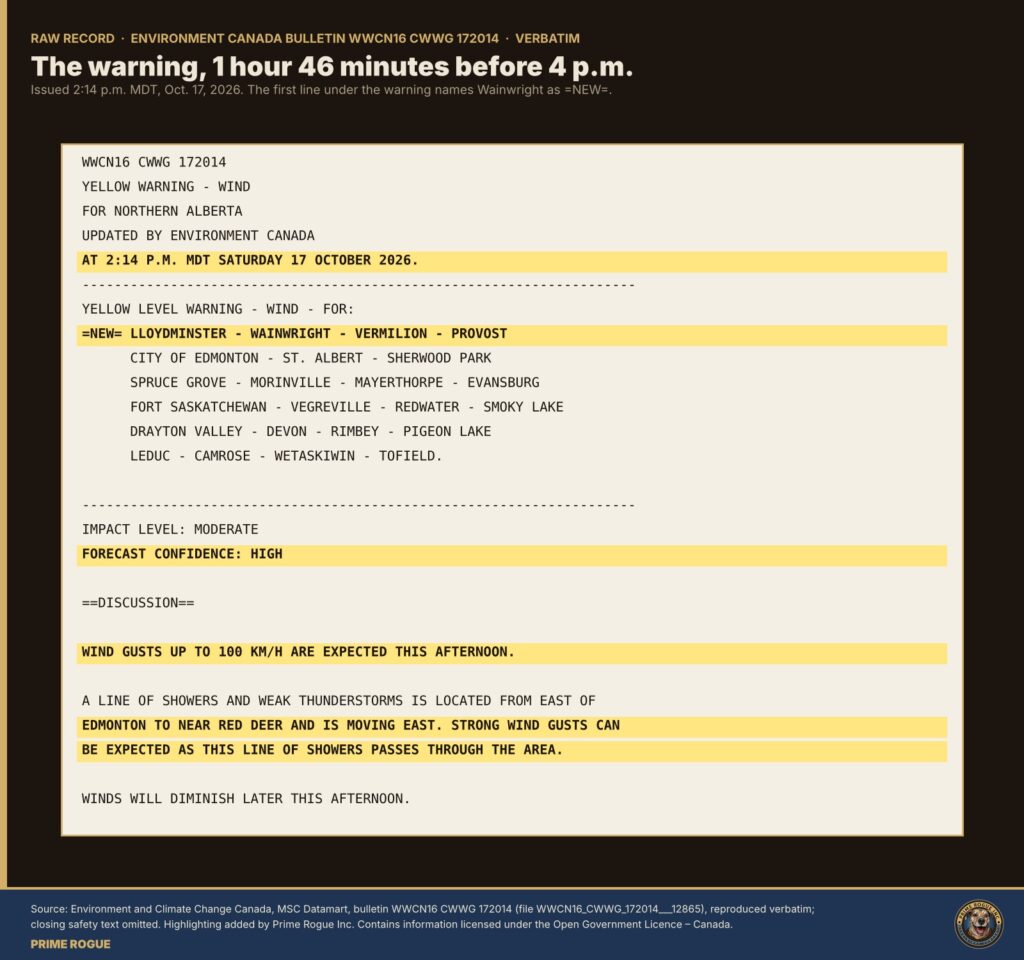
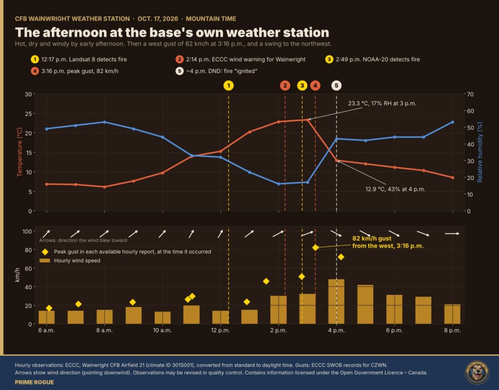
Environment and Climate Change Canada (ECCC) forecast strong wind that afternoon, warned of it before 4 p.m., and recorded it at the base. All forecast and warning text below is from the MSC Datamart.
| Time (Oct. 17) | Record | What it said |
|---|---|---|
| 5 a.m. | ECCC forecast, Lloydminster – Wainwright – Vermilion – Provost | Wind “southwest 30 km/h gusting to 50 this morning then west 50 gusting to 80 this afternoon,” with a risk of a thunderstorm. |
| 11 a.m. | ECCC forecast update | Similar strong west wind in the afternoon. |
| 2:14 p.m. | ECCC wind warning, extended to the Wainwright region (marked =NEW=) | “A line of showers and weak thunderstorms is located from east of Edmonton to near Red Deer and is moving east. Strong wind gusts can be expected as this line of showers passes through the area.” Gusts up to 100 km/h. Forecast confidence: high. |
| 2:48 p.m. | CFB Wainwright weather station | Gust of 51 km/h. |
| 3 p.m. | CFB Wainwright weather station | 23.3 C, humidity 17 per cent, southwest wind 32 km/h. |
| 3:05 p.m. | ECCC warning update | Warning ended for every other region and kept only for Lloydminster – Wainwright – Vermilion – Provost. Its text now read: “Wind gusts to 90 km/h are expected this evening.” |
| 3:16 p.m. | CFB Wainwright weather station | Peak gust of 82 km/h, from the west. |
| 4 p.m. | CFB Wainwright weather station | 12.9 C, humidity 43 per cent, northwest wind 48 km/h. |
Lloydminster’s station, about 80 km northeast of the fire site, recorded wind to 98 km/h between 3 and 4 p.m.
The forecasts did not give the minute the wind would change, and they called for west wind rather than northwest. But strong west wind and a risk of thunderstorms were forecast at 5 a.m. The line of showers and weak thunderstorms that brought the gusts was the subject of a warning nearly two hours before 4 p.m., and the gusts were measured at the base’s own station by 3:16 p.m.
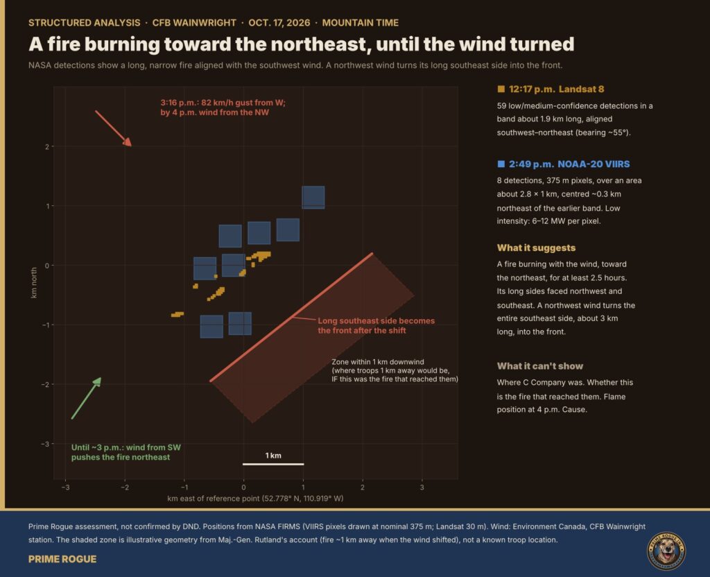
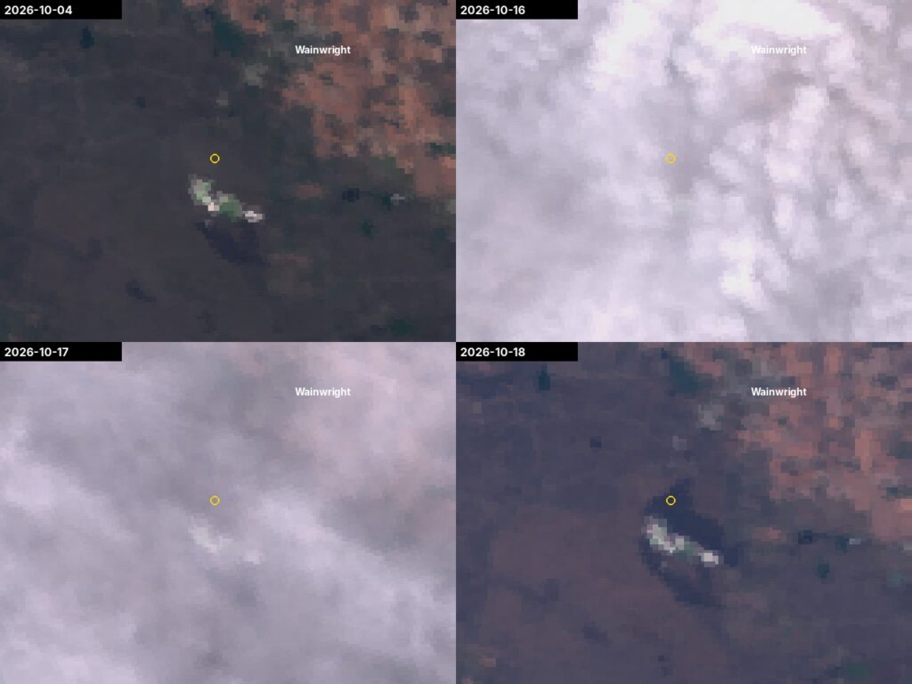
A Sentinel-3 image from Oct. 18, compared with one from Oct. 4, shows a newly darkened area of about 7.5 to 8.3 square kilometres. It begins at the Oct. 17 detections and runs southeast for about 5 km, roughly 2.5 to 3 km wide. That is the direction a northwest wind would drive a fire.
This is preliminary. Sentinel-3 pixels are 300 m across, and some darkening may be seasonal. We will publish a sharper measurement when a clear Sentinel-2 or Landsat image is available.
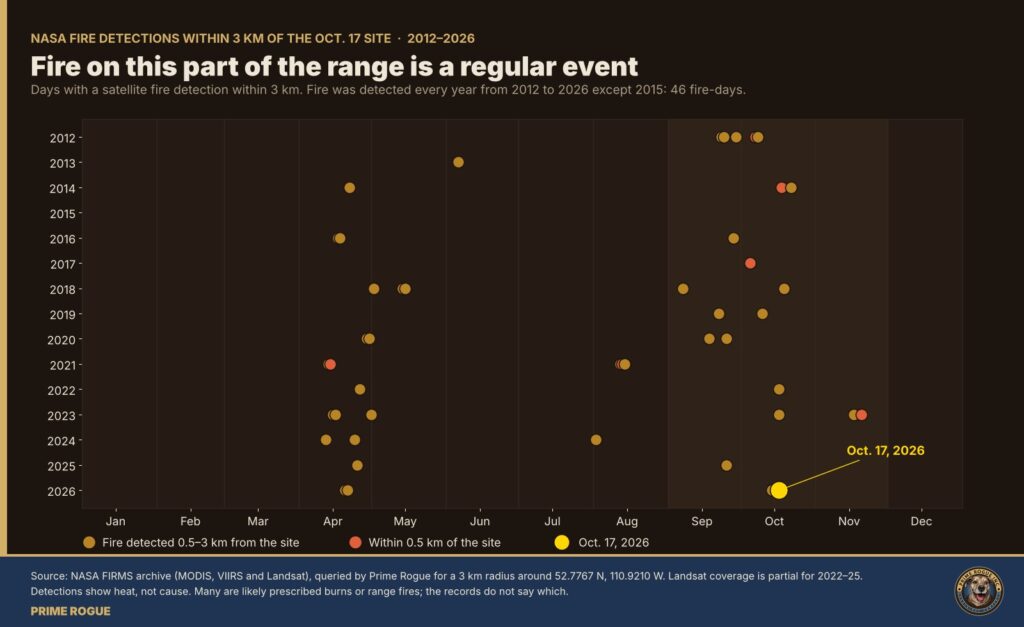
NASA’s archive shows fire detected within 3 km of the Oct. 17 site every year from 2012 to 2026 except 2015, on 45 separate days before Oct. 17, mostly in April and from September to November. Several were within half a kilometre, including Oct. 6, 2012, Oct. 18, 2014, and Oct. 5, 2017. On Oct. 14 this year, three days before the fire, NOAA-21 detected fire on the west shore of Jamieson Lake.
Satellites detect heat, not cause. Many of these are likely prescribed burns or range fires, and the records don’t say which. The pattern raises a question for investigators: was a fire burning on this part of the range treated as normal?
Rutland said the fire was about a kilometre away when the wind shifted. “It is not normal for a fire to move a kilometre in 30 to 60 seconds,” he said, as reported by CTV News.
A kilometre in 30 to 60 seconds is 60 to 120 km/h. That is between about three-quarters of and one and a half times the strongest gust recorded at the base, 82 km/h. A 2022 study of 58 grassland wildfires in southern Australia under critical burning conditions found that “the forward rate of fire spread is approximately 20% of the average 10-m open wind speed” (Cruz, Alexander and Kilinc, Fire, 2022). At the 4 p.m. average of 48 km/h, that is about 10 km/h, or six minutes per kilometre. Even using the 82 km/h peak gust instead of the average, it is about 16 km/h, or roughly four minutes per kilometre.
This does not tell us what happened. It means at least one part of the account needs explaining. The fire may have been closer than a kilometre when the wind changed. The soldiers may have been in its path for longer than a minute. Or the distance and the time describe something else, such as spot fires thrown ahead by the wind. National Defence has not said which.
Those answers sit in records National Defence holds: the Range Control log, range bookings and danger-area maps, the Wainwright range standing orders, and the weather briefings the exercise received.
Prime Rogue sent National Defence a summary of these findings and five questions at 0216 AM, after several previous unanswered requests for comment, with a deadline of 8 a.m. ET (6 a.m. MT) today. National Defence did not respond by the deadline. We will add any later response to this story.]
Prime Rogue is also filing requests under the Access to Information Act for the Range Control log, the range standing orders, the daily fire-danger ratings used on the range, the weather briefings received on Oct. 16 and 17, and the range bookings for Oct. 17.
According to the CAF memo reported by Global News, Canadian Forces National Investigation Service investigators were sent to Wainwright, and the RCMP offered support. Asked about a board of inquiry, Rutland said, “I would come back in at least a month,” CTV News reported.
These are the unprocessed satellite images behind the analysis, as delivered.
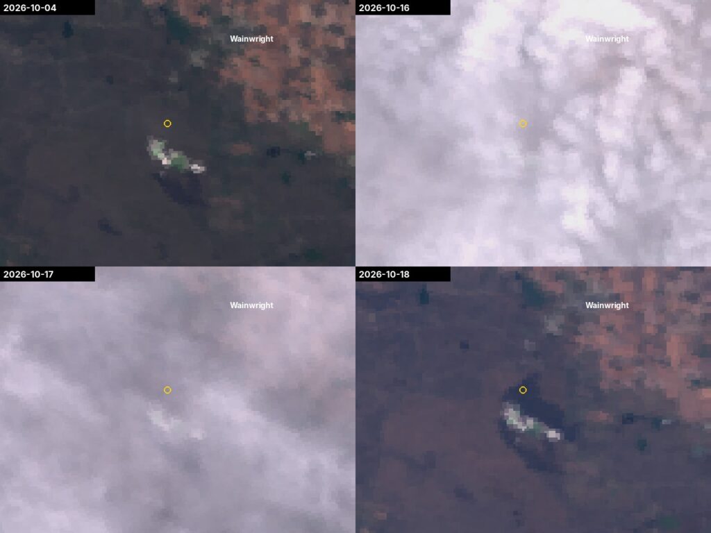
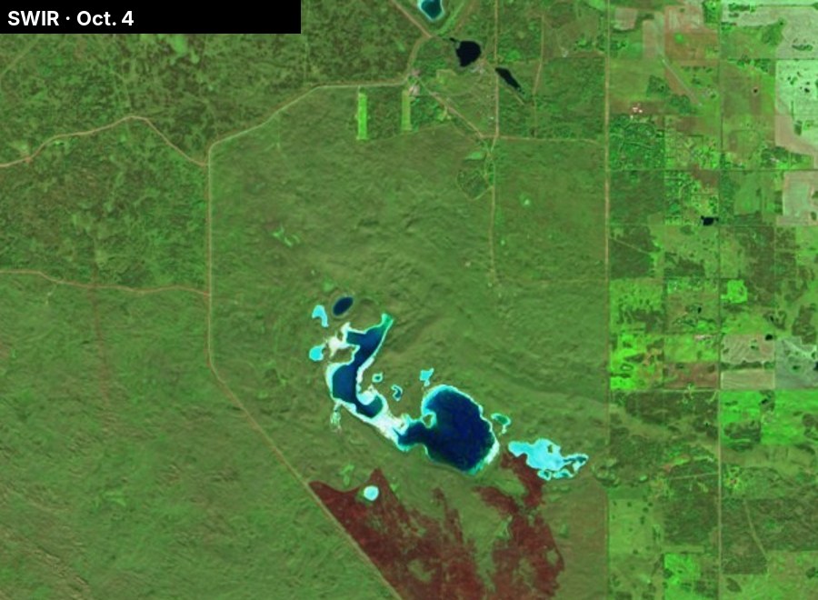
The full set, including every GOES-18 frame, the Sentinel-2 bands and NASA’s original files, is in the raw-data package linked below.
Every record in this story is public. Fire detections come from NASA FIRMS (Landsat 8 OLI, NOAA-20 VIIRS) and from NOAA’s GOES-18 fire product, which Prime Rogue read from NOAA’s public archive. Weather records are ECCC forecasts and warnings and hourly observations for the CFB Wainwright station (climate ID 301S001; CZWN). Fire-danger data is Natural Resources Canada’s CWFIS daily station files. Imagery is Copernicus Sentinel-2 and Sentinel-3. Times are converted to Mountain Time.
We use estimative language. “Certain” means the fact comes directly from an official record. “Very likely” means several independent records agree. “Likely” means the evidence points one way, but rests partly on our own analysis or on fewer sources. “High confidence” in our overall assessment means the conclusion holds across those ratings. The raw NASA data, with checksums, is in our raw data package. The full analysis is here.
Sgt. Morgan Wong of the Loyal Edmonton Regiment, serving with 3 PPCLI, and Pte. Shaun Farrell, Pte. Aidan Goulding and Pte. Hayden Lykkemark of 3 PPCLI were killed. National Defence said. 39 Canadian Armed Forces members were injured. Prime Rogue’s thoughts are with their families and with the people of Wainwright.
 A week of satellite data on the CFB Wainwright fire: burning by 2:49 p.m., likely since morning
 Satellites saw fire on CFB Wainwright range hours before DND says it ignited
 Satellite record fits scenario that an exercise fire was burning before the CFB Wainwright incident
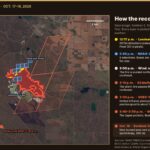 The storm line, then the fire: every satellite record of the CFB Wainwright fire, on one map


[…] fire was almost certainly burning on the CFB Wainwright range by 2:49 p.m. on Oct. 17, more than an hour before the wind turned. It was very likely burning […]
[…] and Climate Change Canada, forecasts, warnings and hourly observations, CFB Wainwright, Oct. 17, 2026 – Archived – Links Currently […]
[…] full reconstruction of Oct. 17, with 13 graphics and the raw records, is here: Every warning light was on. Follow developments on our live updates […]
[…] full reconstruction of the afternoon sets out the fire, weather and warning […]
[…] Environment Canada’s nearby Lloydminster Airport station recorded clear or mainly clear skies every hour from midnight to 4 a.m. The CFB Wainwright station does not report […]
[…] Time (MDT)Satellite and sensorResolutionResult at CFB Wainwright […]
[…] in which an exercise fire set off a gas well.Original analysis (2 a.m. MT) · Follow-up (7 a.m. MT) Latest Report (10/19 – 0600 […]