Address
304 North Cardinal St.
Dorchester Center, MA 02124
Work Hours
Monday to Friday: 7AM - 7PM
Weekend: 10AM - 5PM

Address
304 North Cardinal St.
Dorchester Center, MA 02124
Work Hours
Monday to Friday: 7AM - 7PM
Weekend: 10AM - 5PM
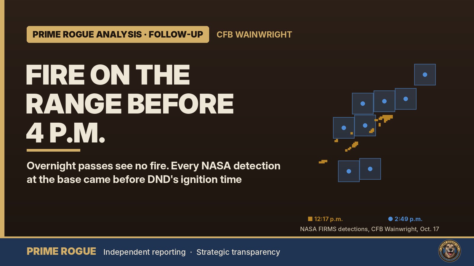
This follows Prime Rogue’s analysis published at 02:00 a.m. MT: Satellites saw fire on CFB Wainwright range hours before DND says it ignited.
A scenario now being raised on national television, that a fire from Saturday’s training exercise at CFB Wainwright set off a gas well, fits the NASA satellite record Prime Rogue published overnight.
That record shows fire in the base’s training area at 2:49 p.m., and likely as early as 12:17 p.m., before the roughly 4 p.m. time the Department of National Defence says a fire “ignited.” Four more satellite passes overnight, reviewed by Prime Rogue, detected no active fire at the base, where officials say the fire is being held.
Across about 16 hours of NASA’s polar-orbiting satellite passes, from midday Saturday to before dawn Sunday, every fire detection recorded at the base came before 4 p.m.
Early Sunday, CBC News senior defence writer Murray Brewster said on air, live on CBC News Network, that it is possible a fire that was part of the exercise set off a gas well, which he said would explain the chain of events. He said the scenario had not been confirmed by authorities.
On Saturday night, Global News reported, citing multiple Canadian Armed Forces sources, that a live-fire training exercise hit a gas line or gas well on the base, causing an explosion around 4 p.m. The base sits on an active gas field; The Western Producer has reported about 180 gas wells within the base boundaries.
Neither account has been confirmed. DND has not named a cause, and its news release does not mention an explosion.
If the scenario is right, the satellite detections are the start of the chain of events rather than a contradiction of DND’s timeline. Fire was on the range, in the area where the incident occurred, for at least an hour before 4 p.m. That would make the central question when the earlier fire started, whether it was being managed, and what happened at 4 p.m. that DND describes as the moment a fire “ignited.”
Satellites detect heat, not cause. Fire on an active training range can come from the exercise itself, from controlled burning, or from other sources. The detections cannot show whether the earlier fire and the 4 p.m. event are connected. Only DND can answer that.

Prime Rogue analyzed NASA Fire Information for Resource Management System (FIRMS) data downloaded at 4:27 a.m. MT. Four passes by VIIRS instruments, which detect heat from active fires at a resolution of about 375 metres, appear to have covered the base:
None recorded a fire detection within 40 kilometres of the base. Each recorded fires elsewhere in Alberta and Saskatchewan on both sides of Wainwright within the same minute, and an independent calculation of the satellites’ orbits places the base inside each pass’s coverage.
Conditions were favourable. Satellites detect fires more easily at night, when the surrounding ground is cool. Environment Canada’s nearby Lloydminster Airport station recorded clear or mainly clear skies every hour from midnight to 4 a.m. The CFB Wainwright station does not report cloud.
The result is consistent with what local officials have said. In a post on its website at 10:47 p.m. Saturday, the Municipal District of Wainwright said: “The wildfire south of Wainwright is being held at this time.” It added that “a fire watch will remain in place to monitor the affected area.” Officials have not said the fire is out. Satellites cannot rule out smouldering ground fire or small hot spots, and three of the four passes viewed the base at an angle, which makes small fires harder to see.
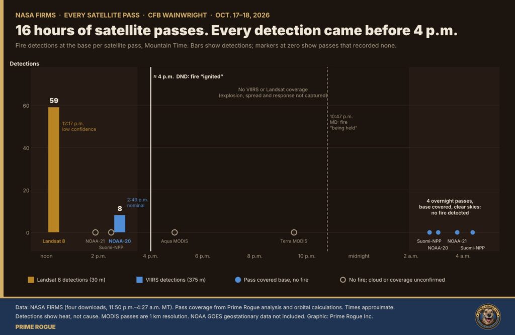
Prime Rogue downloaded NASA’s data four times between 11:50 p.m. Saturday and 4:27 a.m. Sunday. Every download contains the same detections at the base, and only those. NASA did not revise, add or remove any of them overnight.
Prime Rogue also checked each detection time against the rest of the satellite’s pass in NASA’s raw files. Landsat 8 recorded fires in a north-to-south sequence, minute by minute, with Wainwright in its 12:17 p.m. slot. NOAA-20 recorded fires south to north, with Wainwright in its 2:49 p.m. slot. Both times match each satellite’s path and time of day.
The Canadian Armed Forces’ first statement said “a fire was reported on the range” at approximately 1600. DND’s news release, dated Oct. 18, said “a fire ignited within the training area” at approximately 4:00 p.m. The 2:49 p.m. detections came about 70 minutes before that; the 12:17 p.m. detections, if confirmed, about three hours and 40 minutes before.
By Prime Rogue’s analysis of orbital data, no VIIRS or Landsat pass covered the base between about 3:30 p.m. and nightfall. Two coarser MODIS passes, at about 4:55 p.m. and 9:30 p.m., recorded nothing there. NOAA’s geostationary GOES satellites scan the region every 10 minutes at about two-kilometre resolution; that data is not part of this analysis.
NASA’s FIRMS data therefore does not capture the explosion, the fire’s spread past the base fence, or the response. By the time the overnight passes came, officials said the fire was held.
Cloud also matters. The Lloydminster station recorded mostly cloudy skies through Saturday daytime, which may explain why two other afternoon passes, at about 1:52 p.m. and 2:29 p.m., recorded no fire at the base.
NASA’s fire maps of the base have since appeared in broadcast coverage. NASA’s timestamps show the detections on those maps were recorded at 12:17 p.m. and 2:49 p.m., before the reported incident. They do not show the explosion or the fire’s spread afterward.
Prime Rogue has asked National Defence:
As of publication, DND, the RCMP, Alberta Health Services, the MD of Wainwright, STARS and Alberta Wildfire had not responded to Prime Rogue’s specific questions. Several have issued public statements: DND its news release, the RCMP a release saying officers responded to a request for assistance at about 4 p.m., the MD three incident updates, and STARS a confirmation that its Edmonton and Saskatoon aircraft responded to the Wainwright area.
Prime Rogue has also filed access-to-information requests with DND for Range Control logs, dispatch records and communications about the timeline.
Defence Minister David McGuinty confirmed “both fatalities and injuries” at a news conference in Ottawa on Saturday evening but did not give numbers. Global News, citing multiple military sources, reported at least seven people killed and dozens injured. The CAF said it “will not confirm casualty or injury details” until next of kin have been notified.
Acute Care Alberta said a Code Orange was activated at several acute care facilities across the province late Saturday, including Edmonton’s University of Alberta and Royal Alexandra hospitals. Saskatchewan Premier Scott Moe said his province “has deployed resources to Alberta and is ready to provide more if required.” He did not say what was sent.
The Globe and Mail reported that around midnight, seven CAF members parachuted onto the high-school field beside the Wainwright hospital with medical equipment.
McGuinty said the RCMP is involved in the investigation. No military police, Canadian Forces National Investigation Service or Board of Inquiry announcement had been made as of publication.
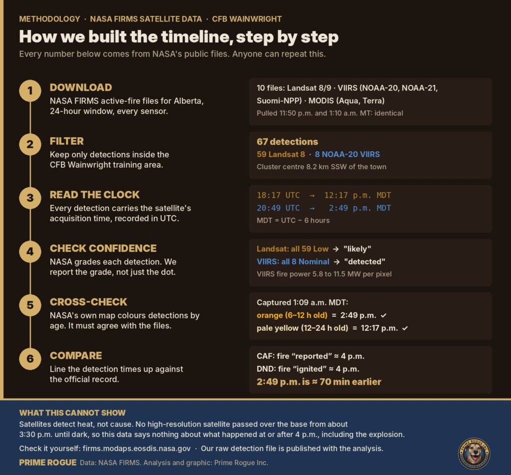
Prime Rogue downloaded NASA FIRMS 24-hour active-fire files for Canada and Alberta, covering every sensor FIRMS provides, four times between 11:50 p.m. Saturday and 4:27 a.m. Sunday. We extracted every detection within 40 km of the base, removed duplicates, and converted NASA’s UTC timestamps to Mountain Daylight Time (UTC minus six hours). To check coverage, we compared each overnight pass’s detections on either side of the base and cross-checked pass times against orbital calculations. Full methodology is in our original analysis.
Every detection at the base, as recorded in NASA’s files (de-duplicated by coordinates; identical in all four downloads):
| Sensor | NASA timestamp (UTC) | Mountain time | Detections | Confidence | Fire radiative power |
|---|---|---|---|---|---|
| Landsat 8 OLI (30 m) | 2026-10-17 18:17 | 12:17 p.m. Oct. 17 | 59 | Low (all) | not reported for Landsat |
| NOAA-20 VIIRS (375 m) | 2026-10-17 20:49 | 2:49 p.m. Oct. 17 | 8 | Nominal (all) | 5.83–11.53 MW per pixel |
| Latitude | Longitude | Time (UTC) | Confidence | FRP (MW) |
|---|---|---|---|---|
| 52.76859 | -110.92699 | 20:49 | Nominal | 11.53 |
| 52.76907 | -110.91988 | 20:49 | Nominal | 11.33 |
| 52.77745 | -110.92869 | 20:49 | Nominal | 7.77 |
| 52.77793 | -110.92152 | 20:49 | Nominal | 5.83 |
| 52.78236 | -110.92231 | 20:49 | Nominal | 7.65 |
| 52.78284 | -110.91513 | 20:49 | Nominal | 7.65 |
| 52.78333 | -110.90795 | 20:49 | Nominal | 11.42 |
| 52.78825 | -110.90158 | 20:49 | Nominal | 11.42 |
| Satellite | NASA timestamps (UTC) | Mountain time | Base within coverage | Detections within 40 km of base |
|---|---|---|---|---|
| Suomi-NPP VIIRS | 08:41–08:43 | about 2:42 a.m. | Yes, at a high viewing angle | 0 |
| NOAA-20 VIIRS | 09:01–09:05 | about 3:02 a.m. | Yes | 0 |
| NOAA-21 VIIRS | 09:44–09:49 | about 3:46 a.m. | Yes, nearly overhead | 0 |
| Suomi-NPP VIIRS | 10:21–10:26 | about 4:22 a.m. | Yes | 0 |
All 59 Landsat detections, with coordinates, are in the downloadable CSV. The raw NASA files, unmodified and with checksums, are available here: [PROTON DRIVE LINK].
daytime satellite passes on Sunday, including a Suomi-NPP pass predicted to be nearly overhead at about 2:10 p.m. MT, should show any remaining hot spots and, in clear skies, the burned area. Prime Rogue will report what they show.
Ongoing coverage: CFB Wainwright fire: live updates.
CAF Family Information Line (24/7): 1-800-866-4546. Canadian Forces Member Assistance Program: 1-800-268-7708. The MD of Wainwright directs families seeking information to DND Public Affairs at 819-531-8618.
 Satellites saw fire on CFB Wainwright range hours before DND says it ignited
 LIVE: Deaths and injuries after fire at CFB Wainwright as wind-driven blaze crosses base fence
 Canada’s Military Playbook for the 2025 Kananaskis G7 Summit – 2025 G7 Security Series #2
 Canada’s 300,000-Person Reserve Plan: What’s Actually Happening | Prime Rogue



[…] satellites detected fire on the CFB Wainwright training range on Saturday afternoon, hours before the time the Department of National Defence says […]
[…] Incident records […]
[…] Rogue published its full analysis of NASA satellite fire data for CFB Wainwright, including methodology and the raw detection file. Satellites saw fire on CFB Wainwright range […]