A fire started by artillery shooting into the Lawfield Impact Area burned through part of the CFB Gagetown training area in New Brunswick on Oct. 28 and was still burning the next afternoon. The base says it was reported to Range Control at 12:22 p.m. ADT, during a Royal Canadian Artillery School course firing the 105 mm LG1 howitzer, under a Moderate fire-danger rating. No one was hurt. Public satellite data shows how it unfolded, hour by hour.
It came eleven days after the fire at CFB Wainwright, Alta., where four soldiers died and 39 were injured on Oct. 17.
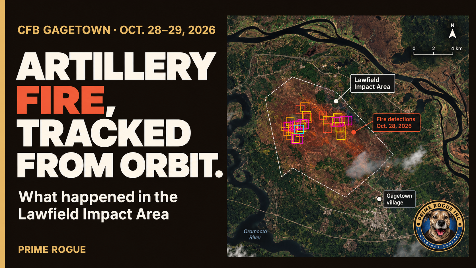
Where the Fire at CFB Gagetown Occured on October 28, 2026.
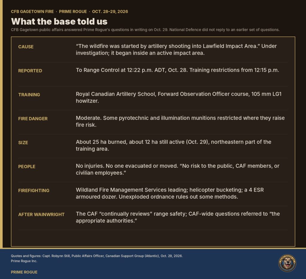
What the base says happened
CFB Gagetown’s public affairs office answered Prime Rogue’s questions in writing on Oct. 29. National Defence did not reply to an earlier set of questions sent to the department by its noon deadline on Oct. 29.
Cause. “The wildfire was started by artillery shooting into Lawfield Impact Area,” wrote Capt. Robynn Still, public affairs officer for Canadian Support Group (Atlantic). As the fall of artillery shot is done under observation, the detection of this fire would have occurred very rapidly after its ignition.” The cause “remains under investigation,” she added, but the fire “originated within an active impact area of the training range.
When. “The fire was reported to Range Control at 1222 hrs on 28 October.” Training restrictions were put in place at 12:15 p.m.
Who was firing. “At the time the wildfire was reported, Royal Canadian Artillery School (RCAS) Forward Observation Officer (FOO) Course was conducting training involving the 105 mm LG1 howitzer.” All training near the fire was then suspended.
Fire danger. “A fire danger rating of Moderate was in effect on October 28.” Under the range safety orders, the base said, there were restrictions on “certain pyrotechnic and illumination munitions in areas where they could increase fire risk.” The base said the training “was carried out in accordance with those requirements.”
Size. On Oct. 29, about 25 hectares had burned, with about 12 hectares still actively burning, “in the northeastern portion of the Gagetown Range and Training Area.”
Safety. No one had to evacuate or move, and there were no injuries. There was “currently no risk to the public, Canadian Armed Forces members, or civilian employees.”
Firefighting. Wildland Fire Management Services is leading the response. Helicopter water-bucket drops were planned for the afternoon of Oct. 29, and an armoured dozer from 4 Engineer Support Regiment was being brought in. “Due to the presence of unexploded ordnance within portions of the training area, some suppression methods cannot be used in affected areas.”
After Wainwright. Asked whether anything had changed since Oct. 17, the base said the Armed Forces “continually reviews wildfire mitigation measures, range safety procedures, and training practices,” and referred CAF-wide questions to “the appropriate authorities.”
One point in the answers needs clearing up. The base describes Wildland Fire Management Services in one answer as “New Brunswick’s provincial wildfire agency” and in another as “a base organization independent of the Base Fire Services.”What the satellites saw
The fire was visible from orbit for most of two days. Three kinds of public satellite data, read together, give the sequence. Times are ADT.
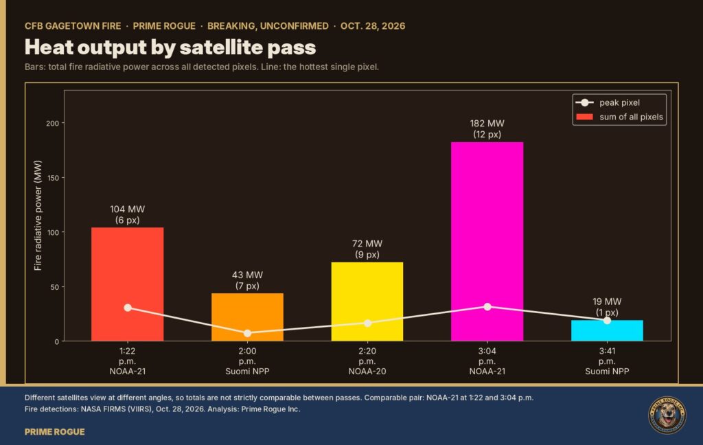
Various satellite passes show the intensification of the CFB Gagetown Fire
Oct. 28, midday: first heat
GOES-19, the U.S. weather satellite that images eastern North America every five minutes, recorded its first heat over the area at 12:46 p.m. That’s 24 minutes after the time the base gives for the report to Range Control. Its first measured fire power came at 12:50–12:51 p.m., 52–58 megawatts.
The area was mostly cloud-covered all afternoon, so GOES saw the fire only through gaps. Its pixels are about 3 km across here: it can confirm a fire, not draw it.
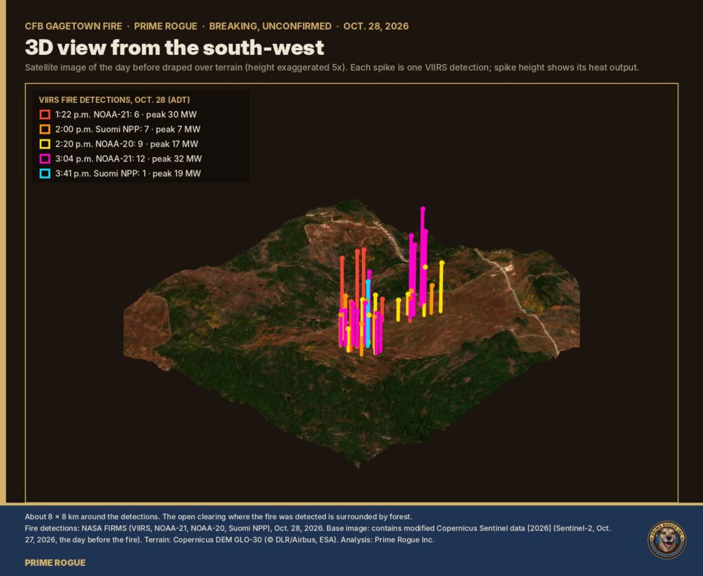
The fire at CFB Gagetown was significant ans sprawling.
Oct. 28, afternoon: five passes
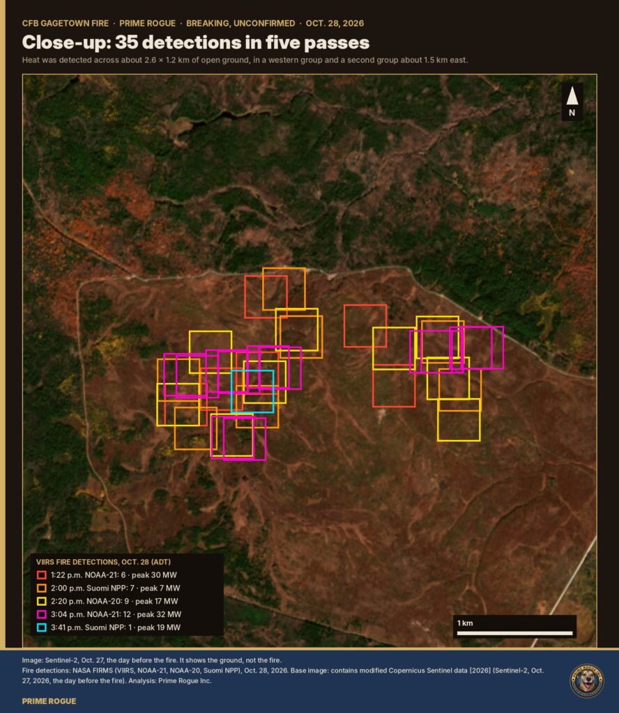
NASA’s three VIIRS satellites passed five times between 1:22 and 3:41 p.m. and recorded 35 fire detections:
1:22 p.m.
NOAA-21
6
30.5
2:00 p.m.
Suomi NPP
7
7.4
2:20 p.m.
NOAA-20
9
16.6
3:04 p.m.
NOAA-21
12
31.5
3:41 p.m.
Suomi NPP
1
19.1
Peaks. GOES-19’s highest reading was 112 MW at 3:26 p.m. It stopped seeing flame after 3:41 p.m.
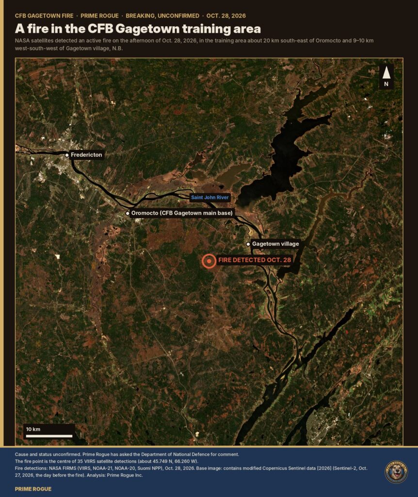
Where. The detections sat in one large, open clearing of heath and brush, ringed by a track and surrounded by forest. They spread across about 2.6 km east to west and 1.2 km north to south, around 45.749 N, 66.260 W. That’s about 9–10 km west-south-west of Gagetown village and about 20 km south-east of Oromocto.
Reading the spread. VIIRS pixels are about 375 metres across, so this is the area where heat was detected, not the outline of what burned. The base’s 25-hectare figure is far smaller than the spread of the pixels, which is normal: one fire front lights up several overlapping pixels.
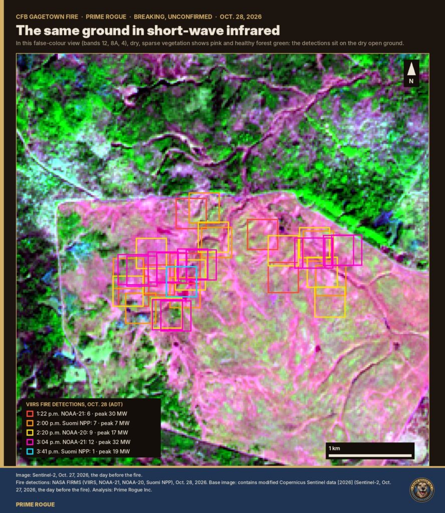
At least 35 fire clusters were present on the CFB Gagetown base. The October 28th fire at CFB Gagetown covered dry terrain.
In short-wave infrared, the clearing shows as dry, sparsely vegetated ground, and every detection sits on it. The forest around it shows green.
Overnight: still warm
VIIRS night passes at 3:57 and 4:15 a.m. on Oct. 29 found four more pixels, each 1–2 MW. That’s smouldering or a small residual front, not an active run.
Oct. 29: back up
GOES-19 saw flame again from 12:11 to 12:51 p.m. at about 40–46 MW, and once more at 4:30 p.m.
Five VIIRS passes between 1:05 and 3:21 p.m. found 13 detections, peaking at 12 MW, about a third of the first day’s intensity.
Every one sat on the southern side of the first day’s area, up to about 0.8 km beyond it. That suggests slow spread to the south, though pixel positions shift a few hundred metres between passes.
None was recorded after 3:21 p.m. through to early Oct. 30.
The burn itself hasn’t been seen yet
The only clear optical image since the fire, a Sentinel-2 pass at 12:30 p.m. on Oct. 29, ends at the edge of its tile about 3 km west of the fire. The last clear image of the clearing is still the one from Oct. 27, the day before.
Unusual for the place
In the 60 days before Oct. 28, the same satellites recorded just one small detection anywhere in the training area: two pixels on Sept. 22, about 11 km to the north-west.
How the story broke
[IMAGE TO INSERT] Timeline of how the CFB Gagetown fire story broke, from the 12:22 p.m. report to Range Control to the base’s written answers
12:22 p.m., Oct. 28: fire reported to Range Control, per the base.
12:46 p.m.: first heat from orbit (GOES-19).
1:22 p.m.: first NASA FIRMS (VIIRS) detections.
5:21 p.m.:Roger Wilco Imagery, Prime Rogue’s open-source satellite-monitoring service, flagged the fire automatically as a new heat source on a military base. It listed it on its public site that evening.
About 9:49 p.m.: CFB Gagetown posted a statement on Instagram. It said a wildfire was burning in the northeastern sector of the training area, monitored by Wildland Fire Management Services, with no threat to nearby communities, and that training nearby was suspended.
Late Oct. 28:The Canadian Press reported the fire, citing defence officials who said it was no threat to the public.
Morning of Oct. 29: Roger Wilco Media wrote up the satellite timeline in SITREP 017: GOES-19’s first heat, the five passes, the peak and the spread. It flagged that the cause had not been given. A build failure on its site kept the report offline until that evening.
Oct. 29, during the day: the Fredericton Independent reported the base’s statement. The base’s afternoon update to reporters gave the cause and the 25-hectare figure (CBC News; Fredericton Independent). Roger Wilco Imagery’s SITREP 018 followed that night with the second day’s detections.
Reports disagree on the fire’s status on Oct. 29. The Canadian Press described it as under control. The base’s own answers say it “remains active.”
Why the timing matters
Wainwright still hangs over every range fire.
The Oct. 17 fire there started on an automatic grenade launcher range, and a wind shift drove it onto soldiers on a nearby range. Roger Wilco Imagery’s satellite analysis put the first heat about 70 minutes before the ignition time officials first gave.
At Gagetown the picture is different: the fire was in an impact area, no one was in its path, and the base says it was seen and reported almost at once.
But some of the same questions apply:
why live artillery was firing into dry autumn ground under a Moderate rating;
what the 12:15 p.m. restrictions covered;
what, if anything, changed after Wainwright.
The base answered the first in general terms and referred the last to “the appropriate authorities.”
Sources and method
Fire detections: NASA FIRMS (VIIRS on NOAA-21, NOAA-20 and Suomi NPP), near-real-time, Oct. 27–30.
GOES-19: the NOAA ABI fire product, via NOAA Open Data on AWS. The five-minute series was assembled by Roger Wilco Media.
Imagery: Sentinel-2, Oct. 27 (contains modified Copernicus Sentinel data [2026]).
Terrain: Copernicus DEM GLO-30.
Fire radiative power measures heat output, not area burned.
Raw data and code: every number above can be checked against the unaltered FIRMS responses, the merged tables and the scripts in Prime Rogue’s public repository, DND-BASE-FIRES-Beginning-10-28-2026.
Disclosure: Roger Wilco Imagery is run by Prime Rogue Inc.

 Satellites saw fire on CFB Wainwright range hours before DND says it ignited
 Satellite record fits scenario that an exercise fire was burning before the CFB Wainwright incident
 Another sign pointing away from gas: what satellites and the regulator show about CFB Wainwright’s gas lines
 CFB Wainwright Fire: The Flank Became The Front


