Address
304 North Cardinal St.
Dorchester Center, MA 02124
Work Hours
Monday to Friday: 7AM - 7PM
Weekend: 10AM - 5PM

Address
304 North Cardinal St.
Dorchester Center, MA 02124
Work Hours
Monday to Friday: 7AM - 7PM
Weekend: 10AM - 5PM
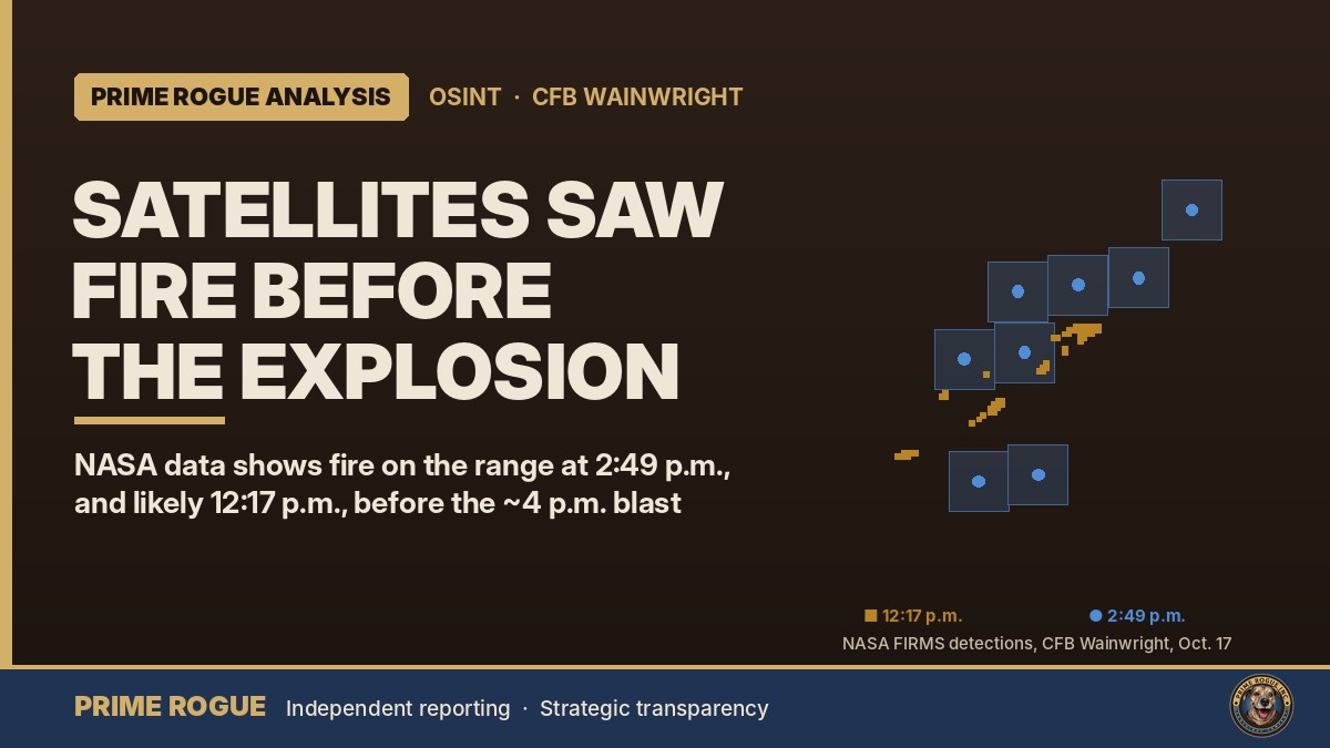
Satellites saw fire on CFB Wainwright range hours before DND says it ignited
NASA satellites detected fire on the CFB Wainwright training range on Saturday afternoon, hours before the time the Department of National Defence says the fire ignited, and before the explosion that military sources told Global News happened at around 4 p.m.
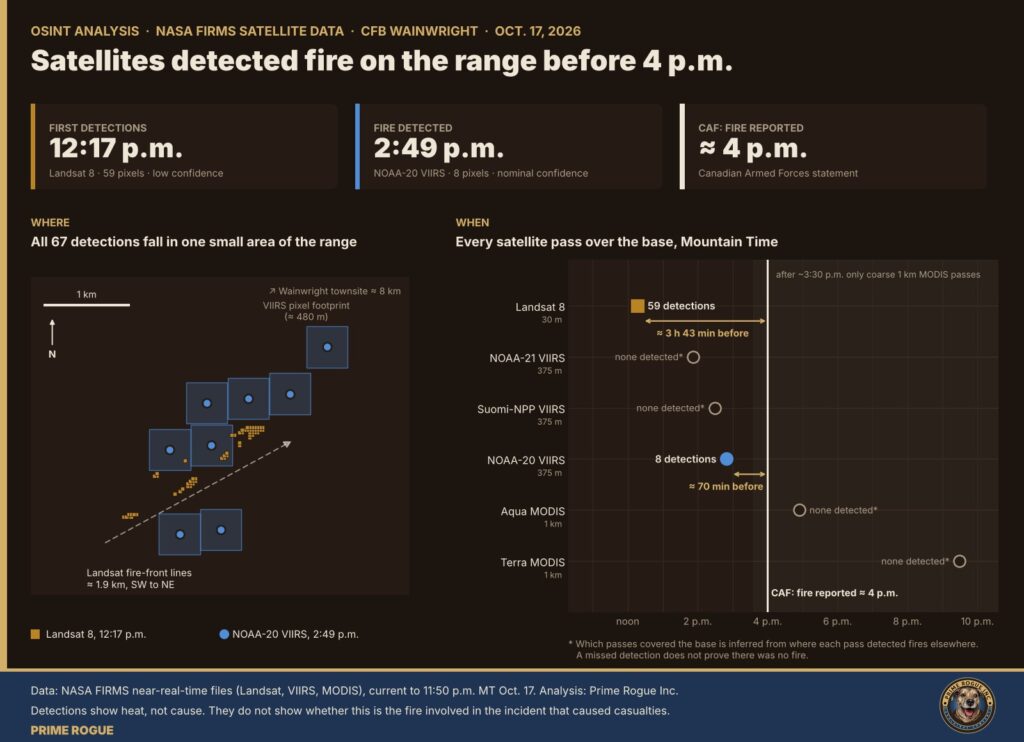
A Prime Rogue analysis of NASA satellite data shows fire on the base at 2:49 p.m. MDT, about 70 minutes before the approximately 4 p.m. ignition time in DND’s release. A Landsat satellite pass at 12:17 p.m., nearly four hours earlier, recorded lower-confidence detections at the same spot that appear to trace the narrow lines of an advancing grass fire.
The satellite record does not show what started the fire, and it cannot show whether this is the same fire involved in the incident that killed and injured military personnel. But it raises a question that investigators, and the families of those killed, are likely to ask: was a fire already burning on the range for hours, under a regional wind warning, before the deadly incident?
Defence Minister David McGuinty confirmed Saturday night that there had been “both fatalities and injuries” at the base. He gave no numbers. Global News, citing multiple military sources, reported seven dead and dozens injured. No official has confirmed a casualty figure.
Prime Rogue put questions about the satellite findings to the Department of National Defence and eight other agencies overnight. None had answered them by the time of publication.
NASA’s Fire Information for Resource Management System, known as FIRMS, publishes the location and time of heat signatures detected by several Earth-observing satellites, usually within minutes to a few hours of each pass. Prime Rogue reviewed every FIRMS file for Alberta and Canada covering the 24 hours that ended at 11:50 p.m. MT Saturday, across six instruments on six satellites.
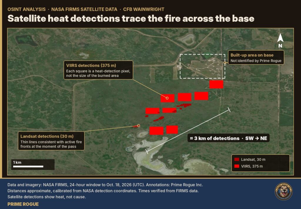
Within 40 kilometres of the base, there were 67 detections. All of them fall inside a single patch of the range roughly 2.4 km east to west and 2.2 km north to south, centred about eight kilometres south-southwest of the town of Wainwright. There were no other detections anywhere near the base.
| Time (MDT) | Satellite and sensor | Resolution | Result at CFB Wainwright |
|---|---|---|---|
| 12:17 p.m. | Landsat 8, Operational Land Imager | 30 m | 59 detections, all rated lower confidence, forming thin lines about 1.9 km long |
| ~1:52 p.m. | NOAA-21, VIIRS | 375 m | No detection* |
| ~2:29 p.m. | Suomi-NPP, VIIRS | 375 m | No detection* |
| 2:49 p.m. | NOAA-20, VIIRS | 375 m | 8 detections, all rated nominal confidence; 5.8 to 11.5 MW per pixel |
| ~4 p.m. | CAF: fire reported on the range. Global News, citing CAF sources: explosion at about 4 p.m. | ||
| ~4:55 p.m. | Aqua, MODIS | 1 km | No detection* |
| ~9:30 p.m. | Terra, MODIS (night) | 1 km | No detection* |
* Prime Rogue inferred that these passes covered the base from where each pass detected fires elsewhere. A missed detection does not prove there was no fire. See “How we did this” below.
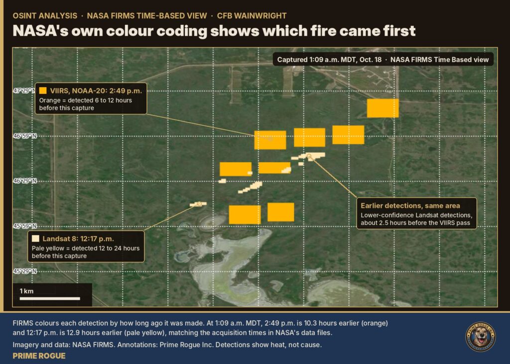
Landsat 8 carries the sharpest fire-detecting instrument in the FIRMS system. Its pixels are 30 metres across, fine enough to resolve the shape of a fire rather than just its presence. NASA says flaming fires as small as about four square metres have a better-than-even chance of being detected in daytime Landsat imagery.
At 12:17 p.m., Landsat 8 recorded 59 fire pixels on the range. They are not scattered. They line up in several narrow bands that run together for about 1.9 km on a southwest to northeast axis. That pattern is consistent with a moving grass fire: a thin front of flame, with burned ground behind it and unburned grass ahead.
FIRMS rates every one of these 59 pixels as lower confidence, the lowest of its three Landsat classes. On its own, a single low-confidence pixel should be treated with caution; NASA notes that Landsat detections can reflect thermal anomalies other than fire. But three things make a false reading unlikely here: the number of pixels, their arrangement into continuous fire-front lines, and the higher-quality VIIRS detections in the same place two and a half hours later, which show fire was present there that afternoon.
The VIIRS instrument on the NOAA-20 satellite recorded eight fire pixels on the range at 2:49 p.m. The satellite was fairly close to overhead, so its pixels were near their smallest and most accurate (about 480 metres across in this pass, against about 375 metres directly below the satellite).
All eight detections are rated nominal confidence. Under NASA’s definitions, nominal-confidence VIIRS pixels are free of potential sun-glint contamination and show a strong temperature anomaly, more than 15 kelvin above the background, in the instrument’s mid-infrared fire channel. Low-confidence daytime VIIRS pixels, by contrast, are typically associated with sun glint. None of the eight were low confidence.
The fire radiative power of each pixel, a measure of the heat the fire was giving off, ranged from 5.8 to 11.5 megawatts, about 75 megawatts in total. Values in that range are consistent with a relatively low-intensity vegetation fire such as a grass fire, though Prime Rogue has not compared them against published grassland studies. They do not, on their own, indicate anything unusual about the fire.
This is the strongest evidence in the record: by 2:49 p.m. MDT, a fire was burning on this part of the range.
Two other VIIRS passes, at about 1:52 p.m. (NOAA-21) and 2:29 p.m. (Suomi-NPP), and two MODIS passes, at about 4:55 p.m. (Aqua) and 9:30 p.m. (Terra), recorded no fire at the base.
Those results should not be over-read. Prime Rogue inferred that each pass covered the base from where it detected fires elsewhere in Western Canada; we have not confirmed each satellite’s exact footprint. A pass that views a location near the edge of its swath sees it at a steep angle, with larger pixels and less sensitivity, and a small or smouldering fire can fall below its detection threshold. Smoke and cloud can also hide a fire. MODIS pixels are 1 km across, too coarse to reliably catch a narrow, fast-moving grass fire.
The gap after 3:30 p.m. matters in a different way. After about 3:30 p.m. Saturday, no high-resolution satellite passed over the base until well after dark. Satellite data cannot show what happened on the range at or after 4 p.m., including the explosion.
Satellites detect heat. They do not detect causes, intentions or decisions. The data cannot tell us:
The Canadian Armed Forces said in a statement to media Saturday that at approximately 1600, a fire “was reported on the range” at the base, and that it had since spread beyond the boundary of the training area.
In a news release issued early Sunday from Ottawa, National Defence went further, saying a fire “ignited within the training area” at approximately 4 p.m. local time and “spread rapidly beyond the boundaries of the training area.” The release confirmed fatalities and injuries and said the CAF will not confirm casualty details until next-of-kin notification is complete. It does not mention an explosion, a cause, or any fire on the range before 4 p.m. It includes statements from McGuinty, Gen. Jennie Carignan and Lt.-Gen. Michael Wright, Commander of the Canadian Army.
The satellite record conflicts with DND’s stated ignition time. The only fire detected near the base was burning in the training area at 2:49 p.m., and likely by 12:17 p.m. Prime Rogue has asked DND to reconcile its timeline with the satellite data.
Wainwright RCMP said they were called to assist the base at around 4 p.m., and that early reports described a fire at a training area. Global News, citing multiple CAF sources, reported that “a live-fire training exercise hit a gas line or gas well on the base,” causing an explosion at around 4 p.m. MT. No official has confirmed that account. A 2014 Western Producer report described about 180 buried natural gas wells on the 148,000-acre base.
The Municipal District of Wainwright said the fire south of Wainwright “crossed the base fence earlier today and is being actively managed.” The MD did not say when. In an update at 10:47 p.m., the MD said the fire “is being held at this time.” Acute Care Alberta activated Code Orange, its mass-casualty protocol, at several facilities, and asked Edmonton-area residents to avoid the University of Alberta Hospital emergency department if possible.
Environment and Climate Change Canada had wind warnings in effect across central and east-central Alberta on Saturday, with gusts of up to 100 km/h expected in the Edmonton region. Edmonton International Airport recorded gusts of 98 km/h at about 2 p.m.
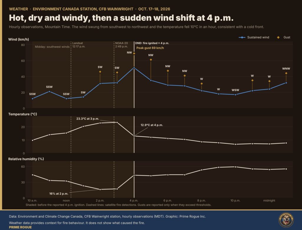
The base’s own Environment Canada weather station recorded a sharp change at the time of the reported explosion. At noon, around the Landsat pass, winds were light, from the south-southwest at about 12 km/h. By 2 p.m. and 3 p.m. they were blowing from the southwest at 31 to 32 km/h, gusting to 46 km/h, with a temperature of 23°C and humidity of 16 to 17 per cent. At 4 p.m. the wind had swung to the northwest at 51 km/h, gusting to 69 km/h, and the temperature had dropped 10 degrees, consistent with a cold front passing through. The southwest-to-northeast orientation of the Landsat fire lines matches the wind direction at midday. Prime Rogue draws no conclusion about cause from the weather record.
A single source with knowledge of the incident told Prime Rogue earlier Saturday night that a live-fire drill ignited the fire and caused a significant ammunition burn, and that soldiers prioritized treating casualties as the fire spread. Prime Rogue has not independently confirmed that account, and no official has said what training was under way. The satellite data neither confirms nor rules out that account or Global’s, though a fire burning on the range for hours before an explosion would be consistent with both.
If a fire was burning on a live-fire range from around midday, the decisions made between then and about 4 p.m. will be central to any investigation. They include whether training continued, whether ammunition or explosives were moved or left exposed, when outside fire services were called, and how wind conditions were assessed, including the forecast cold front that reached the base at about 4 p.m. Range Control logs, fire-danger readings and the exercise orders for Oct. 17 would show what was known, and when.
Prime Rogue intends to file access-to-information requests for those records.
Overnight, Prime Rogue asked each of the following when they were first notified of a fire on or near the base, or when they were first called to it. We asked DND and base public affairs directly about the satellite findings.
As of publication, none had responded to Prime Rogue’s questions. Earlier Saturday night, before Prime Rogue’s satellite analysis, DND said in an emailed statement that it was “aware of an incident in Wainwright, Alberta” and would provide more information “as it becomes available and can be confirmed.” DND has not addressed the satellite findings. Prime Rogue asked DND about them at [DND-QUESTION-TIME] MT.
Prime Rogue has given all agencies a second deadline of 7 a.m. MT Sunday for a follow-up report, and will publish their responses in full.
NASA FIRMS distributes near-real-time active-fire detections from three families of satellite instruments:
Each detection marks the centre of a pixel in which the satellite registered one or more fires or other heat sources. It is not an exact fire location, and it is not a measure of burned area. Fire radiative power, reported for VIIRS and MODIS, is the heat output of everything burning within the pixel, in megawatts. FIRMS reports acquisition times in UTC.
Prime Rogue downloaded ten FIRMS KML files shortly before midnight MT Saturday, each marked as current to 11:50 p.m. MT (05:50 UTC Oct. 18). They were the 24-hour Canada and Alberta files for Landsat, VIIRS on Suomi-NPP, NOAA-20 and NOAA-21, and MODIS. We downloaded a second, complete set at about 1:10 a.m. MT, current to 1:10 a.m. (07:10 UTC), and compared the two record by record. The detections near the base were identical: no detections were added, removed or revised. Both sets of original files are archived. FIRMS replaces these near-real-time files continually, so the archived versions are the contemporaneous record.
FIRMS data is public. Anyone can open the FIRMS map, navigate to approximately 52.78° N, 110.92° W, select the Landsat and VIIRS layers for Oct. 17, 2026, and click individual detections to see their acquisition times. NASA’s archive download service will also provide the standard (non-real-time) versions of this data in the coming days. Prime Rogue will share its extracted detection table with researchers and journalists on request.
No satellite has passed over CFB Wainwright since Saturday evening. As of the 1:10 a.m. MT data, the only new passes were nighttime VIIRS passes over Eastern Canada and Landsat and MODIS passes well south and west of Alberta.
The next VIIRS passes over Alberta are expected overnight, between roughly 2:30 and 5 a.m. MT, based on the timing of Friday night’s passes, from NOAA-21, Suomi-NPP and NOAA-20 in that order. VIIRS is sensitive to smouldering fire at night. Detections at the base would show the fire was still burning; no detections would be consistent with the MD of Wainwright’s statement that the fire is being held, though cloud and smoke can hide a fire. Daytime VIIRS passes follow between about 1:30 and 3:30 p.m. MT Sunday. Landsat is not expected to image the base again for several days.
Prime Rogue will publish a follow-up after the 7 a.m. MT deadline with any agency responses and the results of the overnight passes. We are also working to establish the times of the first emergency calls.
Prime Rogue’s live coverage of the CFB Wainwright fire continues here.
CAF families seeking information can call the CAF Family Information Line at 1-800-866-4546, 24 hours a day, or the Canadian Forces Member Assistance Program at 1-800-268-7708. The MD of Wainwright has directed people seeking information about loved ones to a public affairs line at 819-531-8618. Prime Rogue will not publish the names of anyone killed or injured until DND releases them.
Have information about the events at CFB Wainwright? Contact Kevin J.S. Duska Jr. through Prime Rogue’s secure channels
Signal: Rubicon49.50 Email: kevinjr.duska at proton . me
 Satellite record fits scenario that an exercise fire was burning before the CFB Wainwright incident
 LIVE: Deaths and injuries after fire at CFB Wainwright as wind-driven blaze crosses base fence
 Canada’s Military Playbook for the 2025 Kananaskis G7 Summit – 2025 G7 Security Series #2
 Canada’s 300,000-Person Reserve Plan: What’s Actually Happening | Prime Rogue



[…] NASA satellite data analyzed by Prime Rogue shows fire on the CFB Wainwright range at 2:49 p.m. MDT … Lower-confidence Landsat detections at the same spot at 12:17 p.m. appear to trace the lines of an advancing fire. The data does not show what caused the fire, or whether it is the same fire involved in the incident. Prime Rogue has asked DND to explain. Full details, graphic and method are below, and in our full analysis of the entire daily fire matrix at CFB Wainwright […]
[…] This follows Prime Rogue’s analysis published at 02:00 a.m. MT: Satellites saw fire on CFB Wainwright range hours before DND says it ignited. […]